
Search results
From International Robin Hood Bibliography
Page title matches
- • Map of English place-names – may take a while to open – open on new tab By Henrik Thiil Nielsen, 2013-06-08. Revised by … International place-names For international and British place-names see the following pages: Introduction This page lists Robin Hood-related place-names in England and summarizes the data through maps and charts. Under place-names are included localities certainly or possibly named after Robin Hood or subsidiary characters of the tradition, localities named after historical persons named Robin/Robert Hood or surnamed Littlejohn etc., localities with local traditions relating to Robin Hood or subsidiary characters, and localities that are mentioned or figure as locale in ballads, tales and dramas, mainly before c. 1600. Each locality has a page of its own, but the amount of detail provided varies considerably. For Robin Hood-related place-names in evidence in the Medieval or Early Modern period I generally provide more …3 KB (462 words) - 12:43, 17 June 2022
- 1,332 members (0 subcategories, 0 files) - 04:57, 27 May 2022
- #REDIRECT British place-names#scotland42 bytes (4 words) - 20:48, 24 November 2018
- When Robin Hood's Cave has been entered, I must note the odd coincidence that it is in Whitwell parish while Robin Hood's Cave in Rutland is located c. 1,2 km SW of another Whitwell. Robin Hood's Cave (Whitwell) in Derbyshire is included in PastScape.281 bytes (48 words) - 11:27, 9 November 2018
- 1 member (0 subcategories, 0 files) - 12:45, 10 May 2018
- 4 members (0 subcategories, 0 files) - 12:45, 10 May 2018
- 3 members (0 subcategories, 0 files) - 12:45, 10 May 2018
- 11 members (0 subcategories, 0 files) - 04:04, 27 May 2022
- 19 members (0 subcategories, 0 files) - 04:06, 27 May 2022
- 15 members (15 subcategories, 0 files) - 12:40, 10 May 2018
- 0 members (0 subcategories, 0 files) - 12:46, 10 May 2018
- 0 members (0 subcategories, 0 files) - 12:47, 10 May 2018
- 6 members (0 subcategories, 0 files) - 12:47, 10 May 2018
- 0 members (0 subcategories, 0 files) - 12:47, 10 May 2018
- 1 member (0 subcategories, 0 files) - 12:48, 10 May 2018
- 8 members (0 subcategories, 0 files) - 12:48, 10 May 2018
- 3 members (0 subcategories, 0 files) - 12:49, 10 May 2018
- 5 members (0 subcategories, 0 files) - 12:49, 10 May 2018
- 1 member (0 subcategories, 0 files) - 12:49, 10 May 2018
- By Henrik Thiil Nielsen, 2018-02-12. Revised by … County description The Historic Counties Trust describes Herefordshire as follows: Herfordshire is only English county wholly west of the Severn. It is also possibly England's most rural county. Indeed it is said that outside Hereford and Leominster the population has not increased since the Middle Ages. The hills are rugged green pasture, with deep river valleys along which the shire's villages are found. The foothills of Brecknockshire's Black Mountains begin in western Herefordshire, some standing at 2,000 feet. East of them the land comes in a number of great northwest-southeast folds, including the famous Golden Valley. The very east of the county rises into the whaleback of the Malvem Hills, forming the border with Worcestershire. The major river of Herefordshire is the Wye, which runs from Clifford next to the bounds of Radnorshire down to Hereford then writhes toward Ross-on-Wye before running out of the county. The …4 KB (519 words) - 05:06, 27 May 2022
Page text matches
File:Postcard Anonymous 19xxb.jpg category:Place-names-images category:Postcards-images(1,635 × 1,025 (155 KB)) - 03:59, 2 July 2014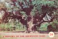
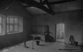
File:Anonymous 1966a.jpg category:Place-names-images category:Sources-images(2,128 × 1,436 (1.47 MB)) - 03:33, 2 July 2014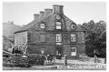
File:Robin Hood and Little John Little Matlock Postcard.jpg From: http://www.sheffieldhistory.co.uk/forums/index.php/topic/3531-pubs-n-to-s-keepers-picture-links/page-12 category:Place-names-images category:Postcards-images(715 × 472 (107 KB)) - 03:58, 2 July 2014
File:Flag-yorkshire.png category:Place-names-images category:Postcards-images(100 × 60 (5 KB)) - 04:00, 2 July 2014
File:Flag-yorkshire-west-riding.png category:Place-names-images category:Postcards-images(100 × 60 (4 KB)) - 04:01, 2 July 2014
File:Flag of Jersey.png category:Place-names-images category:Postcards-images(100 × 60 (4 KB)) - 04:00, 2 July 2014
File:Hughes peter robin hood wood silsden.jpg From http://www.flickr.com/photos/47523307@N08/6276110561/in/photolist-ayAH1M category:Place-names-images(1,024 × 732 (258 KB)) - 04:18, 2 July 2014
File:Robin hood cyprus.jpg category:Place-names-images(2,048 × 1,365 (510 KB)) - 04:10, 2 July 2014
File:Flag-thailand.png category:Place-names-images(100 × 67 (344 bytes)) - 04:15, 2 July 2014
File:Flag-bangkok.png category:Place-names-images(100 × 67 (3 KB)) - 03:37, 2 July 2014
File:Robin hood sukhumvit bangkok google earth.jpg category:Place-names-images(1,267 × 900 (314 KB)) - 04:09, 2 July 2014
File:Flag-cyprus.png category:Place-names-images(100 × 67 (2 KB)) - 03:41, 2 July 2014
File:Sutcliffe halliwell 1899a robin hood's well.jpg category:Place-names-images(687 × 478 (55 KB)) - 03:27, 2 July 2014
File:Sutcliffe halliwell 1899a little john's well.jpg category:Place-names-images(691 × 359 (71 KB)) - 03:27, 2 July 2014
File:Sutcliffe halliwell 1899a will scarlet's well.jpg category:Place-names-images(680 × 400 (64 KB)) - 03:27, 2 July 2014
File:Robin hood road ravenscar google earth.jpg category:Place-names-images(1,372 × 901 (169 KB)) - 10:03, 12 August 2015
File:Robin hood's butts stoup brow moor andrew curtis.jpg category:Place-names-images(640 × 480 (87 KB)) - 03:58, 2 July 2014
File:Robin hood tunnel berry brow huddersfield.jpg category:Place-names-images(971 × 735 (89 KB)) - 04:09, 2 July 2014
File:Hood street berry brow huddersfield google earth.jpg category:Place-names-images(900 × 716 (96 KB)) - 04:18, 2 July 2014
File:Robin hood's penny stone midgley moor richard carter.jpg category:Place-names-images(1,024 × 682 (633 KB)) - 04:10, 2 July 2014


