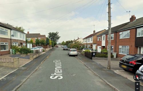
Sherwood Road (Sutton)
By Henrik Thiil Nielsen, 2017-01-18. Revised by Henrik Thiil Nielsen, 2019-04-05.
Very likely the name of this street and that of Robin Hood Avenue in the south of Macclesfield, a little west of Sutton, were inspired by the presence, at least as late as 1938, of (what was probably) a farmstead named 'Robinhood' in the immediate vicinity. I do not know when Sherwood Road was established, but it is not included on any of the O.S. maps listed below, the latest of which was based on surveying done in 1938 (see Maps section). Some of the houses, especially on the east side of the street, do not look recent but were probably built sometime during the second half of the 20th century. My guess is that the road (and its name) date from not long after the end of World War II.
Gazetteers
- Not included in Dobson, R. B., ed.; Taylor, J., ed. Rymes of Robyn Hood: an Introduction to the English Outlaw (London, 1976), pp. 293-311.
- Not included in Dodgson, John McN.; Rumble, Alexander R. The Place-Names of Cheshire, pts. I-V (English Place-Name Society, vols. XLIV-XLVIII, LIV, LXXIV) (Cambridge, 1970-72; [s.l.], 1981; Nottingham, 1997).
Maps
Maps of the area; Robin Hood Avenue not indicated as it did not yet exist.
- 6" O.S. map Cheshire XXXVI (1882; surveyed 1871-72)
- 6" O.S. map Cheshire XXXVI.SE (1898; rev. 1896-97)
- 6" O.S. map Cheshire XXXVI.SE (1898; rev. 1896-97) (georeferenced)
- 6" O.S. map Cheshire XXXVI.SE (1910; rev. 1907)
- 6" O.S. map Cheshire XXXVI.SE (c. 1933; rev. 1907)
- 6" O.S. map Cheshire XXXVI.SE (c. 1937; rev. 1907)
- 6" O.S. map Cheshire XXXVI.SE (c. 1944; rev. c. 1938).

