
Sherwood Place (Wolston Close, Solihull): Difference between revisions
From International Robin Hood Bibliography
m (Text replacement - "=== Sources ===" to "== Sources ==") |
m (Text replacement - "=== Maps ===" to "== Maps ==") |
||
| Line 6: | Line 6: | ||
<!--== Gazetteers == | <!--== Gazetteers == | ||
== Sources ==--> | == Sources ==--> | ||
== Maps == | |||
* [https://maps.nls.uk/view/115633969#zoom=3&lat=3463&lon=6333&layers=BT 25" O.S. map ''Warwickshire'' XIX.7 (1888; surveyed 1886)] | * [https://maps.nls.uk/view/115633969#zoom=3&lat=3463&lon=6333&layers=BT 25" O.S. map ''Warwickshire'' XIX.7 (1888; surveyed 1886)] | ||
* [https://maps.nls.uk/view/115633972#zoom=3&lat=3838&lon=6915&layers=BT 25" O.S. map ''Warwickshire'' XIX.7 (1904; rev. 1903)] | * [https://maps.nls.uk/view/115633972#zoom=3&lat=3838&lon=6915&layers=BT 25" O.S. map ''Warwickshire'' XIX.7 (1904; rev. 1903)] | ||
Revision as of 14:40, 12 July 2018
Sherwood Place
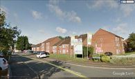
[[File:|thumb|right|500px|Sherwood Place / Google Earth Street View.]]
By Henrik Thiil Nielsen, 2018-05-25. Revised by Henrik Thiil Nielsen, 2018-07-12.
A housing complex on Pailton Road/Wolston Close, Solihull, built c. 2013, is named Sherwood Place, a name perhaps inspired by the presence of several localities with Robin Hood-related names in the area. It seems to have been built c. 2013.[1]
Maps
- 25" O.S. map Warwickshire XIX.7 (1888; surveyed 1886)
- 25" O.S. map Warwickshire XIX.7 (1904; rev. 1903)
- 25" O.S. map Warwickshire XIX.7 (1904; rev. 1903) (georeferenced)
- 25" O.S. map Warwickshire XIX.7 (1917; rev. 1913-14)
- 25" O.S. map Warwickshire XIX.7 (1939; rev. 1937)
- 6" O.S. map Warwickshire XIX.NE (1886; surveyed 1886)
- 6" O.S. map Warwickshire XIX.NE (1905; rev. 1902-1903)
- 6" O.S. map Warwickshire XIX.NE (1905; rev. 1902-1903) (georeferenced)
- 6" O.S. map Warwickshire XIX.NE (1920; rev. 1913-14)
- 6" O.S. map Warwickshire XIX.NE (c. 1946; rev. 1938).
Background
Notes
- ↑ The flats had sold out by 16 Jul. 2014, see Geograph: SP1180 : Sherwood Place, development.
Sherwood Place / Google Earth Street View.

Sherwood Place / [geograph-4075159-by-Alex-McGregor Alex McGregor, 16 Jul. 2014, Creative Commons, via Geograph.]

