
Rough Low Tor (Buxton): Difference between revisions
m (Text replacement - "|service=leaflet}}" to "|service=leaflet|enablefullscreen=yes}}") |
m (→Maps) |
||
| Line 18: | Line 18: | ||
== Maps == | == Maps == | ||
* 25" O.S. map ''Derbyshire'' XIV.12 (''c.'' 1879; surveyed ''c.'' 1878). No Copy in NLS | |||
* [https://maps.nls.uk/geo/explore/#zoom=16&lat=53.2705&lon=-1.9395&layers=168&b=5 25" O.S. map ''Derbyshire'' XIV.12 (1898; rev. 1897)] (georeferenced) | |||
* [https://maps.nls.uk/view/114586931#zoom=3&lat=3226&lon=9565&layers=BT 25" O.S. map ''Derbyshire'' XIV.12 (1898; rev. 1897)] | |||
* [https://maps.nls.uk/view/114586934#zoom=4&lat=3254&lon=10013&layers=BT 25" O.S. map ''Derbyshire'' XIV.12 (1922; rev. 1919)] | |||
* [https://maps.nls.uk/view/101600298#zoom=4&lat=4551&lon=6366&layers=BT 6" O.S. map ''Derbyshire'' XIV.SE (1882; surveyed 1878-79)] | * [https://maps.nls.uk/view/101600298#zoom=4&lat=4551&lon=6366&layers=BT 6" O.S. map ''Derbyshire'' XIV.SE (1882; surveyed 1878-79)] | ||
* [https://maps.nls.uk/geo/explore/#zoom=15&lat=53.2714&lon=-1.9395&layers=6&b=5 6" O.S. map ''Derbyshire'' XIV.SE (1899; rev. 1897)] (georeferenced) | * [https://maps.nls.uk/geo/explore/#zoom=15&lat=53.2714&lon=-1.9395&layers=6&b=5 6" O.S. map ''Derbyshire'' XIV.SE (1899; rev. 1897)] (georeferenced) | ||
* [https://maps.nls.uk/view/101600295#zoom=4&lat=4082&lon=6623&layers=BT 6" O.S. map ''Derbyshire'' XIV.SE (1899; rev. 1897)] | * [https://maps.nls.uk/view/101600295#zoom=4&lat=4082&lon=6623&layers=BT 6" O.S. map ''Derbyshire'' XIV.SE (1899; rev. 1897)] | ||
* [https://maps.nls.uk/view/102341301#zoom=4&lat=4484&lon=13908&layers=BT 6" O.S. map ''Derbyshire'' XIV (1923; rev. 1897-1919)] | * [https://maps.nls.uk/view/102341301#zoom=4&lat=4484&lon=13908&layers=BT 6" O.S. map ''Derbyshire'' XIV (1923; rev. 1897-1919)] | ||
* [https://maps.nls.uk/view/101600292#zoom=4&lat=4412&lon=6804&layers=BT 6" O.S. map ''Derbyshire'' XIV.SE (1923; rev. 1919)] | * [https://maps.nls.uk/view/101600292#zoom=4&lat=4412&lon=6804&layers=BT 6" O.S. map ''Derbyshire'' XIV.SE (1923; rev. 1919)] | ||
* [https://maps.nls.uk/view/102193473#zoom=4&lat=4298&lon=6751&layers=BT 6" O.S. map ''Derbyshire'' XIV.SE (''c.'' 1946; rev. 1938 | * [https://maps.nls.uk/view/102193473#zoom=4&lat=4298&lon=6751&layers=BT 6" O.S. map ''Derbyshire'' XIV.SE (''c.'' 1946; rev. 1938).] | ||
<!--== Discussion == | <!--== Discussion == | ||
== Background == | == Background == | ||
| Line 33: | Line 33: | ||
== Brief mention ==--> | == Brief mention ==--> | ||
{{PnItemAlsoSee}} | {{PnItemAlsoSee}} | ||
== Notes == | == Notes == | ||
<references/> | <references/> | ||
Revision as of 16:10, 30 May 2019
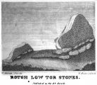
[[File:|thumb|right|500px|The Rough Low Tor Stones / Marriott, William. Antiquities of Lyme and its Vicinity (1810), plate facing p. 8.]]
By Henrik Thiil Nielsen, 2019-02-21. Revised by Henrik Thiil Nielsen, 2019-05-30.
According to William Marriott's Antiquities of Lyme and its Vicinity, published 1810 (see Allusions below), there was a local tradition that Robin Hood had shot an arrow from Chinley Churn to a locality named 'Rough Low Tor'. The latter place-name is no longer current, but it would have referred to a hill somewhere north of Buxton and south of Combs in the High Peak.
The spot where the arrow landed was marked by a monument consisting of two large stones (see illustration in image gallery below). The latter sat in a field which in 1810 was known as 'Hurst Piece'. Here is Marriott's description of the locality and the stones:
These are of a very singular and ancient fashion. They consist of two short flat stones, placed with their flat sides towards the north. The most northerly one is broken down almost to nothing. The southerly is perfect, and something in the form of a half S reversed. Its narrow front to the west is distinctly marked with two indentures from one extremity to the other; one of which is particularly visible. They have no base, but stick like wedges in the ground. The larger one is [p. 10:] to all appearances perfect, and on one side has a triangular projection.[1]
He later describes the hills and rocks near this place in so much detail that a reader with first-hand knowledge of the area could probably identify the spot.[2]
For the alleged connection between this monument and others in the High Peak, see High Peak place-name cluster. Template:PnItemQry
Gazetteers
- Not included in Dobson, R. B., ed.; Taylor, J., ed. Rymes of Robyn Hood: an Introduction to the English Outlaw (London, 1976), pp. 293-311.
Sources
- Marriott, William. The Antiquities of Lyme and its Vicinity (Stockport, 1810), pp. 9-10, 18-27, 46-47, 288.
Maps
- 25" O.S. map Derbyshire XIV.12 (c. 1879; surveyed c. 1878). No Copy in NLS
- 25" O.S. map Derbyshire XIV.12 (1898; rev. 1897) (georeferenced)
- 25" O.S. map Derbyshire XIV.12 (1898; rev. 1897)
- 25" O.S. map Derbyshire XIV.12 (1922; rev. 1919)
- 6" O.S. map Derbyshire XIV.SE (1882; surveyed 1878-79)
- 6" O.S. map Derbyshire XIV.SE (1899; rev. 1897) (georeferenced)
- 6" O.S. map Derbyshire XIV.SE (1899; rev. 1897)
- 6" O.S. map Derbyshire XIV (1923; rev. 1897-1919)
- 6" O.S. map Derbyshire XIV.SE (1923; rev. 1919)
- 6" O.S. map Derbyshire XIV.SE (c. 1946; rev. 1938).
Notes
Marriott, William. Antiquities of Lyme and its Vicinity (1810), plate facing p. 8.
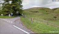
The Old Road from Butxon to Whaley Bridge. Rough Low Tor seems to have been somwehere to the east of it / Google Earth Street View.

