
Robinhood Pool (Hazel Grove): Difference between revisions
mNo edit summary |
m (Text replacement - "* 25" map" to "* 25" O.S. map") |
||
| (3 intermediate revisions by the same user not shown) | |||
| Line 5: | Line 5: | ||
The Robinhood Pool was located immediately east of the [[Robin Hood Inn (Hazel Grove)|Robin Hood Inn]] in Hazel Grove, south of Stockport. The earliest known reference to the name 'Robinhood Pool' is an O.S. map from 1881. | The Robinhood Pool was located immediately east of the [[Robin Hood Inn (Hazel Grove)|Robin Hood Inn]] in Hazel Grove, south of Stockport. The earliest known reference to the name 'Robinhood Pool' is an O.S. map from 1881. | ||
The pool figures as 'Pond' ''tout court'' in the 1849 tithe award for Norbury Moor. The then township of Norbury, with Norbury Moor, is now part of Hazel Grove. The landowner was Thomas Legh, Esq., the occupiers Clayton & Brooke. The property covered an area of 2 roods and 25 perches ({{AcresRoodsPerchesToM2|0|2|25}} m<sup>2</sup>).<ref>1849 tithe award for the 'Township of Norbury in the Parish of Stockport' [actually Norbury Moor], online at the [https://www.thegenealogist.com Genealogist], | The pool figures as 'Pond' ''tout court'' in the 1849 tithe award for Norbury Moor. The then township of Norbury, with Norbury Moor, is now part of Hazel Grove. The landowner was Thomas Legh, Esq., the occupiers Clayton & Brooke. The property covered an area of 2 roods and 25 perches ({{AcresRoodsPerchesToM2|0|2|25}} m<sup>2</sup>).<ref>1849 tithe award for the 'Township of Norbury in the Parish of Stockport' [actually Norbury Moor], online at the [https://www.thegenealogist.com Genealogist], Piece 05, sub-piece 297, Image 008, #269 (£); accompanying map, online at the [https://www.thegenealogist.com Genealogist], Piece 05, sub-piece 297, Sub-Image 001, #269 (£). Also see {{:Dodgson, John McNeal 1970a}}, vol. I, p. 288.</ref> There cannot be much doubt that the pool was named after the pub. | ||
This is not the only pool located close to a Robin Hood pub. In Cherry Hinton, Cambridgeshire, across the street from a public house named the [[Robin Hood (Cherry Hinton)|Robin Hood]] we find [[Robin Hood Dip (Cherry Hinton)|Robin Hood Dip]], which contains a small island, the Giant's Grave. | This is not the only pool located close to a Robin Hood pub. In Cherry Hinton, Cambridgeshire, across the street from a public house named the [[Robin Hood (Cherry Hinton)|Robin Hood]] we find [[Robin Hood Dip (Cherry Hinton)|Robin Hood Dip]], which contains a small island, the Giant's Grave. | ||
| Line 13: | Line 13: | ||
== MS sources == | == MS sources == | ||
* 1849 tithe award for the 'Township of Norbury in the Parish of Stockport' [actually Norbury Moor], online at the [https://www.thegenealogist.com Genealogist], | * 1849 tithe award for the 'Township of Norbury in the Parish of Stockport' [actually Norbury Moor], online at the [https://www.thegenealogist.com Genealogist], Piece 05, sub-piece 297, Image 008, #269 (£) | ||
* accompanying map, online at the [https://www.thegenealogist.com Genealogist], | * accompanying map, online at the [https://www.thegenealogist.com Genealogist], Piece 05, sub-piece 297, Sub-Image 001, #269 (£). | ||
== Printed sources == | == Printed sources == | ||
| Line 20: | Line 20: | ||
== Maps == | == Maps == | ||
* 25" map ''Cheshire'' XX.9 (''c.'' 1877; surveyed ''c.'' 1876). No copy in NLS. | * 25" O.S. map ''Cheshire'' XX.9 (''c.'' 1877; surveyed ''c.'' 1876). No copy in NLS. | ||
* [https://maps.nls.uk/geo/explore/#zoom=17&lat=53.36754&lon=-2.09432&layers=168&b=5 25" O.S. map ''Cheshire'' XX.9 (1898; rev. 1896)] (georeferenced) | * [https://maps.nls.uk/geo/explore/#zoom=17&lat=53.36754&lon=-2.09432&layers=168&b=5 25" O.S. map ''Cheshire'' XX.9 (1898; rev. 1896)] (georeferenced) | ||
* [https://maps.nls.uk/view/114582031#zoom=5&lat=5963&lon=7598&layers=BT 25" O.S. map ''Cheshire'' XX.9 (1898; rev. 1896–97)] | * [https://maps.nls.uk/view/114582031#zoom=5&lat=5963&lon=7598&layers=BT 25" O.S. map ''Cheshire'' XX.9 (1898; rev. 1896–97)] | ||
Latest revision as of 16:44, 8 May 2022
| Locality | |
|---|---|
| Coordinate | 53.368, -2.0942 |
| Adm. div. | Cheshire |
| Vicinity | On the north side of Buxton Road, immediately west of Norbury Hollow Road |
| Type | Natural feature |
| Interest | Robin Hood name |
| Status | Defunct |
| First Record | 1881 |
| A.k.a. | Robin Hood Pool; Pond |

By Henrik Thiil Nielsen, 2017-01-19. Revised by Henrik Thiil Nielsen, 2022-05-08.
The Robinhood Pool was located immediately east of the Robin Hood Inn in Hazel Grove, south of Stockport. The earliest known reference to the name 'Robinhood Pool' is an O.S. map from 1881.
The pool figures as 'Pond' tout court in the 1849 tithe award for Norbury Moor. The then township of Norbury, with Norbury Moor, is now part of Hazel Grove. The landowner was Thomas Legh, Esq., the occupiers Clayton & Brooke. The property covered an area of 2 roods and 25 perches (2655.75 m2).[1] There cannot be much doubt that the pool was named after the pub.
This is not the only pool located close to a Robin Hood pub. In Cherry Hinton, Cambridgeshire, across the street from a public house named the Robin Hood we find Robin Hood Dip, which contains a small island, the Giant's Grave.
Gazetteers
- Not included in Dobson, R. B., ed.; Taylor, J., ed. Rymes of Robyn Hood: an Introduction to the English Outlaw (London, 1976), pp. 293-311.
MS sources
- 1849 tithe award for the 'Township of Norbury in the Parish of Stockport' [actually Norbury Moor], online at the Genealogist, Piece 05, sub-piece 297, Image 008, #269 (£)
- accompanying map, online at the Genealogist, Piece 05, sub-piece 297, Sub-Image 001, #269 (£).
Printed sources
Maps
- 25" O.S. map Cheshire XX.9 (c. 1877; surveyed c. 1876). No copy in NLS.
- 25" O.S. map Cheshire XX.9 (1898; rev. 1896) (georeferenced)
- 25" O.S. map Cheshire XX.9 (1898; rev. 1896–97)
- 25" O.S. map Cheshire XX.9 (1938; rev. 1936)
- 25" O.S. map Cheshire XX.9 (1934; rev. 1907)
- 6" O.S. map Cheshire XX (1881; surveyed 1871–72)
- 6" O.S. map Cheshire XX.SW (1899; rev. 1896-97) (georeferenced)
- 6" O.S. map Cheshire XX.SW (1899; rev. 1896-97)
- 6" O.S. map Cheshire XX.SW (1912; rev. 1907)
- 6" O.S. map Cheshire XX.SW (c. 1946; rev. 1938).
Also see
Notes
- ↑ 1849 tithe award for the 'Township of Norbury in the Parish of Stockport' [actually Norbury Moor], online at the Genealogist, Piece 05, sub-piece 297, Image 008, #269 (£); accompanying map, online at the Genealogist, Piece 05, sub-piece 297, Sub-Image 001, #269 (£). Also see Dodgson, John McN.; Rumble, Alexander R. The Place-Names of Cheshire, pts. I-V (English Place-Name Society, vols. XLIV-XLVIII, LIV, LXXIV) (Cambridge, 1970-72; [s.l.], 1981; Nottingham, 1997), vol. I, p. 288.
Image gallery
Click any image to display it in the lightbox, where you can navigate between images by clicking in the right or left side of the current image.
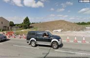
The site of Robinhood Pool / Google Earth Street View.

Yellow marker bottom centre indicates site of Robinhood Pool; seen from the air before construction work seen in preceding photo began / Google Earth Street View.
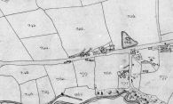
Detail of 1849 tithe map. Robin Hood Inn (#321); proprietor's garden (#318); Robinhood Pool (#269) (click or tap to enlarge) / © Crown Copyright Images reproduced by courtesy of The National Archives, London, England. www.NationalArchives.gov.uk and www.TheGenealogist.co.uk.

