
Robinhood Lane (Mitcham): Difference between revisions
mNo edit summary |
m (Text replacement - "data3=[[pnadmdiv::{{#var:County}}]]" to "data3=[[pnadmdiv::{{#var:AdmDiv}}]]") |
||
| Line 5: | Line 5: | ||
|data2=[[Geopoint::{{#var:Lat}},{{#var:Lon}}]] | |data2=[[Geopoint::{{#var:Lat}},{{#var:Lon}}]] | ||
|label3=Adm. div. | |label3=Adm. div. | ||
|data3=[[pnadmdiv::{{#var: | |data3=[[pnadmdiv::{{#var:AdmDiv}}]] | ||
|label4=Vicinity | |label4=Vicinity | ||
|data4=[[pnvicinity::]] | |data4=[[pnvicinity::]] | ||
Revision as of 01:36, 1 December 2017
| Locality | |
|---|---|
| Coordinates | The following coordinate was not recognized: ,.The following coordinate was not recognized: ,. |
| Adm. div. | |
| Vicinity | |
| Type | Thoroughfare |
| Interest | Robin Hood name |
| Status | Extant |
| First Record | 1936 |

By Henrik Thiil Nielsen, 2017-11-29. Revised by Henrik Thiil Nielsen, 2017-12-01.
Robinhood Lane in Mitcham leads southwest from Manor Road in an area bounded by the latter, Sherwood Park Road and Wide Way. Northwest of Abbotts Road it is a proper street, but southwest of it passage is blocked by a green iron gate, and beyond the gate the lane is little more than a rut or footpath between gardens and garages, The earliest reference I have found is a 6" O.S. map published 1936, based on surveying done in 1932 (see Maps section below). Several streets in the vicinity have Robin Hood-related names.
Gazetteers
- Not included in Dobson, R. B., ed.; Taylor, J., ed. Rymes of Robyn Hood: an Introduction to the English Outlaw (London, 1976), pp. 293-311.
Maps
- 6" O.S. map Surrey XIV (1872; surveyed 1867-68) (R. Lane not shown or labelled)
- 6" O.S. map Surrey XIV.NW (1898; rev. 1894-95) (R. Lane not shown or labelled)
- 6" O.S. map Surrey XIV.NW (1898; rev. 1894-95) (R. Lane not shown or labelled) (georeferenced)
- 6" O.S. map Surrey XIV.NW (1914; rev. 1910-11) (R. Lane not shown or labelled)
- 6" O.S. map Surrey XIV.NW (1936; rev. 1932) (R. Lane shown and labelled)
- 6" O.S. map Surrey XIV.NW (c. 1944; rev. 1938) (R. Lane shown and labelled)
- 6" O.S. map Surrey XIV.NW (1946; rev. 1938) (R. Lane shown and labelled)
Also see
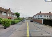
On Robinhood Lane northwest of Abbotts Road, looking southeast / Google Earth Street View.
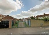
On Abbotts Road, looking southeast down Robinhood Lane / Google Earth Street View.
