
Robinhood End Farm (Finchingfield): Difference between revisions
From International Robin Hood Bibliography
m (Text replacement - "{{#display_map:{{#var:Coords}}|" to "{{#display_map:{{#var:Coords}}~{{PAGENAME}}|") |
m (Text replacement - "{{#var:Coords}}~{{PAGENAME}}" to "{{#var:Coords}}~{{#replace:{{PAGENAME}}|'|'}}") |
||
| Line 1: | Line 1: | ||
__NOTOC__{{PnItemTop|Lat=52.0047|Lon=0.4903|AdmDiv=Essex|Vicinity=4.82 km NE of Finchingfield|Type=Building|Interest=Robin Hood name|Status=Extant|Demonym=|Riding=|GreaterLondon=|Year=1777|Aka=Robinhoodend Farm|Century=|Cluster1=Robinhood End|Cluster2=|Cluster3=|Image=Robinhood end farm finchampstead.jpg|Postcards=|ExtraCat1=|ExtraCat2=|ExtraCat3=|ExtraCat4=|ExtraCat5=|ExtraLink1=|ExtraLink2=|ExtraLink3=|ExtraLink4=|ExtraLink5=|ExtraLinkName1=|ExtraLinkName2=|ExtraLinkName3=|ExtraLinkName4=|ExtraLinkName5=|GeopointPrefix=|GeopointSuffix=|StatusSuffix=|DatePrefix=|DateSuffix=}} | __NOTOC__{{PnItemTop|Lat=52.0047|Lon=0.4903|AdmDiv=Essex|Vicinity=4.82 km NE of Finchingfield|Type=Building|Interest=Robin Hood name|Status=Extant|Demonym=|Riding=|GreaterLondon=|Year=1777|Aka=Robinhoodend Farm|Century=|Cluster1=Robinhood End|Cluster2=|Cluster3=|Image=Robinhood end farm finchampstead.jpg|Postcards=|ExtraCat1=|ExtraCat2=|ExtraCat3=|ExtraCat4=|ExtraCat5=|ExtraLink1=|ExtraLink2=|ExtraLink3=|ExtraLink4=|ExtraLink5=|ExtraLinkName1=|ExtraLinkName2=|ExtraLinkName3=|ExtraLinkName4=|ExtraLinkName5=|GeopointPrefix=|GeopointSuffix=|StatusSuffix=|DatePrefix=|DateSuffix=}} | ||
{{#display_map:{{#var:Coords}}~{{PAGENAME}}|controls=type,streetview|typestyle=dropdown|width=34%}}<div class="pnMapLegend">Robin Hood End Farm.</div> | {{#display_map:{{#var:Coords}}~{{#replace:{{PAGENAME}}|'|'}}|controls=type,streetview|typestyle=dropdown|width=34%}}<div class="pnMapLegend">Robin Hood End Farm.</div> | ||
[[File:Robinhood end farm finchampstead.jpg|thumb|right|500px|Robinhood End Farm / Google Earth Street View.]] | [[File:Robinhood end farm finchampstead.jpg|thumb|right|500px|Robinhood End Farm / Google Earth Street View.]] | ||
[[File:Chapman and andre 1777a rh farm and rhs end.jpg|thumb|right|500px|To the left, Robinhood End Farm ('Robin Hoods Farm') and Robin Hood End / From superb scan of entire map at [http://bvpb.mcu.es/ca/consulta/resultados_navegacion.cmd?posicion=1&forma=ficha&id=258 Biblioteca Virtual del Patrimoni Bibliogràfico] (click image to enlarge).]] | [[File:Chapman and andre 1777a rh farm and rhs end.jpg|thumb|right|500px|To the left, Robinhood End Farm ('Robin Hoods Farm') and Robin Hood End / From superb scan of entire map at [http://bvpb.mcu.es/ca/consulta/resultados_navegacion.cmd?posicion=1&forma=ficha&id=258 Biblioteca Virtual del Patrimoni Bibliogràfico] (click image to enlarge).]] | ||
Revision as of 04:28, 21 June 2018
Robin Hood End Farm.


To the left, Robinhood End Farm ('Robin Hoods Farm') and Robin Hood End / From superb scan of entire map at Biblioteca Virtual del Patrimoni Bibliogràfico (click image to enlarge).
By Henrik Thiil Nielsen, 2016-06-25. Revised by Henrik Thiil Nielsen, 2018-06-21.
Robinhood End Farm in Stambourne parish[1] is located 4.82 km NE of Finchingfield and c. 600 m NNE of the hamlet of Robinhood End. This place-name is first known from Chapman and André's 1777 map of Essex (see Maps section below),[2] where it appears as "Robin Hood Farm".[3] On the 6" O.S. map of the area published in 1880 the locality is labelled "Robinhoodend Farm" [sic].[4]
Gazetteers
- Dobson, R. B., ed.; Taylor, J., ed. Rymes of Robyn Hood: an Introduction to the English Outlaw (London, 1976), p. 297, s.n. Robinhood End Farm.
Sources
- Reaney, P.H. The Place-Names of Essex (English Place-Name Society, vol. XII) (Cambridge, 1969), p. 457; and see p. xl for Reaney's source;; p. 456 for the parish.
Maps
- Chapman, John, cartog.; André, Peter, cartog. A Map of the County of Essex: from an Actual Survey Taken in MDCCLXXII, LXXIII & MDCCLXXIV (London, 1777), plate III.
- 6" O.S. map Essex X (1880, surveyed 1876-77)
- 6" O.S. map Essex X.SE (1898, rev. 1896.)
Notes
- ↑ Reaney, P.H. The Place-Names of Essex (English Place-Name Society, vol. XII) (Cambridge, 1969), p. 456.
- ↑ Reaney, P.H. The Place-Names of Essex (English Place-Name Society, vol. XII) (Cambridge, 1969), p. 457.
- ↑ 'Robinhood Farm' in Dobson, R. B., ed.; Taylor, J., ed. Rymes of Robyn Hood: an Introduction to the English Outlaw (London, 1976), p. 297, s.n. Robinhood End Farm, is a mistake.
- ↑ 6" O.S. map Essex X (1880, surveyed 1876-77).
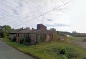
Robinhood End Farm / Google Earth Street View.
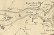
To the left, Robinhood End Farm ('Robin Hoods Farm') and Robin Hood End / From superb scan of entire map at Biblioteca Virtual del Patrimoni Bibliogràfico (click image to enlarge).