
Robin Wood Ground (Arborfield): Difference between revisions
m (Text replacement - "|service=leaflet}}" to "|service=leaflet|enablefullscreen=yes}}") |
mNo edit summary |
||
| Line 4: | Line 4: | ||
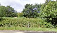
[[File:{{#var:Pnimage}}|thumb|right|500px|This area on the west side of Eversley Road was known as Robin Wood Ground in the mid-19th century / Google Earth Street View]] | [[File:{{#var:Pnimage}}|thumb|right|500px|This area on the west side of Eversley Road was known as Robin Wood Ground in the mid-19th century / Google Earth Street View]] | ||
<p id="byline">By Henrik Thiil Nielsen, 2018-09-20. Revised by {{#realname:{{REVISIONUSER}}}}, {{REVISIONYEAR}}-{{REVISIONMONTH}}-{{REVISIONDAY2}}.</p><div class="no-img">"Robin Wood Ground" was the mid-19th century local name for an area in Arborfield lying immediately west of Eversley Road (A327), a thoroughfare which did not exist at the time. | <p id="byline">By Henrik Thiil Nielsen, 2018-09-20. Revised by {{#realname:{{REVISIONUSER}}}}, {{REVISIONYEAR}}-{{REVISIONMONTH}}-{{REVISIONDAY2}}.</p><div class="no-img">"Robin Wood Ground" was the mid-19th century local name for an area in Arborfield lying immediately west of Eversley Road (A327), a thoroughfare which did not exist at the time. | ||
The name is recorded in the tithe award for Arborfield (1841), where Robin Wood Ground is listed with Henry Simonds, Esq., as owner, Charles Goodechild as occupier, state of cultivation as "Arable", and with an area of 9 acres, 1 rood and 5 perches ({{AcreRoodPerchToM2|9|1|5}} m<sup>2</sup>).<ref>1841 tithe award for Arborfield parish, online at the Genealogist.co.uk, piece 02, sub-piece 007, image 012, Plot No. 284 (subscription required).</ref> An adjacent area known as [[Robin Hood's Coppice (Arborfield)|Robin Hood's Coppice]] already in 1839 is currently known as Robinhood Copse. In view of this there can be little doubt that, whether or not it originated as such, the name "Robin Wood ground" was regarded as referring to Robin Hood.<ref>This is also implied in {{:Gelling, Margaret 1973a}}, pt. I, p. 124.</ref>{{PnItemQry}} | The name is recorded in the tithe award for Arborfield (1841), where Robin Wood Ground is listed with Henry Simonds, Esq., as owner, Charles Goodechild as occupier, state of cultivation as "Arable", and with an area of 9 acres, 1 rood and 5 perches ({{AcreRoodPerchToM2|9|1|5}} m<sup>2</sup>).<ref>1841 tithe award for Arborfield parish, online at the Genealogist.co.uk, piece 02, sub-piece 007, image 012, Plot No. 284 (subscription required).</ref> An adjacent area known as [[Robin Hood's Coppice (Arborfield)|Robin Hood's Coppice]] already in 1839 is currently known as Robinhood Copse. In view of this there can be little doubt that, whether or not it originated as such, the name "Robin Wood ground" was regarded as referring to Robin Hood.<ref>This is also implied in {{:Gelling, Margaret 1973a}}, pt. I, p. 124.</ref>{{PnItemQry}} | ||
Revision as of 10:53, 30 May 2019
[[File:|thumb|right|500px|This area on the west side of Eversley Road was known as Robin Wood Ground in the mid-19th century / Google Earth Street View]]
By Henrik Thiil Nielsen, 2018-09-20. Revised by Henrik Thiil Nielsen, 2019-05-30.
The name is recorded in the tithe award for Arborfield (1841), where Robin Wood Ground is listed with Henry Simonds, Esq., as owner, Charles Goodechild as occupier, state of cultivation as "Arable", and with an area of 9 acres, 1 rood and 5 perches (Template:AcreRoodPerchToM2 m2).[1] An adjacent area known as Robin Hood's Coppice already in 1839 is currently known as Robinhood Copse. In view of this there can be little doubt that, whether or not it originated as such, the name "Robin Wood ground" was regarded as referring to Robin Hood.[2]Template:PnItemQry
Gazetteers
- Not included in Dobson, R. B., ed.; Taylor, J., ed. Rymes of Robyn Hood: an Introduction to the English Outlaw (London, 1976), pp. 315-19.
MS sources
- 1839 tithe map for Arborfield parish, online at the Genealogist.co.uk, piece 02, sub-piece 007, sub-image 001 (subscription required). (Robin Wood ground not labelled).
- 1841 tithe award for Arborfield parish, online at the Genealogist.co.uk, piece 02, sub-piece 007, image 012, Plot No. 286 (subscription required).
Printed and web sources
- Gelling, Margaret. The Place-Names of Berkshire (English Place-Name Society, vols. XLIX-LI) (Cambridge, 1973; [s.l.], 1974-76), pt. I, p. 124 (and see p. 123 for parish).
Maps
These maps show the area, but Robin Wood Ground is not indicated or labelled on them.
- 25" O.S. map Berkshire XLVI.5 (c. 1875; surveyed 1871). (No Copy in NLS)
- 25" O.S. map Berkshire XLVI.5 (c. 1899; rev. c. 1898). (No Copy in NLS)
- 25" O.S. map Berkshire XLVI.5 (1911; rev. 1910)
- 25" O.S. map Berkshire XLVI.5 (1911; rev. 1910) (georeferenced)
- 25" O.S. map Berkshire XLVI.5 (1933; rev. 1932)
- 6" O.S. map Berkshire XLVI (1876; surveyed 1871-72)
- 6" O.S. map Berkshire XLVI.NW (1900; rev. 1899) (georeferenced)
- 6" O.S. map Berkshire XLVI.NW (1900; rev. 1899)
- 6" O.S. map Berkshire XLVI.NW (1912; rev. 1910)
- 6" O.S. map Berkshire XLVI.NW (c. 1934; rev. 1932)
- 6" O.S. map Berkshire XLVI.NW (c. 1944; rev. 1938).
Notes
- ↑ 1841 tithe award for Arborfield parish, online at the Genealogist.co.uk, piece 02, sub-piece 007, image 012, Plot No. 284 (subscription required).
- ↑ This is also implied in Gelling, Margaret. The Place-Names of Berkshire (English Place-Name Society, vols. XLIX-LI) (Cambridge, 1973; [s.l.], 1974-76), pt. I, p. 124.
This area on the west side of Eversley Road was known as Robin Wood Ground in the mid-19th century / Google Earth Street View
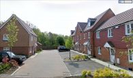
Looking south from Poperinghe Way. The area beyond the fence was known as Robin Wood Ground in the mid-19th century / Google Earth Street View

