
Robin Wood's Rock (Beadnell Bay)

By Henrik Thiil Nielsen, 2017-05-09. Revised by Henrik Thiil Nielsen, 2019-04-05.
Robin Wood's Rock is a whin point in the North Sea, c. 480 meters from the coast at high tide, c. 140 meters at low tide, in Beadnell Bay, Northumberland. As Dobson & Taylor note, 'Wood' was a not uncommon alternative for 'Hood' in the 17th and 18th centuries.[1] A standard work on the coastal geography of England and Wales cites the name of this locality as 'Robin Hood's Rock'.[2] So far the earliest is the 6" O.S. map of the area published in 1886 (see Maps section below).
For other examples of 'Wood' for 'Hood', see the page on Wood for Hood.Template:PnItemQry
Gazetteers
- Dobson, R. B., ed.; Taylor, J., ed. Rymes of Robyn Hood: an Introduction to the English Outlaw (London, 1976), p. 300, s.n. Robin Hood's Rock.
Sources
Maps
- 6" O.S. map Northumberland XXII (1866; surveyed 1860)
- 6" O.S. map Northumberland XXII.SE (1899; rev. 1896)
- 6" O.S. map Northumberland XXII.SE (1899; rev. 1896) (georeferenced)
- 6" O.S. map Northumberland nXVIII.SE (1925; rev. 1922)
Background
Notes
- ↑ Dobson, R. B., ed.; Taylor, J., ed. Rymes of Robyn Hood: an Introduction to the English Outlaw (London, 1976), p. 300, s.n. Robin Hood's Rock.
- ↑ Steers, J.A. The Coastline of England and Wales (Cambridge, 1946), p. 454.
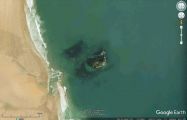
Robin Wood's Rock from the air / Google Earth Street View.
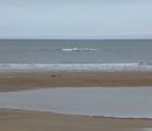
Robin Wood's Rock partly exposed by the ebbing tide / Russel Wills, Creative Commons via Geograph.
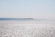
Robin Wood's Rock fully exposed by the low tide / N. Chadwick, Creative Commons via Geograph.

