
Robin How (Luccombe): Difference between revisions
m (Text replacement - "|service=leaflet}}" to "|service=leaflet|enablefullscreen=yes}}") |
m (Text replacement - "Creative Commons via Geograph" to "Creative Commons, via Geograph") |
||
| Line 1: | Line 1: | ||
__NOTOC__{{PnItemTop|Lat=51.173278|Lon=-3.563963|AdmDiv=Somerset|Vicinity=On Dunkery Hill, ''c.'' 2 km SSW of Luccombe|Type=Prehistoric site|Interest=Robin Hood name|Status=Extant|Demonym=|Riding=|GreaterLondon=|Year=1889|Aka=|Century=|Cluster1=Dunkery Hill|Cluster2=|Cluster3=|Image=robin-how-roger-cornfoot-geograph.jpg|Postcards=|ExtraCat1=|ExtraCat2=|ExtraCat3=|ExtraCat4=|ExtraCat5=|ExtraLink1=|ExtraLink2=|ExtraLink3=|ExtraLink4=|ExtraLink5=|ExtraLinkName1=|ExtraLinkName2=|ExtraLinkName3=|ExtraLinkName4=|ExtraLinkName5=|GeopointPrefix=|GeopointSuffix=|StatusSuffix=|DatePrefix=|DateSuffix=}} | __NOTOC__{{PnItemTop|Lat=51.173278|Lon=-3.563963|AdmDiv=Somerset|Vicinity=On Dunkery Hill, ''c.'' 2 km SSW of Luccombe|Type=Prehistoric site|Interest=Robin Hood name|Status=Extant|Demonym=|Riding=|GreaterLondon=|Year=1889|Aka=|Century=|Cluster1=Dunkery Hill|Cluster2=|Cluster3=|Image=robin-how-roger-cornfoot-geograph.jpg|Postcards=|ExtraCat1=|ExtraCat2=|ExtraCat3=|ExtraCat4=|ExtraCat5=|ExtraLink1=|ExtraLink2=|ExtraLink3=|ExtraLink4=|ExtraLink5=|ExtraLinkName1=|ExtraLinkName2=|ExtraLinkName3=|ExtraLinkName4=|ExtraLinkName5=|GeopointPrefix=|GeopointSuffix=|StatusSuffix=|DatePrefix=|DateSuffix=}} | ||
{{#display_map:{{#var:Coords}}~{{#replace:{{PAGENAME}}|'|'}}|width=34%|service=leaflet|enablefullscreen=yes}}<div class="pnMapLegend">Robin How.</div> | {{#display_map:{{#var:Coords}}~{{#replace:{{PAGENAME}}|'|'}}|width=34%|service=leaflet|enablefullscreen=yes}}<div class="pnMapLegend">Robin How.</div> | ||
[[File:robin-how-roger-cornfoot-geograph.jpg|thumb|right|500px|The cairn on Robin How / [http://www.geograph.org.uk/photo/2561893 Roger Cornfoot,19 Aug. 2011, Creative Commons via Geograph.]]] | [[File:robin-how-roger-cornfoot-geograph.jpg|thumb|right|500px|The cairn on Robin How / [http://www.geograph.org.uk/photo/2561893 Roger Cornfoot,19 Aug. 2011, Creative Commons, via Geograph.]]] | ||
<p id="byline">By Henrik Thiil Nielsen, 2017-09-15. Revised by {{#realname:{{REVISIONUSER}}}}, {{REVISIONYEAR}}-{{REVISIONMONTH}}-{{REVISIONDAY2}}.</p> | <p id="byline">By Henrik Thiil Nielsen, 2017-09-15. Revised by {{#realname:{{REVISIONUSER}}}}, {{REVISIONYEAR}}-{{REVISIONMONTH}}-{{REVISIONDAY2}}.</p> | ||
<div class="no-img"> | <div class="no-img"> | ||
| Line 34: | Line 34: | ||
{{ImgGalleryIntro}} | {{ImgGalleryIntro}} | ||
<gallery widths="195px"> | <gallery widths="195px"> | ||
File:robin-how-roger-cornfoot-geograph.jpg|The cairn on Robin How / [http://www.geograph.org.uk/photo/2561893 Roger Cornfoot,19 Aug. 2011, Creative Commons via Geograph.] | File:robin-how-roger-cornfoot-geograph.jpg|The cairn on Robin How / [http://www.geograph.org.uk/photo/2561893 Roger Cornfoot,19 Aug. 2011, Creative Commons, via Geograph.] | ||
File:robin-how-martin-bodman-geograph.jpg|Robin How Cairn. Looking east-north-east from Dunkery Hill / [http://www.geograph.org.uk/photo/216932 Martin Bodman, 9 Aug. 2006, Creative Commons via Geograph.] | File:robin-how-martin-bodman-geograph.jpg|Robin How Cairn. Looking east-north-east from Dunkery Hill / [http://www.geograph.org.uk/photo/216932 Martin Bodman, 9 Aug. 2006, Creative Commons, via Geograph.] | ||
File:robin-how-somerset-google-earth.jpg|thumb|right|500px|Three grey dots at centre, from top: Joaney How, Robin How, and an unnamed mound / Google Earth Street View. (Click to enlarge). | File:robin-how-somerset-google-earth.jpg|thumb|right|500px|Three grey dots at centre, from top: Joaney How, Robin How, and an unnamed mound / Google Earth Street View. (Click to enlarge). | ||
</gallery> | </gallery> | ||
Revision as of 11:23, 30 May 2019

By Henrik Thiil Nielsen, 2017-09-15. Revised by Henrik Thiil Nielsen, 2019-05-30.
Robin How is a large Bronze Age cairn on Dunkery Hill. On the how, a circular mound of stone enclosed by a heather and turf covered bank, c. 21.5 m in diameter and more than 2 metres high, two conical tops were formerly found, one to the north, the other to the south, each about 1 m in height. These have been levelled at a relatively recent date.[1] One or more of the quarry pits found in the immediate vicinity may have provided the material for the mound.
Robin How and Joaney How, a little to the northeast, together with their unnamed southern neighbour (see Google aerial photo on this page) used to be referred to collectively as Luckham Barrows. The earliest source to include the names 'Robin How' and 'Joaney How' found so far is the 6" O.S. map from 1889 listed in the Maps section below.[1] Apparently there is a tradition to the effect that Robin How and Joaney How are named after Robin Hood and Little John.[2] Template:PnItemQry
Gazetteers
- Not included in Dobson, R. B., ed.; Taylor, J., ed. Rymes of Robyn Hood: an Introduction to the English Outlaw (London, 1976), pp. 293-311.
Sources
- Historic England: Round cairn cemetery on Dunkery Hill
- PastScape: Robin How
- Exmoor National Park: MSO6251 - Robin How Cairn on Dunkery Hill.
Maps
- 6" O.S. map Somerset XXXIV.SW (1889; surveyed 1888)
- 6" O.S. map Somerset XXXIV.SW (1903; rev. 1902)
- 6" O.S. map Somerset XXXIV.SW (1903; rev. 1902) (georeferenced)
- 6" O.S. map Somerset XXXIV.SW (1930; rev. 1928).
Background
- Gray, H. St. G., 'Rude stone monuments of Exmoor', Somerset Archaeology and Natural History: the Proceedings of the Somersetshire Archaeological and Natural History Society, vol. 78 (1932), pp.121-25, see pp. 124-25. Not seen, but cf. PastScape.
- Grinsell, L.V., 'Somerset Barrows Part 1: West and South', Somerset Archaeology and Natural History: the Proceedings of the Somersetshire Archaeological and Natural History Society, vol. 113 (1968-69) pp. 1-43., see pp. 14, 15, 17, 35, 43. Not seen, but cf. PastScape.
- Modern Antiquarian: Dunkery Hill Barrows
- Wikipedia: Dunkery Hill.
Notes
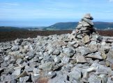
The cairn on Robin How / Roger Cornfoot,19 Aug. 2011, Creative Commons, via Geograph.
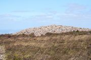
Robin How Cairn. Looking east-north-east from Dunkery Hill / Martin Bodman, 9 Aug. 2006, Creative Commons, via Geograph.
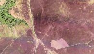
Three grey dots at centre, from top: Joaney How, Robin How, and an unnamed mound / Google Earth Street View. (Click to enlarge).

