
Robin Hood and Little John (Tonwell): Difference between revisions
mNo edit summary |
m (Text replacement - "|width=34%}}" to "|width=34%|fullscreen=yes}}") |
||
| Line 1: | Line 1: | ||
__NOTOC__{{PnItemTop|Lat=51.837451|Lon=-0.065235|AdmDiv=Hertfordshire|Vicinity=On Ware Road, Tonwell, Ware|Type=Public house|Interest=Robin Hood name| | __NOTOC__{{PnItemTop|Lat=51.837451|Lon=-0.065235|AdmDiv=Hertfordshire|Vicinity=On Ware Road, Tonwell, Ware|Type=Public house|Interest=Robin Hood name| | ||
Status=Extant|Demonym=|Riding=|GreaterLondon=|Year=1851|Aka=Robin Hood & Little John; Little John; Robin Hood|Century=|Cluster1=|Cluster2=|Cluster3=|Image=geograph-3767110-by-Bikeboy.jpg|Postcards=|ExtraCat1=|ExtraCat2=|ExtraCat3=|ExtraCat4=|ExtraCat5=|ExtraLink1=|ExtraLink2=|ExtraLink3=|ExtraLink4=|ExtraLink5=|ExtraLinkName1=|ExtraLinkName2=|ExtraLinkName3=|ExtraLinkName4=|ExtraLinkName5=|GeopointPrefix=|GeopointSuffix=|VicinitySuffix=|StatusSuffix=|DatePrefix=|DateSuffix=}} | Status=Extant|Demonym=|Riding=|GreaterLondon=|Year=1851|Aka=Robin Hood & Little John; Little John; Robin Hood|Century=|Cluster1=|Cluster2=|Cluster3=|Image=geograph-3767110-by-Bikeboy.jpg|Postcards=|ExtraCat1=|ExtraCat2=|ExtraCat3=|ExtraCat4=|ExtraCat5=|ExtraLink1=|ExtraLink2=|ExtraLink3=|ExtraLink4=|ExtraLink5=|ExtraLinkName1=|ExtraLinkName2=|ExtraLinkName3=|ExtraLinkName4=|ExtraLinkName5=|GeopointPrefix=|GeopointSuffix=|VicinitySuffix=|StatusSuffix=|DatePrefix=|DateSuffix=}} | ||
{{#display_map:{{#var:Coords}}~{{#replace:{{PAGENAME}}|'|'}}|width=34%}}<div class="pnMapLegend">The Robin Hood & Little John.</div> | {{#display_map:{{#var:Coords}}~{{#replace:{{PAGENAME}}|'|'}}|width=34%|fullscreen=yes}}<div class="pnMapLegend">The Robin Hood & Little John.</div> | ||
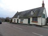
[[File:{{#var:Pnimage}}|thumb|right|500px|Robin Hood and Little John pub, Tonwell / [https://m.geograph.org.uk/photo/3767110 Bikeboy, 02 Dec. 2013, Creative Commons, via Geograph.]]] | [[File:{{#var:Pnimage}}|thumb|right|500px|Robin Hood and Little John pub, Tonwell / [https://m.geograph.org.uk/photo/3767110 Bikeboy, 02 Dec. 2013, Creative Commons, via Geograph.]]] | ||
<p id="byline">By Henrik Thiil Nielsen, 2020-09-01. Revised by {{#realname:{{REVISIONUSER}}}}, {{REVISIONYEAR}}-{{REVISIONMONTH}}-{{REVISIONDAY2}}.</p><div class="no-img"> | <p id="byline">By Henrik Thiil Nielsen, 2020-09-01. Revised by {{#realname:{{REVISIONUSER}}}}, {{REVISIONYEAR}}-{{REVISIONMONTH}}-{{REVISIONDAY2}}.</p><div class="no-img"> | ||
Revision as of 10:25, 22 December 2020
[[File:|thumb|right|500px|Robin Hood and Little John pub, Tonwell / Bikeboy, 02 Dec. 2013, Creative Commons, via Geograph.]]
By Henrik Thiil Nielsen, 2020-09-01. Revised by Henrik Thiil Nielsen, 2020-12-22.
The still existing Robin Hood & Little John on Ware Road in Tonwell, Ware. Hertfordshire, was in business by 1851.
The excellent Pub Wiki provides a wealth of information on publicans etc. for the years 1851–1937.[1] Template:PnItemQry
Gazetteers
- Not included in Dobson, R. B., ed.; Taylor, J., ed. Rymes of Robyn Hood: an Introduction to the English Outlaw (London, 1976), pp. 293-311.
Sources
Maps
- 25" O.S. map Hertfordshire XXIX.3 (c. 1881; surveyed 1880). No copy in NLS
- 25" O.S. map Hertfordshire XXIX.3 (1898; rev. 1897) (georeferenced)
- 25" O.S. map Hertfordshire XXIX.3 (1898; rev. 1897)
- 25" O.S. map Hertfordshire XXIX.3 (1923; rev. 1922)
- 6" O.S. map Hertfordshire XXIX (1884; surveyed 1879–80)
- 6" O.S. map Hertfordshire XXIX.NE (1899; rev. 1896–97) (georeferenced)
- 6" O.S. map Hertfordshire XXIX.NE (1899; rev. 1896–97)
- 6" O.S. map Hertfordshire XXIX.NE (1925; rev. 1922)
- 6" O.S. map Hertfordshire XXIX.NE (c. 1949; rev. 1938)
- 6" O.S. map Hertfordshire XXIX.NE (c. 1950; rev. 1938–46).
Background
Notes
Robin Hood and Little John pub, Tonwell / Bikeboy, 2 Dec. 2013, Creative Commons, via Geograph.
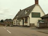
Robin Hood & Little John public house at Tonwell / Robert Edwards, 8 June 2009, Creative Commons, via Geograph.
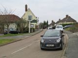
Tonwell: Ware Road and The Robin Hood and Little John / John Sutton, 14 Jan. 2018, Creative Commons, via Geograph.


