
Robin Hood and Little John (Rabley Heath): Difference between revisions
mNo edit summary |
m (→Maps) |
||
| Line 11: | Line 11: | ||
== Maps == | == Maps == | ||
* 25" O.S. map ''Hertfordshire XX.11 (''c.'' 1881; surveyed 1879-80). No Copy in NLS | |||
* 25" O.S. map ''Hertfordshire XX.11 (''c.'' 1898; rev. ''c.''. 1897). No Copy in NLS | |||
* [https://maps.nls.uk/geo/explore/#zoom=17&lat=51.8573&lon=-0.2074&layers=168&b=5 25" O.S. map ''Hertfordshire'' XX.11 (1924; rev. 1922)] (georeferenced) | |||
* [https://maps.nls.uk/view/104200036#zoom=4&lat=1918&lon=11729&layers=BT 25" O.S. map ''Hertfordshire'' XX.11 (1924; rev. 1922)] | |||
* [https://maps.nls.uk/view/104200033#zoom=4&lat=2238&lon=10677&layers=BT 25" O.S. map ''Hertfordshire'' XX.11 (1946; rev. 1939)] | |||
* [http://maps.nls.uk/view/102343301#zoom=6&lat=3669&lon=11023&layers=BT 6" O.S. map ''Hertfordshire'' XX (1884; surveyed 1881)] | * [http://maps.nls.uk/view/102343301#zoom=6&lat=3669&lon=11023&layers=BT 6" O.S. map ''Hertfordshire'' XX (1884; surveyed 1881)] | ||
* [https://maps.nls.uk/geo/explore/#zoom=16&lat=51.8579&lon=-0.2083&layers=6&b=5 6" O.S. map ''Hertfordshire'' XX.SE (1899; rev. 1897)] (georeferenced) | |||
* [http://maps.nls.uk/view/101579214#zoom=5&lat=3807&lon=3502&layers=BT 6" O.S. map ''Hertfordshire'' XX.SE (1899; rev. 1897)] | * [http://maps.nls.uk/view/101579214#zoom=5&lat=3807&lon=3502&layers=BT 6" O.S. map ''Hertfordshire'' XX.SE (1899; rev. 1897)] | ||
* [http://maps.nls.uk/view/101579211#zoom=5&lat=4129&lon=3610&layers=BT 6" O.S. map ''Hertfordshire'' XX.SE (1925; rev. 1922)] | * [http://maps.nls.uk/view/101579211#zoom=5&lat=4129&lon=3610&layers=BT 6" O.S. map ''Hertfordshire'' XX.SE (1925; rev. 1922)] | ||
Revision as of 17:40, 19 October 2018
[[File:|thumb|right|500px|Robin Hood and Little John / Robert Edwards, 16 May 2009, Creative Commons via Geograph.]]
By Henrik Thiil Nielsen, 2013-08-07. Revised by Henrik Thiil Nielsen, 2014-07-24.
The Robin Hood and Little John, a pub and restaurant in Rabley Heath, Welwyn, Hertfordshire, was in existence by 1871.[1]
The earliest map reference is a 6" O.S. map published in 1884, based on surveying carried out in 1881 (see Maps below). Information on publicans for the years 1871 to 1937 can be found at UK Pub History.[2] Template:PnItemQry
Gazetteers
- Not included in Dobson, R. B., ed.; Taylor, J., ed. Rymes of Robyn Hood: an Introduction to the English Outlaw (London, 1976), pp. 293-311.
Maps
- 25" O.S. map Hertfordshire XX.11 (c. 1881; surveyed 1879-80). No Copy in NLS
- 25" O.S. map Hertfordshire XX.11 (c. 1898; rev. c.. 1897). No Copy in NLS
- 25" O.S. map Hertfordshire XX.11 (1924; rev. 1922) (georeferenced)
- 25" O.S. map Hertfordshire XX.11 (1924; rev. 1922)
- 25" O.S. map Hertfordshire XX.11 (1946; rev. 1939)
- 6" O.S. map Hertfordshire XX (1884; surveyed 1881)
- 6" O.S. map Hertfordshire XX.SE (1899; rev. 1897) (georeferenced)
- 6" O.S. map Hertfordshire XX.SE (1899; rev. 1897)
- 6" O.S. map Hertfordshire XX.SE (1925; rev. 1922)
- 6" O.S. map Hertfordshire XX.SE (1950; rev. 1946-47).
Sources
Background
Notes
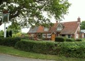
Robin Hood and Little John / Robert Edwards, 16 May 2009, Creative Commons via Geograph.
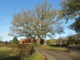
Oak tree at the Robin Hood and Little John Public House. This magnificent oak tree dwarfs the mainly single storey public house / Nigel Cox, 22 Nov. 2015, Creative Commons via Geograph.
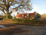
Robin Hood and Little John, a Grade II listed building / Nigel Cox, 22 Nov. 2015, Creative Commons via Geograph.


