
Robin Hood and Little John (Poplar): Difference between revisions
m (→Maps) |
m (→Maps) |
||
| Line 26: | Line 26: | ||
* [https://maps.nls.uk/view/101456111#zoom=5&lat=5071&lon=6364&layers=BT 6" O.S. map ''Essex'' LXXXI.NW (1899; rev. 1893-94)] | * [https://maps.nls.uk/view/101456111#zoom=5&lat=5071&lon=6364&layers=BT 6" O.S. map ''Essex'' LXXXI.NW (1899; rev. 1893-94)] | ||
* [https://maps.nls.uk/view/101427837#zoom=5&lat=4646&lon=5402&layers=BT 6" O.S. map ''Kent'' I.NE (1899; rev. 1893-94)] | * [https://maps.nls.uk/view/101427837#zoom=5&lat=4646&lon=5402&layers=BT 6" O.S. map ''Kent'' I.NE (1899; rev. 1893-94)] | ||
* [http://maps.nls.uk/geo/explore/#zoom=17&lat=51.5105&lon=-0.0075&layers=6&b=1 6" O.S. map 'Kent' I.NE (1899; rev. 1893-94)] (georeferenced) | * [http://maps.nls.uk/geo/explore/#zoom=17&lat=51.5105&lon=-0.0075&layers=6&b=1 6" O.S. map 'Kent' I.NE (1899; rev. 1893-94)] (georeferenced) | ||
* [https://maps.nls.uk/view/102345870#zoom=6&lat=3974&lon=1908&layers=BT 6" O.S. map ''London'' Sheet L (1920; rev. 1913-15)] | * [https://maps.nls.uk/view/102345870#zoom=6&lat=3974&lon=1908&layers=BT 6" O.S. map ''London'' Sheet L (1920; rev. 1913-15)] | ||
* [https://maps.nls.uk/view/102345867#zoom=6&lat=4060&lon=2243&layers=BT 6" O.S. map ''London'' Sheet L (''c.'' 1946; rev. 1938).] | * [https://maps.nls.uk/view/102345867#zoom=6&lat=4060&lon=2243&layers=BT 6" O.S. map ''London'' Sheet L (''c.'' 1946; rev. 1938).] | ||
Revision as of 17:09, 31 May 2019
[[File:|thumb|right|500px|Robin Hood Lane where the pub was most probably located / Google Earth Street View.]]
By Henrik Thiil Nielsen, 2018-06-14. Revised by Henrik Thiil Nielsen, 2019-05-31.
The Robin Hood and Little John, also known as the Robinhood, was located somewhere in or quite close to Robin Hood Lane, Poplar. It is mentioned in summaries of cases at the Old Bailey in 1841 and 1876.
From the report of the case in 1841 (see Records below) we can conclude only that the Robin Hood and Little John beer shop (pub) must have been located in or close to Poplar, but if we make the reasonable assumption that the pub was also known as 'the Robinhood', the 1876 case helps us place it in (the vicinity of) Robin Hood Lane, Poplar. A policeman near "the Robinhood, Poplar" sees a man – soon to become the victim of assault and robbery – walking by in the company of another and followed at a short distance by two more who will soon attack him. On his way home from the Iron Bridge pub on what was then known as Barking Road but is now 447 East India Dock Road,[1] he is followed by these two characters who he rightly judges to have evil intentions, so he stops for a while at the shop of a Mr. Forsyth, who eventually walks with him, armed with a truncheon, to the lower end of Robin Hood Lane, from which point the victim proceeds alone to his home. According to the victim, the distance from Mr Forsyth's shop to his home is 600 or 700 yards (s. 550 to 650 m). At present Robin Hood Lane is about 250 m long, and the distance from the point where it meets Poplar High Street to the victims house at No. 278 is a further c. 175 m. Based on these figures, Mr Forsyth's premises must have been at East India Dock Road, 125 to 225 meters east of the point where it meets Robin Hood Lane. The Robin Hood pub was therefore on East India Dock Road or in Robin Hood Lane, and the name of course makes the latter the best choice.Template:PnItemQry
Gazetteers
- Not included in Dobson, R. B., ed.; Taylor, J., ed. Rymes of Robyn Hood: an Introduction to the English Outlaw (London, 1976), pp. 293-311.
Maps
- Gascoyne, Joel, cartog.; Harris, John, engr. An Actuall Survey of the Parish of St Dunstan Stepney alias Stebunheath ([London], 1703)
- Gascoyne, Joel, cartog.; Harris, John, engr. An Actuall Survey of the Parish of St. Dunstan Stepney, Alias Stebunheath: Being One of the Ten Paryshes in the County of Middlesex Adjacent to the City of London ([London], [1994?])
- British Library: Online Gallery; section, including Robin Hood Lane, as an overlay on Google Maps
- Daniel Crouch Rare Books Eastenders; entire map (reduced size)
- 25" O.S. map London (1869; surveyed 1867)
- 25" O.S. map Essex (1916; rev. 1914)
- 25" O.S. map Essex LXXXVI.9 (1916; rev. 1914) (georeferenced)
- 6" O.S. map Essex LXXXI (1870-82; surveyed 1862-73)
- 6" O.S. map Middlesex XVIII (1873; surveyed 1867)
- 6" O.S. map Surrey III (1880; surveyed 1868-73)
- 6" O.S. map London VIII.SW (1894-96; rev. 1893-94)
- 6" O.S. map Surrey III.NE (1898; rev. 1893-94)
- 6" O.S. map Essex LXXXI.NW (1899; rev. 1893-94)
- 6" O.S. map Kent I.NE (1899; rev. 1893-94)
- 6" O.S. map 'Kent' I.NE (1899; rev. 1893-94) (georeferenced)
- 6" O.S. map London Sheet L (1920; rev. 1913-15)
- 6" O.S. map London Sheet L (c. 1946; rev. 1938).
Background
- British History Online: East India Dock Road: Introduction, from Survey of London, vols. 43-44, Poplar, Blackwall and Isle of Dogs. Originally published by London County Council, London, 1994
- UK Pub History: Iron Bridge Tavern, 447 East India Dock Road, Bromley E14.
Notes
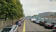
Robin Hood Lane where the pub was most probably located / Google Earth Street View.
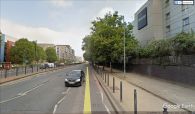
East India Dock Road, the most likely alternative location / Google Earth Street View.

