
Robin Hood Wood (Bassenthwaite): Difference between revisions
From International Robin Hood Bibliography
m (Text replacement - "AdmDiv" to "AdministrativeDivision") |
m (Text replacement - "PnItemTop" to "PlaceNamesItemTop") |
||
| Line 1: | Line 1: | ||
__NOTOC__{{ | __NOTOC__{{PlaceNamesItemTop|Lat=54.6825|Lon=-3.1958|AdministrativeDivision=Cumberland|Vicinity=Immediately N of Bassenthwaite|Type=Natural feature|Interest=Robin Hood name|Status=Extant|Demonym=|Riding=|GreaterLondon=|Year=1867|Aka=Robin Wood|Century=|Cluster1=Bassenthwaite|Cluster2=|Cluster3=|Image=robin-hhod-wood-david-brown-geograph.jpg|Postcards=|ExtraCat1=Places named Robin Hood's Wood|ExtraCat2=|ExtraCat3=|ExtraCat4=|ExtraCat5=|ExtraLink1=|ExtraLink2=|ExtraLink3=|ExtraLink4=|ExtraLink5=|ExtraLinkName1=|ExtraLinkName2=|ExtraLinkName3=|ExtraLinkName4=|ExtraLinkName5=|GeopointPrefix=|GeopointSuffix=|StatusSuffix=|DatePrefix=|DateSuffix=}} | ||
{{#display_map:{{#var:Coords}}~{{#replace:{{PAGENAME}}|'|'}}|width=34%|enablefullscreen=yes}}<div class="pnMapLegend">Robin Hood Wood.</div> | {{#display_map:{{#var:Coords}}~{{#replace:{{PAGENAME}}|'|'}}|width=34%|enablefullscreen=yes}}<div class="pnMapLegend">Robin Hood Wood.</div> | ||
[[File:robin-hhod-wood-david-brown-geograph.jpg|thumb|right|500px|Path in Robin Hood Wood / [http://www.geograph.org.uk/photo/4293756 David Brown; Geograph; Creative Commons.]]]<div class="no-img"> | [[File:robin-hhod-wood-david-brown-geograph.jpg|thumb|right|500px|Path in Robin Hood Wood / [http://www.geograph.org.uk/photo/4293756 David Brown; Geograph; Creative Commons.]]]<div class="no-img"> | ||
Revision as of 00:04, 6 January 2021
| Locality | |
|---|---|
| Coordinate | 54.6825, -3.1958 |
| Adm. div. | Cumberland |
| Vicinity | Immediately N of Bassenthwaite |
| Type | Natural feature |
| Interest | Robin Hood name |
| Status | Extant |
| First Record | 1867 |
| A.k.a. | Robin Wood |
Robin Hood Wood.

Path in Robin Hood Wood / David Brown; Geograph; Creative Commons.
By Henrik Thiil Nielsen, 2017-08-30. Revised by Henrik Thiil Nielsen, 2021-01-06.
Robin Hood Wood is situated immediately north of Bassenthwaite. About 200 m NNW are Robin Hood farm and Robin Hood Cottage. Robin Hood Holiday Park is located c. 300 m northwest. Robin Hood Wood is included on the 6" O.S. map of the area published in 1867 as well as subsequent revisions (see Maps section below). Template:PnItemQry
Gazetteers
- Not included in Dobson, R. B., ed.; Taylor, J., ed. Rymes of Robyn Hood: an Introduction to the English Outlaw (London, 1976), pp. 293-311.
Maps
- 6" O.S. map Cumberland XLVI (1867; surveyed 1864-65)
- 6" O.S. map Cumberland XLVI.SE (1900; rev. 1898)
- 6" O.S. map Cumberland XLVI.SE (1900; rev. 1898) (georeferenced)
- 6" O.S. map Cumberland XLVI.SE (19230; rev. 1926).
Background
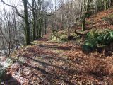
Path in Robin Hood Wood / David Brown; Geograph; Creative Commons.
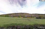
Robin Hood Wood seen from the southwest / Google Earth Street View.
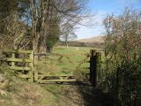
Bridleway in Robin Hood Wood / Adrian Taylor; Geograph; Creative Commons.
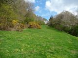
On the bridleway in Robin Hood Wood / Christine Johnstone; Geograph; Creative Commons.


