
Robin Hood Wood (Bassenthwaite): Difference between revisions
From International Robin Hood Bibliography
m (Text replacement - "<h3>Records</h3>" to "<h2>Records</h2>") |
m (Text replacement - "<div class="no-img"><p id="byline">" to "<div class="no-img"> <p id="byline">") |
||
| (12 intermediate revisions by 2 users not shown) | |||
| Line 1: | Line 1: | ||
__NOTOC__{{PnItemTop|Lat=54.6825|Lon=-3.1958|AdmDiv=Cumberland|Vicinity=Immediately N of Bassenthwaite|Type=Natural feature|Interest=Robin Hood name|Status=Extant|Demonym=|Riding=|GreaterLondon=|Year=1867|Aka=|Century=|Cluster1=Bassenthwaite|Cluster2=|Cluster3=|Image=robin-hhod-wood-david-brown-geograph.jpg|Postcards=|ExtraCat1=Places named Robin Hood's Wood|ExtraCat2=|ExtraCat3=|ExtraCat4=|ExtraCat5=|ExtraLink1=|ExtraLink2=|ExtraLink3=|ExtraLink4=|ExtraLink5=|ExtraLinkName1=|ExtraLinkName2=|ExtraLinkName3=|ExtraLinkName4=|ExtraLinkName5=|GeopointPrefix=|GeopointSuffix=|StatusSuffix=|DatePrefix=|DateSuffix=}} | __NOTOC__{{PnItemTop|Lat=54.6825|Lon=-3.1958|AdmDiv=Cumberland|Vicinity=Immediately N of Bassenthwaite|Type=Natural feature|Interest=Robin Hood name|Status=Extant|Demonym=|Riding=|GreaterLondon=|Year=1867|Aka=Robin Wood|Century=|Cluster1=Bassenthwaite|Cluster2=|Cluster3=|Image=robin-hhod-wood-david-brown-geograph.jpg|Postcards=|ExtraCat1=Places named Robin Hood's Wood|ExtraCat2=|ExtraCat3=|ExtraCat4=|ExtraCat5=|ExtraLink1=|ExtraLink2=|ExtraLink3=|ExtraLink4=|ExtraLink5=|ExtraLinkName1=|ExtraLinkName2=|ExtraLinkName3=|ExtraLinkName4=|ExtraLinkName5=|GeopointPrefix=|GeopointSuffix=|StatusSuffix=|DatePrefix=|DateSuffix=}} | ||
{{#display_map:{{#var:Coords}}~{{#replace:{{PAGENAME}}|'|'}}|width=34%}}<div class="pnMapLegend">Robin Hood Wood.</div> | {{#display_map:{{#var:Coords}}~{{#replace:{{PAGENAME}}|'|'}}|width=34%|service=leaflet|enablefullscreen=yes}}<div class="pnMapLegend">Robin Hood Wood.</div> | ||
[[File:robin-hhod-wood-david-brown-geograph.jpg|thumb|right|500px|Path in Robin Hood Wood / [http://www.geograph.org.uk/photo/4293756 David Brown; Geograph; Creative Commons.]]] | [[File:robin-hhod-wood-david-brown-geograph.jpg|thumb|right|500px|Path in Robin Hood Wood / [http://www.geograph.org.uk/photo/4293756 David Brown; Geograph; Creative Commons.]]]<div class="no-img"> | ||
<p id="byline">By Henrik Thiil Nielsen, 2017-08-30. Revised by {{#realname:{{REVISIONUSER}}}}, {{REVISIONYEAR}}-{{REVISIONMONTH}}-{{REVISIONDAY2}}.</p> | <p id="byline">By Henrik Thiil Nielsen, 2017-08-30. Revised by {{#realname:{{REVISIONUSER}}}}, {{REVISIONYEAR}}-{{REVISIONMONTH}}-{{REVISIONDAY2}}.</p> | ||
Robin Hood Wood is situated immediately north of Bassenthwaite. About 200 m NNW are [[Robin Hood (Bassenthwaite)|Robin Hood]] farm and [[Robin Hood Cottage (Bassenthwaite)|Robin Hood Cottage]]. [[Robin Hood Holiday Park (Bassenthwaite)|Robin Hood Holiday Park]] is located ''c.'' 300 m northwest. Robin Hood Wood is included on the 6" O.S. map of the area published in 1867 as well as subsequent revisions (see Maps section below). | Robin Hood Wood is situated immediately north of Bassenthwaite. About 200 m NNW are [[Robin Hood (Bassenthwaite)|Robin Hood]] farm and [[Robin Hood Cottage (Bassenthwaite)|Robin Hood Cottage]]. [[Robin Hood Holiday Park (Bassenthwaite)|Robin Hood Holiday Park]] is located ''c.'' 300 m northwest. Robin Hood Wood is included on the 6" O.S. map of the area published in 1867 as well as subsequent revisions (see Maps section below). | ||
{{ | {{PnItemQry}} | ||
== Gazetteers == | == Gazetteers == | ||
* Not included in {{:Dobson, Richard Barrie 1976a}}, pp. 293-311. | * Not included in {{:Dobson, Richard Barrie 1976a}}, pp. 293-311. | ||
| Line 13: | Line 12: | ||
* [http://maps.nls.uk/view/101091685#zoom=5&lat=2385&lon=7573&layers=BT 6" O.S. map ''Cumberland'' XLVI.SE (1900; rev. 1898)] | * [http://maps.nls.uk/view/101091685#zoom=5&lat=2385&lon=7573&layers=BT 6" O.S. map ''Cumberland'' XLVI.SE (1900; rev. 1898)] | ||
* [http://maps.nls.uk/geo/explore/#zoom=17&lat=54.6836&lon=-3.1997&layers=171&b=1 6" O.S. map ''Cumberland'' XLVI.SE (1900; rev. 1898)] (georeferenced) | * [http://maps.nls.uk/geo/explore/#zoom=17&lat=54.6836&lon=-3.1997&layers=171&b=1 6" O.S. map ''Cumberland'' XLVI.SE (1900; rev. 1898)] (georeferenced) | ||
* [http://maps.nls.uk/view/101091682#zoom=5&lat=2692&lon=7574&layers=BT 6" O.S. map ''Cumberland'' XLVI.SE (19230; rev. 1926)] | * [http://maps.nls.uk/view/101091682#zoom=5&lat=2692&lon=7574&layers=BT 6" O.S. map ''Cumberland'' XLVI.SE (19230; rev. 1926).] | ||
== Background == | == Background == | ||
| Line 20: | Line 19: | ||
== Notes == | == Notes == | ||
<references/>--> | <references/>--> | ||
</div> | |||
< | <div id="gallery"> | ||
{{ImgGalleryIntro}} | {{ImgGalleryIntro}} | ||
<gallery widths="195px"> | <gallery widths="195px"> | ||
| Line 29: | Line 29: | ||
File:robin-hood-wood-bassenthwaite-christine-johnstone-geograph.jpg|On the bridleway in Robin Hood Wood / [http://www.geograph.org.uk/photo/3950822 Christine Johnstone; Geograph; Creative Commons.] | File:robin-hood-wood-bassenthwaite-christine-johnstone-geograph.jpg|On the bridleway in Robin Hood Wood / [http://www.geograph.org.uk/photo/3950822 Christine Johnstone; Geograph; Creative Commons.] | ||
</gallery> | </gallery> | ||
</div> | |||
{{PnItemNav}} | {{PnItemNav}} | ||
Revision as of 04:56, 17 May 2020
Robin Hood Wood.

Path in Robin Hood Wood / David Brown; Geograph; Creative Commons.
By Henrik Thiil Nielsen, 2017-08-30. Revised by Henrik Thiil Nielsen, 2020-05-17.
Robin Hood Wood is situated immediately north of Bassenthwaite. About 200 m NNW are Robin Hood farm and Robin Hood Cottage. Robin Hood Holiday Park is located c. 300 m northwest. Robin Hood Wood is included on the 6" O.S. map of the area published in 1867 as well as subsequent revisions (see Maps section below). Template:PnItemQry
Gazetteers
- Not included in Dobson, R. B., ed.; Taylor, J., ed. Rymes of Robyn Hood: an Introduction to the English Outlaw (London, 1976), pp. 293-311.
Maps
- 6" O.S. map Cumberland XLVI (1867; surveyed 1864-65)
- 6" O.S. map Cumberland XLVI.SE (1900; rev. 1898)
- 6" O.S. map Cumberland XLVI.SE (1900; rev. 1898) (georeferenced)
- 6" O.S. map Cumberland XLVI.SE (19230; rev. 1926).
Background
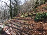
Path in Robin Hood Wood / David Brown; Geograph; Creative Commons.
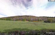
Robin Hood Wood seen from the southwest / Google Earth Street View.
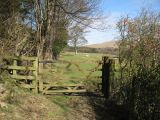
Bridleway in Robin Hood Wood / Adrian Taylor; Geograph; Creative Commons.
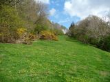
On the bridleway in Robin Hood Wood / Christine Johnstone; Geograph; Creative Commons.


