
Robin Hood Way (Winnersh)
[[File:|thumb|right|500px|Robin Hood Way, Winnersh / Google Maps Street View.]]
By Henrik Thiil Nielsen, 2018-05-28. Revised by Henrik Thiil Nielsen, 2018-06-17.
Robin Hood Way, now a residential street in Winnersh, was part of the original Robinhood Lane, before the course of the latter was changed sometime during the 20th century.
Travelling NNE on Robinhood Lane, just after passing Arbor Lane on the left, one sees on the right an odd-looking arrangement where a bit of metal railing and a narrow foot walk cut across, and block car access to, a side street. This side street is Robin Hood Way, whose present course Robinhood Lane used to follow. To reach the former the motorist must now drive another 50 meters along the latter before turning right. At least as late as 1956, and probably after 1959 (see 1" O.S. maps listed below), Robinhood Lane still followed the old course, but sometime thereafter the course of the road south of Arbor Lane was extended in a straight north-north-easterly line (to become Davis Street after about 500 meters), and direct car access to the old course of the road – now renamed Robin Hood Way – was cut off to ensure that traffic would follow the new course.
Maps
- 25" O.S. map Berkshire XXXVIII.6 (c. 1875; surveyed 1871). No Copy in NLS
- 25" O.S. map Berkshire XXXVIII.6 (1899; rev. 1898)
- 25" O.S. map Berkshire XXXVIII.6 (1899; rev. 1898) (georeferenced)
- 25" O.S. map Berkshire XXXVIII.6 (1912; rev. 1910)
- 25" O.S. map Berkshire XXXVIII.6 (1933; rev. 1932)
- 6" O.S. map Berkshire XXXVIII (1883; surveyed 1871-72)
- 6" O.S. map Berkshire XXXVIII.NW (1900; rev. 1898)
- 6" O.S. map Berkshire XXXVIII.NW (1900; rev. 1898) (georeferenced)
- 6" O.S. map Berkshire XXXVIII.NW (1913; rev. 1910)
- 6" O.S. map Berkshire XXXVIII.NW (c. 1934; rev. 1932)
- 6" O.S. map Berkshire XXXVIII.NW (c. 1944; rev. 1938)
- 1" O.S. New Pop. Ed. Sheet 169 (Hills) (1946).
- 1" O.S. map Aldershot (7th Ser.) (1959; surveyed 1956-59) (georeferenced)
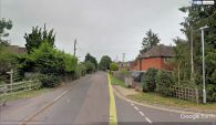
Robin Hood Way, Winnersh / Google Maps Street View.
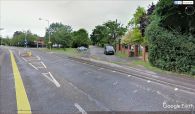
Formerly Robinhood Lane turned NNE here along the course of the present Robin Hood Way, now separated from it by a bit of railing and a narrow foot walk / Google Maps Street View.

