
Robin Hood Roundabout (Kingston-upon-Thames)
From International Robin Hood Bibliography
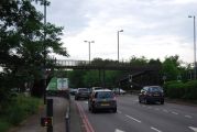
Robin Hood Roundabout, Kingston-upon-Thames
[[File:|thumb|right|500px|Robin Hood Roundabout, Kingston-upon-Thames / Nigel Cox, 30 jan. 2008, Creative Commons via Geograph.]]
By Henrik Thiil Nielsen, 2019-02-23. Revised by Henrik Thiil Nielsen, 2019-02-23.
The Robin Hood Roundabout on the A3 opposite Robin Hood Gate into Richmond Park was established in 1927.[1]
Since 1995 it is no longer possible to drive round it. It is now in simply the junction between the A3 and the A308 (Kingston Vale).[2] Template:PnItemQry
Gazetteers
- Not included in Dobson, R. B., ed.; Taylor, J., ed. Rymes of Robyn Hood: an Introduction to the English Outlaw (London, 1976), pp. 293-311.
Maps
- 6" O.S. map Middlesex XXI (1873; surveyed 1865-66)
- 6" O.S. map Surrey VII (1874; surveyed 1865)
- 6" O.S. map Surrey VII.SW (1899; rev. 1893-95) (georeferenced)
- 6" O.S. map Surrey VII.SW (1899; rev. 1893-95)
- 6" O.S. map Surrey VII.SW (1920; rev. 1911)
- 6" O.S. map Surrey VII.SW (c. 1933; rev. 1911)
- 6" O.S. map Surrey VII.SW (1936; rev. 1932-33)
- 6" O.S. map Surrey VII.SW (c. 1944; rev. 1938)
- 6" O.S. map Surrey VII.SW (c. 1946; rev. 1938).
- 6" O.S. map London X.SW (1894-96; rev. 1893-95)
- 25" O.S. map London (1869; surveyed 1865-67)
- 25" O.S. map Surrey VII.9 (1897; rev. 1894) (georeferenced)
- 25" O.S. map London (1915- Numbered sheets) VIII.14 (1916; rev. 1913) (georeferenced)
- 25" O.S. map London (1916; rev. 1913).

Robin Hood Roundabout, Kingston-upon-Thames / Nigel Cox, 30 jan. 2008, Creative Commons via Geograph.
A3, Robin Hood Roundabout / N. Chadwick, 7 May 2011, Creative Commons via Geograph.

Robin Hood Roundabout / N. Chadwick, 7 May 2011, Creative Commons via Geograph.


- ↑ Geograph: TQ2172 : A3 Robin Hood Roundabout, by Nigel Cox.
- ↑ Geograph: TQ2172 : A3 Robin Hood Roundabout, by Nigel Cox.