
Robin Hood Roundabout (Kingston-upon-Thames): Difference between revisions
mNo edit summary |
m (→Maps) |
||
| (5 intermediate revisions by the same user not shown) | |||
| Line 1: | Line 1: | ||
__NOTOC__{{PnItemTop|Lat=51.435857|Lon=-0.256023|AdmDiv=Surrey|Vicinity=On the A3, opposite Robin Hood Gate into Richmond Park|Type=Thoroughfare|Interest=Robin Hood name|Status=Extant|Demonym=English|Riding=|GreaterLondon=Yes|Year=1927|Aka=Robin Hood Gyratory|Century=|Cluster1=Kingston Vale|Cluster2=|Cluster3=|Image=robin-hood-roundabout-kingston-upon-thames.jpg|Postcards=|ExtraCat1=|ExtraCat2=|ExtraCat3=|ExtraCat4=|ExtraCat5=|ExtraLink1=|ExtraLink2=|ExtraLink3=|ExtraLink4=|ExtraLink5=|ExtraLinkName1=|ExtraLinkName2=|ExtraLinkName3=|ExtraLinkName4=|ExtraLinkName5=|GeopointPrefix=|GeopointSuffix=|StatusSuffix=|DatePrefix=|DateSuffix=}} | __NOTOC__{{PnItemTop|Lat=51.435857|Lon=-0.256023|AdmDiv=Surrey|Vicinity=On the A3, opposite Robin Hood Gate into Richmond Park|Type=Thoroughfare|Interest=Robin Hood name|Status=Extant|Demonym=English|Riding=|GreaterLondon=Yes|Year=1927|Aka=Robin Hood Gyratory|Century=|Cluster1=Kingston Vale|Cluster2=|Cluster3=|Image=robin-hood-roundabout-kingston-upon-thames.jpg|Postcards=|ExtraCat1=|ExtraCat2=|ExtraCat3=|ExtraCat4=|ExtraCat5=|ExtraLink1=|ExtraLink2=|ExtraLink3=|ExtraLink4=|ExtraLink5=|ExtraLinkName1=|ExtraLinkName2=|ExtraLinkName3=|ExtraLinkName4=|ExtraLinkName5=|GeopointPrefix=|GeopointSuffix=|StatusSuffix=|DatePrefix=|DateSuffix=}} | ||
{{#display_map:{{#var:Coords}}~{{#replace:{{PAGENAME}}|'|'}}|width=34%}}<div class="pnMapLegend">Robin Hood Roundabout, Kingston-upon-Thames</div> | {{#display_map:{{#var:Coords}}~{{#replace:{{PAGENAME}}|'|'}}|width=34%|service=leaflet|enablefullscreen=yes}}<div class="pnMapLegend">Robin Hood Roundabout, Kingston-upon-Thames</div> | ||
[[File:{{#var:Pnimage}}|thumb|right|500px|Robin Hood Roundabout, Kingston-upon-Thames / [https://www.geograph.org.uk/photo/675837 Nigel Cox, 30 jan. 2008, Creative Commons via Geograph.]]] | [[File:{{#var:Pnimage}}|thumb|right|500px|Robin Hood Roundabout, Kingston-upon-Thames / [https://www.geograph.org.uk/photo/675837 Nigel Cox, 30 jan. 2008, Creative Commons, via Geograph.]]] | ||
<p id="byline">By Henrik Thiil Nielsen, 2019-02-23. Revised by {{#realname:{{REVISIONUSER}}}}, {{REVISIONYEAR}}-{{REVISIONMONTH}}-{{REVISIONDAY2}}.</p><div class="no-img"> | <p id="byline">By Henrik Thiil Nielsen, 2019-02-23. Revised by {{#realname:{{REVISIONUSER}}}}, {{REVISIONYEAR}}-{{REVISIONMONTH}}-{{REVISIONDAY2}}.</p><div class="no-img"> | ||
The Robin Hood Roundabout on the A3 opposite Robin Hood Gate into Richmond Park was established in 1927.<ref>[https://www.geograph.org.uk/photo/675837 Geograph: TQ2172 : A3 Robin Hood Roundabout], by Nigel Cox.</ref> | The Robin Hood Roundabout on the A3 opposite Robin Hood Gate into Richmond Park was established in 1927.<ref>[https://www.geograph.org.uk/photo/675837 Geograph: TQ2172 : A3 Robin Hood Roundabout], by Nigel Cox.</ref> | ||
| Line 24: | Line 24: | ||
* [https://maps.nls.uk/geo/explore/#zoom=17&lat=51.4373&lon=-0.2582&layers=168&b=5 25" O.S. map ''Surrey'' VII.9 (1897; rev. 1894)] (georeferenced) | * [https://maps.nls.uk/geo/explore/#zoom=17&lat=51.4373&lon=-0.2582&layers=168&b=5 25" O.S. map ''Surrey'' VII.9 (1897; rev. 1894)] (georeferenced) | ||
* [https://maps.nls.uk/geo/explore/#zoom=17&lat=51.4373&lon=-0.2582&layers=168&b=5 25" O.S. map ''London'' (1915- Numbered sheets) VIII.14 (1916; rev. 1913)] (georeferenced) | * [https://maps.nls.uk/geo/explore/#zoom=17&lat=51.4373&lon=-0.2582&layers=168&b=5 25" O.S. map ''London'' (1915- Numbered sheets) VIII.14 (1916; rev. 1913)] (georeferenced) | ||
* [https://maps.nls.uk/view/103313375#zoom=4&lat=2018&lon=3481&layers=BT 25" O.S. map ''London (1916; rev. 1913).] | * [https://maps.nls.uk/view/103313375#zoom=4&lat=2018&lon=3481&layers=BT 25" O.S. map ''London'' (1916; rev. 1913).] | ||
<!--== Discussion == | <!--== Discussion == | ||
== Background == | == Background ==--> | ||
== Brief mention ==- | |||
== Brief mention == | |||
* [https://www.sabre-roads.org.uk/wiki/index.php?title=Robin_Hood_(Kingston) Sabre: Robin Hood (Kingston).] | |||
{{PnItemAlsoSee}} | {{PnItemAlsoSee}} | ||
== Notes == | == Notes == | ||
| Line 35: | Line 37: | ||
{{ImgGalleryIntro}} | {{ImgGalleryIntro}} | ||
<gallery widths="195px"> | <gallery widths="195px"> | ||
File:robin-hood-roundabout-kingston-upon-thames.jpg|Robin Hood Roundabout, Kingston-upon-Thames / [https://www.geograph.org.uk/photo/675837 Nigel Cox, 30 jan. 2008, Creative Commons via Geograph.] | File:robin-hood-roundabout-kingston-upon-thames.jpg|Robin Hood Roundabout, Kingston-upon-Thames / [https://www.geograph.org.uk/photo/675837 Nigel Cox, 30 jan. 2008, Creative Commons, via Geograph.] | ||
File:geograph-2575518-by-N-Chadwick.jpg|A3, Robin Hood Roundabout / [https://www.geograph.org.uk/photo/2575518 N. Chadwick, 7 May 2011, Creative Commons via Geograph.] | File:geograph-2575518-by-N-Chadwick.jpg|A3, Robin Hood Roundabout / [https://www.geograph.org.uk/photo/2575518 N. Chadwick, 7 May 2011, Creative Commons, via Geograph.] | ||
File:geograph-2575532-by-N-Chadwick.jpg|Robin Hood Roundabout / [https://www.geograph.org.uk/photo/2575532 N. Chadwick, 7 May 2011, Creative Commons via Geograph.] | File:geograph-2575532-by-N-Chadwick.jpg|Robin Hood Roundabout / [https://www.geograph.org.uk/photo/2575532 N. Chadwick, 7 May 2011, Creative Commons, via Geograph.] | ||
File:geograph-4184412-by-David-Howard.jpg|Robin Hood Roundabout / [https://www.geograph.org.uk/photo/4184412 David Howard 28 Sep. 2014, Creative Commons, via Geograph.] | |||
</gallery> | </gallery> | ||
{{PnItemNav}} | {{PnItemNav}} | ||
Revision as of 11:59, 7 June 2019
[[File:|thumb|right|500px|Robin Hood Roundabout, Kingston-upon-Thames / Nigel Cox, 30 jan. 2008, Creative Commons, via Geograph.]]
By Henrik Thiil Nielsen, 2019-02-23. Revised by Henrik Thiil Nielsen, 2019-06-07.
The Robin Hood Roundabout on the A3 opposite Robin Hood Gate into Richmond Park was established in 1927.[1]
Since 1995 it is no longer possible to drive round it. It is now in simply the junction between the A3 and the A308 (Kingston Vale).[2] Template:PnItemQry
Gazetteers
- Not included in Dobson, R. B., ed.; Taylor, J., ed. Rymes of Robyn Hood: an Introduction to the English Outlaw (London, 1976), pp. 293-311.
Maps
- 6" O.S. map Middlesex XXI (1873; surveyed 1865-66)
- 6" O.S. map Surrey VII (1874; surveyed 1865)
- 6" O.S. map Surrey VII.SW (1899; rev. 1893-95) (georeferenced)
- 6" O.S. map Surrey VII.SW (1899; rev. 1893-95)
- 6" O.S. map Surrey VII.SW (1920; rev. 1911)
- 6" O.S. map Surrey VII.SW (c. 1933; rev. 1911)
- 6" O.S. map Surrey VII.SW (1936; rev. 1932-33)
- 6" O.S. map Surrey VII.SW (c. 1944; rev. 1938)
- 6" O.S. map Surrey VII.SW (c. 1946; rev. 1938).
- 6" O.S. map London X.SW (1894-96; rev. 1893-95)
- 25" O.S. map London (1869; surveyed 1865-67)
- 25" O.S. map Surrey VII.9 (1897; rev. 1894) (georeferenced)
- 25" O.S. map London (1915- Numbered sheets) VIII.14 (1916; rev. 1913) (georeferenced)
- 25" O.S. map London (1916; rev. 1913).
Brief mention
Notes
- ↑ Geograph: TQ2172 : A3 Robin Hood Roundabout, by Nigel Cox.
- ↑ Geograph: TQ2172 : A3 Robin Hood Roundabout, by Nigel Cox.
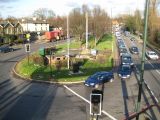
Robin Hood Roundabout, Kingston-upon-Thames / Nigel Cox, 30 jan. 2008, Creative Commons, via Geograph.
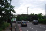
A3, Robin Hood Roundabout / N. Chadwick, 7 May 2011, Creative Commons, via Geograph.
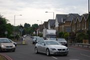
Robin Hood Roundabout / N. Chadwick, 7 May 2011, Creative Commons, via Geograph.
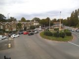
Robin Hood Roundabout / David Howard 28 Sep. 2014, Creative Commons, via Geograph.


