
Robin Hood Roundabout (Kingston-upon-Thames): Difference between revisions
From International Robin Hood Bibliography
m (→Maps) |
mNo edit summary |
||
| Line 3: | Line 3: | ||
[[File:{{#var:Pnimage}}|thumb|right|500px|Robin Hood Roundabout, Kingston-upon-Thames / [https://www.geograph.org.uk/photo/675837 Nigel Cox, 30 jan. 2008, Creative Commons via Geograph.]]] | [[File:{{#var:Pnimage}}|thumb|right|500px|Robin Hood Roundabout, Kingston-upon-Thames / [https://www.geograph.org.uk/photo/675837 Nigel Cox, 30 jan. 2008, Creative Commons via Geograph.]]] | ||
<p id="byline">By Henrik Thiil Nielsen, 2019-02-23. Revised by {{#realname:{{REVISIONUSER}}}}, {{REVISIONYEAR}}-{{REVISIONMONTH}}-{{REVISIONDAY2}}.</p><div class="no-img"> | <p id="byline">By Henrik Thiil Nielsen, 2019-02-23. Revised by {{#realname:{{REVISIONUSER}}}}, {{REVISIONYEAR}}-{{REVISIONMONTH}}-{{REVISIONDAY2}}.</p><div class="no-img"> | ||
<!--A3 Robin Hood Roundabout | |||
It's a roundabout, Jim, but not as we know it..., since you can't drive round it, at least not since 1995 can you have done. Actually this is now just the junction between the A3 and the A308 Kingston Vale. In the photo, which was taken from the footbridge, the southbound A3 is on the right, the queuing traffic is waiting to turn south westwards on the A308 to the lower left and the northbound A3 is on the upper left. The roundabout marks the start of the Kingston Bypass, opened in 1927. Formerly the A3 followed the current route of the A308 through Kingston upon Thames. | |||
Plans are afoot to improve access for equestrian users between Richmond Park to the left and the tracks to Wimbledon Common on the right. Apparently at present they have to rely on the courtesy of drivers on the A3 to let them pass...! The Robin Hood Gate entrance to Richmond Park is in front of the white house by the red truck trailer. | |||
For aficionados of such things a sewer vent pipe, grey with a yellow top, forms the centrepiece of the roundabout. It is surrounded by a motley collection of utilities' cabinets. --> | |||
<!-- | |||
The A3, known as the Portsmouth Road for much of its length, is a dual carriageway, or expressway, which follows the historic route between London and Portsmouth. For much of its 67 mile length, it is a trunk road and, apart from a section in London is dual carriageway. At its southerly end, the original road has been replaced by the A3(M), but the designation A3 is still used to identify the old road. The road goes through the newly constructed Hindhead Tunnel. | |||
--> | |||
{{PnItemQry}} | {{PnItemQry}} | ||
== Gazetteers == | == Gazetteers == | ||
| Line 29: | Line 38: | ||
<references/>--> | <references/>--> | ||
</div> | </div> | ||
{{ImgGalleryIntro}} | {{ImgGalleryIntro}} | ||
<gallery widths="195px"> | <gallery widths="195px"> | ||
File:robin-hood-roundabout-kingston-upon-thames.jpg|Robin Hood Roundabout, Kingston-upon-Thames / [https://www.geograph.org.uk/photo/675837 Nigel Cox, 30 jan. 2008, Creative Commons via Geograph.] | |||
</gallery | File:geograph-2575518-by-N-Chadwick.jpg|A3, Robin Hood Roundabout / [https://www.geograph.org.uk/photo/2575518 N. Chadwick, 7 May 2011, Creative Commons via Geograph.] | ||
File:geograph-2575532-by-N-Chadwick|Robin Hood Roundabout / [https://www.geograph.org.uk/photo/2575532 N. Chadwick, 7 May 2011, Creative Commons via Geograph.] | |||
</gallery> | |||
{{PnItemNav}} | {{PnItemNav}} | ||
Revision as of 22:20, 23 February 2019
Robin Hood Roundabout, Kingston-upon-Thames
[[File:|thumb|right|500px|Robin Hood Roundabout, Kingston-upon-Thames / Nigel Cox, 30 jan. 2008, Creative Commons via Geograph.]]
By Henrik Thiil Nielsen, 2019-02-23. Revised by Henrik Thiil Nielsen, 2019-02-23.
Gazetteers
- Not included in Dobson, R. B., ed.; Taylor, J., ed. Rymes of Robyn Hood: an Introduction to the English Outlaw (London, 1976), pp. 293-311.
Maps
- 6" O.S. map Middlesex XXI (1873; surveyed 1865-66)
- 6" O.S. map Surrey VII (1874; surveyed 1865)
- 6" O.S. map Surrey VII.SW (1899; rev. 1893-95) (georeferenced)
- 6" O.S. map Surrey VII.SW (1899; rev. 1893-95)
- 6" O.S. map Surrey VII.SW (1920; rev. 1911)
- 6" O.S. map Surrey VII.SW (c. 1933; rev. 1911)
- 6" O.S. map Surrey VII.SW (1936; rev. 1932-33)
- 6" O.S. map Surrey VII.SW (c. 1944; rev. 1938)
- 6" O.S. map Surrey VII.SW (c. 1946; rev. 1938).
- 6" O.S. map London X.SW (1894-96; rev. 1893-95)
- 25" O.S. map London (1869; surveyed 1865-67)
- 25" O.S. map Surrey VII.9 (1897; rev. 1894) (georeferenced)
- 25" O.S. map London (1915- Numbered sheets) VIII.14 (1916; rev. 1913) (georeferenced)
- 25" O.S. map London (1916; rev. 1913).
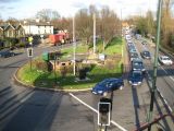
Robin Hood Roundabout, Kingston-upon-Thames / Nigel Cox, 30 jan. 2008, Creative Commons via Geograph.
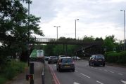
A3, Robin Hood Roundabout / N. Chadwick, 7 May 2011, Creative Commons via Geograph.
- Geograph-2575532-by-N-Chadwick
Robin Hood Roundabout / N. Chadwick, 7 May 2011, Creative Commons via Geograph.

