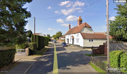
Robin Hood Road (Elsenham)
From International Robin Hood Bibliography
| Locality | |
|---|---|
| Coordinate | 51.912511, 0.229899 |
| Adm. div. | Essex |
| Vicinity | South side of Stansted Road, Elsenham, Bishops Stortford |
| Type | Thoroughfare |
| Interest | Robin Hood name |
| Status | Extant |
| First Record | |
Robin Hood Road (Elsenham).
By Henrik Thiil Nielsen, 2018-01-10. Revised by Henrik Thiil Nielsen, 2021-02-13.
Robin Hood Road in Elsenham, Bishops Stortford, runs roughly south from Stansted Road. No doubt it was named after the long defunct Robin Hood pub there.
Gazetteers
- Not included in Dobson, R. B., ed.; Taylor, J., ed. Rymes of Robyn Hood: an Introduction to the English Outlaw (London, 1976), pp. 293-311.
Maps
- 25" O.S. map Essex XXIII.1 (c. 1881; surveyed 1876). No copy in NLS
- 25" O.S. map Essex XXIII.1 (c. 1897; rev. c. 1896). No copy in NLS
- 25" O.S. map Essex nXXIII.12 (1920; rev. 1919) (georeferenced)
- 25" O.S. map Essex (1920; rev. 1919)
- 6" O.S. map Essex XXIII (1881; surveyed 1875–76)
- 6" O.S. map Hertfordshire XV (1881–83; surveyed 1875)
- 6" O.S. map Essex XXIII.NW (1898; rev. 1896) (georeferenced)
- 6" O.S. map Essex XXIII.NW (1898; rev. 1896)
- 6" O.S. map Essex nXXIII (1923; rev. 1916–19)
- 6" O.S. map Essex nXXIII (1951; rev. 1946–47).
Also see

