
Robin Hood Lane (Hall Green)
From International Robin Hood Bibliography
| Locality | |
|---|---|
| Coordinate | 52.426535, -1.850741 |
| Adm. div. | Worcestershire |
| Vicinity | Between Cole Valley Road/Sarehold Road and Stratford Road |
| Type | Thoroughfare |
| Interest | Robin Hood name |
| Status | Extant |
| First Record | |
Robin Hood Lane (Hall Green).

By Henrik Thiil Nielsen, 2018-01-12. Revised by Henrik Thiil Nielsen, 2021-01-07.
Robin Hood Lane is a major street in Hall Green, connecting Cole Valley Road/Sarehold Road and Stratford Road.
Gazetteers
- Not included in Dobson, R. B., ed.; Taylor, J., ed. Rymes of Robyn Hood: an Introduction to the English Outlaw (London, 1976), pp. 293-311.
Also see
Image gallery
Click any image to display it in the lightbox, where you can navigate between images by clicking in the right or left side of the current image.
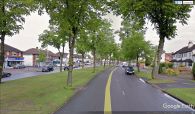
Robin Hood Lane, Hall Green / Google Earth Street View.
