
Robin Hood Lane (Appley Bridge)
| Locality | |
|---|---|
| Coordinate | 53.596233, -2.727709 |
| Adm. div. | Lancashire |
| Vicinity | Between Hill House Fold Lane and Sparrow Hill/Hall Lane (A5209) |
| Type | Thoroughfare |
| Interest | Robin Hood name |
| Status | Extant |
| First Record | 1894 |

By Henrik Thiil Nielsen, 2018-01-10. Revised by Henrik Thiil Nielsen, 2021-01-07.
Robin Hood Lane just north of Appley Bridge runs between Hill House Fold Lane and Sparrow Hill/Hall Lane (A5209).
The earliest records of the name known to IRHB are the 6" and 25" O.S. maps published in 1894, based on surveys carried out in 1892-93, respectively 1892 (see Maps below).
Gazetteers
- Not included in Dobson, R. B., ed.; Taylor, J., ed. Rymes of Robyn Hood: an Introduction to the English Outlaw (London, 1976), pp. 293-311.
Maps
- 25" O.S. map Lancashire LXXXV.5 (1908; rev. 1907) (georeferenced)
- 25" O.S. map Lancashire LXXXV.9 (1908; rev. 1907) (georeferenced)
- 25" O.S. map Lancashire LXXXV.5 (1894; surveyed 1892)
- 25" O.S. map Lancashire LXXXV.9 (1894; surveyed 1892)
- 25" O.S. map Lancashire LXXXV.5 (1908; rev. 1907)
- 25" O.S. map Lancashire LXXXV.9 (1908; rev. 1907)
- 25" O.S. map Lancashire LXXXV.9 (1928; rev. 1926)
- 25" O.S. map Lancashire LXXXV.5 (1928; rev. 1927)
- 6" O.S. map Lancashire LXXXV (1849; surveyed 1845-46)
- 6" O.S. map Lancashire LXXXV.NW (1894; surveyed 1892-93)
- 6" O.S. map Lancashire LXXXV.SW (1895; surveyed 1892)
- 6" O.S. map Lancashire LXXXV.NW (1909; rev. 1907) (georeferenced)
- 6" O.S. map Lancashire LXXXV.NW (1909; rev. 1907)
- 6" O.S. map Lancashire LXXXV.SW (1909; rev. 1907)
- 6" O.S. map Lancashire LXXXV.NW (1929; rev. 1927)
- 6" O.S. map Lancashire LXXXV.SW (1929; rev. 1926)
- 6" O.S. map Lancashire LXXXV.NW (1947; rev. 1938)
- 6" O.S. map Lancashire LXXXV.SW (1947; rev. 1938)
- 6" O.S. map Lancashire LXXXV.SW (1951; rev. 1938-48).
Also see
Image gallery
Click any image to display it in the lightbox, where you can navigate between images by clicking in the right or left side of the current image.
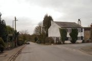
Robin Hood: The junction of Robin Hood Lane with High Moor Lane / David Dixon, 22 Feb. 2016, Creative Commons, via Geograph.
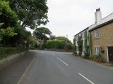
Robin Hood: The end of High Moor Lane / Richard Webb, 2 Jul. 2014, Creative Commons, via Geograph.
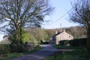
Junction of Moss Lane and Robin Hood Lane seen from Hill House Fold Lane / Chris Denny, 26 Apr. 2010, Creative Commons, via Geograph.
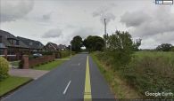
Robin Hood Lane / Google Earth Street View.


