Robin Hood Junction (Robin Hood, Wakefield): Difference between revisions
From International Robin Hood Bibliography
mNo edit summary |
mNo edit summary |
||
| Line 4: | Line 4: | ||
<p id="byline">By Henrik Thiil Nielsen, 2016-12-31. Revised by {{#realname:{{REVISIONUSER}}}}, {{REVISIONYEAR}}-{{REVISIONMONTH}}-{{REVISIONDAY2}}.</p> | <p id="byline">By Henrik Thiil Nielsen, 2016-12-31. Revised by {{#realname:{{REVISIONUSER}}}}, {{REVISIONYEAR}}-{{REVISIONMONTH}}-{{REVISIONDAY2}}.</p> | ||
<div class="no-img"> | <div class="no-img"> | ||
Robin Hood Junction in the village of Robin Hood, Wakefield, on the East and West Yorkshire Union Railway, is first recorded, as far as I know, on the 6" O.S. map of the area published in 1908. The railway was established in 1891 and extended a few years later. It closed in 1966.<ref>[http://www.lner.info/co/EWYUR/history.php The London & North Eastern Railway Encyclopedia: Brief History of the EWYUR.]</ref> As seen in the photo below the | Robin Hood Junction in the village of Robin Hood, Wakefield, on the East and West Yorkshire Union Railway, is first recorded, as far as I know, on the 6" O.S. map of the area published in 1908. The railway was established in 1891 and extended a few years later. It closed in 1966.<ref>[http://www.lner.info/co/EWYUR/history.php The London & North Eastern Railway Encyclopedia: Brief History of the EWYUR.]</ref> As seen in the photo below, the tracks have now been replaced by a nice footpath. | ||
{{PnItemQry}} | {{PnItemQry}} | ||
== Gazetteers == | == Gazetteers == | ||
Revision as of 11:28, 8 June 2019
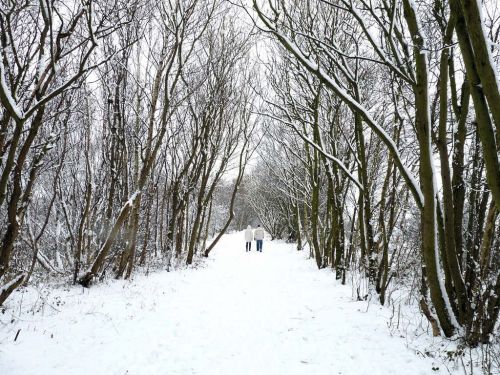
Approximate site of Robin Hood Junction.
By Henrik Thiil Nielsen, 2016-12-31. Revised by Henrik Thiil Nielsen, 2019-06-08.
Robin Hood Junction in the village of Robin Hood, Wakefield, on the East and West Yorkshire Union Railway, is first recorded, as far as I know, on the 6" O.S. map of the area published in 1908. The railway was established in 1891 and extended a few years later. It closed in 1966.[1] As seen in the photo below, the tracks have now been replaced by a nice footpath. Template:PnItemQry
Gazetteers
- Not included in Dobson, R. B., ed.; Taylor, J., ed. Rymes of Robyn Hood: an Introduction to the English Outlaw (London, 1976), pp. 293-311.
Maps
- 6" O.S. map Yorkshire 233 (1854; rev. 1848-51)
- 6" O.S. map Yorkshire CCXXXIII.NE (1894; rev. 1892)
- 6" O.S. map Yorkshire CCXXXIII.NE 1908; rev. 1905)
- 6" O.S. map Yorkshire CCXXXIII.NE (1908; rev. 1905) (georeferenced)
- 6" O.S. map Yorkshire CCXXXIII.NE (1931; rev. 1931-32) [Sic]
- 6" O.S. map Yorkshire CCXXXIII.NE (1947; rev. 1938)
- 6" O.S. map Yorkshire CCXXXIII.NE (1949; rev. 1948).

