Robin Hood Junction (Robin Hood, Wakefield): Difference between revisions
From International Robin Hood Bibliography
m (Text replacement - " === Notes ===" to " === Notes ===") |
m (Text replacement - "Category:Place-Names-topics" to "Category:Place-names-topics") |
||
| Line 48: | Line 48: | ||
{{#ask: [[Category:English place-names]][[Utitle::<<{{#replace:{{uc:{{PAGENAME}}}}|'|'}}]]|order=descending|searchlabel=|format=template|introtemplate=BeforeNav|template=Nav|outrotemplate=Previous|link=none|limit=1|sort=Utitle}}[[Place-names]]{{#ask: [[Category:English place-names]][[Utitle::>>{{#replace:{{uc:{{PAGENAME}}}}|'|'}}]]|order=ascending|searchlabel=|format=template|introtemplate=BeforeNav|template=Nav|outrotemplate=Next|link=none|limit=1|sort=Utitle}}</div></div> | {{#ask: [[Category:English place-names]][[Utitle::<<{{#replace:{{uc:{{PAGENAME}}}}|'|'}}]]|order=descending|searchlabel=|format=template|introtemplate=BeforeNav|template=Nav|outrotemplate=Previous|link=none|limit=1|sort=Utitle}}[[Place-names]]{{#ask: [[Category:English place-names]][[Utitle::>>{{#replace:{{uc:{{PAGENAME}}}}|'|'}}]]|order=ascending|searchlabel=|format=template|introtemplate=BeforeNav|template=Nav|outrotemplate=Next|link=none|limit=1|sort=Utitle}}</div></div> | ||
[[Category:West Riding of Yorkshire place-names]] | [[Category:West Riding of Yorkshire place-names]] | ||
[[Category:Place- | [[Category:Place-names-topics]] | ||
[[Category:Robin Hood place-name cluster]] | [[Category:Robin Hood place-name cluster]] | ||
[[Category:Wakefield place-name cluster]] | [[Category:Wakefield place-name cluster]] | ||
Revision as of 17:37, 2 June 2017
| Locality | |
|---|---|
| Coordinates | 53.7428, -1.5038 |
| Adm. div. | West Riding of Yorkshire |
| Vicinity | Leeds Road, Wakefield |
| Type | Transport |
| Interest | Robin Hood name |
| Status | Extant |
| First Record | 1908 |
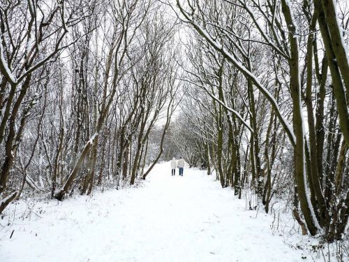
Approximate site of Robin Hood Junction.
By Henrik Thiil Nielsen, 2016-12-31. Revised by Henrik Thiil Nielsen, 2017-06-02.
Robin Hood Junction in the village of Robin Hood, Wakefield, on the East and West Yorkshire Union Railway, is first recorded, as far as I know, on the 6" O.S. map of the area published in 1908. The railway was established in 1891 and extended a few years later. It closed in 1966.[1] As seen in the photo below the tarcks have now been replaced by a nice footpath.
Maps
- 6" O.S. map Yorkshire 233 (1854; rev. 1848-51)
- 6" O.S. map Yorkshire CCXXXIII.NE (1894; rev. 1892)
- 6" O.S. map Yorkshire CCXXXIII.NE 1908; rev. 1905)
- 6" O.S. map Yorkshire CCXXXIII.NE (1908; rev. 1905) (georeferenced)
- 6" O.S. map Yorkshire CCXXXIII.NE (1931; rev. 1931-32) [Sic]
- 6" O.S. map Yorkshire CCXXXIII.NE (1947; rev. 1938)
- 6" O.S. map Yorkshire CCXXXIII.NE (1949; rev. 1948).
Background
Also see
Notes
Template:BeforeNavTemplate:NavTemplate:PreviousWest Riding of Yorkshire place-namesTemplate:BeforeNavTemplate:NavTemplate:Next
Template:BeforeNavTemplate:NavTemplate:PreviousYorkshire place-namesTemplate:BeforeNavTemplate:NavTemplate:Next
Template:BeforeNavTemplate:NavTemplate:PreviousPlace-namesTemplate:BeforeNavTemplate:NavTemplate:Next"?" is not a number.

