
Robin Hood Inn (Rainworth)
| Locality | |
|---|---|
| Coordinate | 53.118975, -1.11839 |
| Adm. div. | Nottinghamshire |
| Vicinity | Intersection of Southwell Road East and Kirklington Road |
| Type | Public house |
| Interest | Robin Hood name |
| Status | Defunct |
| First Record | 1884 |

By Henrik Thiil Nielsen, 2018-05-22. Revised by Henrik Thiil Nielsen, 2021-01-07.
Robin Hood Inn in Rainworth was located at the intersection of Southwell Road East and Kirklington Road. Included on a 6" O.S. map of the area dated 1884, it appears under that name as late as 1946. A map dated 1947 labels the building 'Hotel'. However, the first photo in the image gallery below, taken 2008, shows that it still functioned as a pub at that time. The building now houses a Tesco Express. UK Pub History lists information on publicans for the years 1925-41.[1]
Gazetteers
- Not included in Dobson, R. B., ed.; Taylor, J., ed. Rymes of Robyn Hood: an Introduction to the English Outlaw (London, 1976), pp. 293-311.
Sources
Maps
- 25" O.S. map Nottinghamshire XXVIII.7 (1885; surveyed 1884)
- 25" O.S. map Nottinghamshire XXVIII.7 (1900; rev. 1897)
- 25" O.S. map Nottinghamshire XXVIII.7 (1900; rev. 1897) (georeferenced)
- 25" O.S. map Nottinghamshire XXVIII.7 (1915; rev. 1913)
- 25" O.S. map Nottinghamshire XXVIII.7 (1946; rev. 1939)
- 6" O.S. map Nottinghamshire XXVIII.NE (1884; surveyed 1877-84)
- 6" O.S. map Nottinghamshire XXVIII.NE (1900; rev. 1897)
- 6" O.S. map Nottinghamshire XXVIII.NE (1900; rev. 1897) (georeferenced)
- 6" O.S. map Nottinghamshire XXVIII.NE (1920; rev. 1913)
- 6" O.S. map Nottinghamshire XXVIII.NE (1947; rev. 1938).
Also see
Notes
Image gallery
Click any image to display it in the lightbox, where you can navigate between images by clicking in the right or left side of the current image.
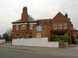
The Robin Hood public house, Rainworth / Steve Fareham, 12 Sep. 2008, Creative Commons, via Geograph.

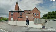
Tesco Express, Rainworth: formerly the Robin Hood pub / J. Thomas, 17 mar. 2014, Creative Commons, via Geograph.
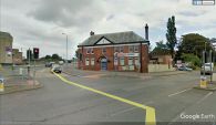
The Robin Hood Inn, Rainworth, seen from the intersection of Southwell Road East and Kirklington Road / Google Earth Street View.
The Robin Hood Inn, Rainworth, seen from Southwell Road East / Google Earth Street View.
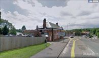
The Robin Hood Inn, Rainworth, seen from Kirklington Road / Google Earth Street View.


