
Robin Hood Inn (Rainworth)
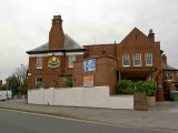
[[File:|thumb|right|500px|The Robin Hood Inn, Rainworth, seen from the intersection of Southwell Road East and Kirklington Road / Google Earth Street View.]]
By Henrik Thiil Nielsen, 2018-05-22. Revised by Henrik Thiil Nielsen, 2018-10-24.
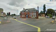
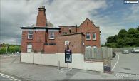
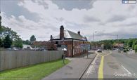
Robin Hood Inn in Rainworth was located at the intersection of Southwell Road East and Kirklington Road. Included on a 6" O.S. map of the area dated 1884, it appears under that name as late as 1946. A map dated 1947 labels the building 'Hotel'. However, the first photo in the image gallery below, taken 2008, shows that it still functioned as a pub at that time. The building now houses a Tesco Express. UK Pub History lists information on publicans for the years 1925-41.[1]Template:PnItemQry
Gazetteers
- Not included in Dobson, R. B., ed.; Taylor, J., ed. Rymes of Robyn Hood: an Introduction to the English Outlaw (London, 1976), pp. 293-311.
Sources
Maps
- 25" O.S. map Nottinghamshire XXVIII.7 (1885; surveyed 1884)
- 25" O.S. map Nottinghamshire XXVIII.7 (1900; rev. 1897)
- 25" O.S. map Nottinghamshire XXVIII.7 (1900; rev. 1897) (georeferenced)]
- 25" O.S. map Nottinghamshire XXVIII.7 (1915; rev. 1913)
- 25" O.S. map Nottinghamshire XXVIII.7 (1946; rev. 1939)
- 6" O.S. map Nottinghamshire XXVIII.NE (1884; surveyed 1877-84)
- 6" O.S. map Nottinghamshire XXVIII.NE (1900; rev. 1897)
- 6" O.S. map Nottinghamshire XXVIII.NE (1900; rev. 1897) (georeferenced)
- 6" O.S. map Nottinghamshire XXVIII.NE (1920; rev. 1913)
- 6" O.S. map Nottinghamshire XXVIII.NE (1947; rev. 1938).
Notes
The Robin Hood public house, Rainworth / Steve Fareham, 12 Sep. 2008, Creative Commons via Geograph.

Tesco Express, Rainworth: formerly the Robin Hood pub / J. Thomas, 17 mar. 2014, Creative Commons via Geograph.
The Robin Hood Inn, Rainworth, seen from the intersection of Southwell Road East and Kirklington Road / Google Earth Street View.
The Robin Hood Inn, Rainworth, seen from Southwell Road East / Google Earth Street View.
The Robin Hood Inn, Rainworth, seen from Kirklington Road / Google Earth Street View.


