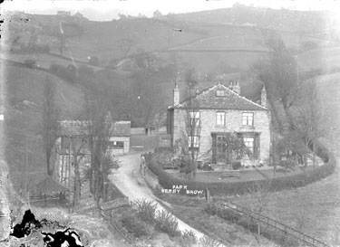
Robin Hood House (Berry Brow)
From International Robin Hood Bibliography
Approximate location of Robin Hood House.

Robin Hood House / Kirklees Image Archive.
By Henrik Thiil Nielsen, 2013-08-04. Revised by Henrik Thiil Nielsen, 2017-12-18.
The English Place-Name Society volume that covers the Huddersfield area lists Robin Hood Hill and Robin Hood House (under Almondbury parish)[1] without any source reference, which usually indicates a modern date. Robin Hood Hill is the name of a c. 200 m long section of a lane off Woodhead Road. A short, roughly L-shaped side road is named Hood Street. Robin Hood House is located on Hood Street. There are now only two houses on Hood Street; of these the one indicated on the Google map looks most like the house on the old photograph.
Notes
Gazetteers
Sources
- Adkin, Valerie. 'An Unexpected Discovery', Huddersfield Local History Society Journal, No. 18 (2006-2007), pp. ?-?. Not seen.
- Smith, A.H. The Place-Names of the West Riding of Yorkshire (English Place-Name Society, vols. XXX-XXXVII) (Cambridge, 1961-63), pt. II, p. 261.
Also see
