
Robin Hood Hotel (Kingston-upon-Thames): Difference between revisions
From International Robin Hood Bibliography
mNo edit summary |
mNo edit summary |
||
| Line 21: | Line 21: | ||
{{PnItemAlsoSee}} | {{PnItemAlsoSee}} | ||
</div> | </div> | ||
{{ImgGalleryIntro}} | {{ImgGalleryIntro}} | ||
<gallery widths="195px"> | <gallery widths="195px"> | ||
Stengel and Co 1908a-r.jpg|{{:Stengel and Co 1908a}} / Private collection. | File:Stengel and Co 1908a-r.jpg|{{:Stengel and Co 1908a}} / Private collection. | ||
robin-hood-hotel-kingston-vale-google-earth-street-view.jpg|Site of Robin Hood Hotel / Google Earth Street View. | File:Anonymous 1912c-r.jpg|{{:Anonymous 1912c}} / Private collection. | ||
File:robin-hood-hotel-kingston-vale-google-earth-street-view.jpg|Site of Robin Hood Hotel / Google Earth Street View. | |||
</gallery> | </gallery> | ||
{{PnItemNav}} | {{PnItemNav}} | ||
Revision as of 23:25, 11 October 2018
Robin Hood Hotel (Kingston-upon-Thames).
By Henrik Thiil Nielsen, 2018-01-13. Revised by Henrik Thiil Nielsen, 2018-10-11.
The Robin Hood Hotel a.k.a. the Robin Hood Inn was located on the corner of Robin Hood Lane and Kingston Vale (A308). The earliest reference I have is a 6" O.S. map of the area published in 1874 (see Maps section below).Template:PnItemQry
Gazetteers
- Not included in Dobson, R. B., ed.; Taylor, J., ed. Rymes of Robyn Hood: an Introduction to the English Outlaw (London, 1976), pp. 293-311.
Maps
- 6" O.S. map Surrey VII (1874; surveyed 1865)
- 6" O.S. map Surrey VII.SW (1899; rev. 1893-95) (georeferenced)
- 6" O.S. map Surrey VII.SW (1899; rev. 1893-95)
- 6" O.S. map Surrey VII.SW (1920; rev. 1911)
- 6" O.S. map Surrey VII.SW (c. 1933; rev. 1911)
- 6" O.S. map Surrey VII.SW (1936; rev. 1932-33)
- 6" O.S. map Surrey VII.SW (c. 1944; rev. 1938)
- 6" O.S. map Surrey VII.SW (c. 1946; rev. 1938).
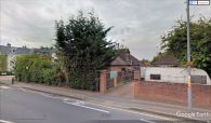
Site of Robin Hood Hotel / Google Earth Street View.


