
Robin Hood Hotel (Chorley): Difference between revisions
m (Text replacement - "|service=leaflet}}" to "|service=leaflet|enablefullscreen=yes}}") |
m (→Maps) |
||
| Line 13: | Line 13: | ||
* [http://chorleyinnsandtaverns.blogspot.com/p/robin-hood-hotel.html Chorley's Inns and Taverns: Robin Hood Hotel] by Richard Langford. | * [http://chorleyinnsandtaverns.blogspot.com/p/robin-hood-hotel.html Chorley's Inns and Taverns: Robin Hood Hotel] by Richard Langford. | ||
== Maps == | == Maps == | ||
* [https://maps.nls.uk/view/126519146#zoom=5&lat=1287&lon=3835&layers=BT 25" O.S. map ''Lancashire'' LXXVII.8 (1894; surveyed 1889-93)] | |||
* [https://maps.nls.uk/geo/explore/#zoom=17&lat=53.6564&lon=-2.6294&layers=168&b=5 25" O.S. map ''Lancashire'' LXXVII.8 (1910; rev. 1909)] (georeferenced) | |||
* [https://maps.nls.uk/view/126519149#zoom=5&lat=1416&lon=4134&layers=BT 25" O.S. map ''Lancashire'' LXXVII.8 (1910; rev. 1909)] | |||
* [https://maps.nls.uk/view/126519152#zoom=5&lat=1159&lon=3413&layers=BT 25" O.S. map ''Lancashire'' LXXVII.8 (1928; rev. 1927)] | |||
* [https://maps.nls.uk/view/126519155#zoom=5&lat=1161&lon=3639&layers=BT 25" O.S. map ''Lancashire'' LXXVII.8 (1940; rev. 1938)] | |||
* [https://maps.nls.uk/view/102343994#zoom=6&lat=5352&lon=11708&layers=BT 6" O.S. map ''Lancashire'' LXXVII (1849; surveyed 1844-47)] | * [https://maps.nls.uk/view/102343994#zoom=6&lat=5352&lon=11708&layers=BT 6" O.S. map ''Lancashire'' LXXVII (1849; surveyed 1844-47)] | ||
* [https://maps.nls.uk/view/101102450#zoom=4&lat=1466&lon=5080&layers=BT 6" O.S. map ''Lancashire'' LXXVII.NE (1895; surveyed 1888-93)] | * [https://maps.nls.uk/view/101102450#zoom=4&lat=1466&lon=5080&layers=BT 6" O.S. map ''Lancashire'' LXXVII.NE (1895; surveyed 1888-93)] | ||
| Line 18: | Line 23: | ||
* [https://maps.nls.uk/view/101102447#zoom=5&lat=1557&lon=5242&layers=BT 6" O.S. map ''Lancashire'' LXXVII.NE (1912; rev. 1909)] | * [https://maps.nls.uk/view/101102447#zoom=5&lat=1557&lon=5242&layers=BT 6" O.S. map ''Lancashire'' LXXVII.NE (1912; rev. 1909)] | ||
* [https://maps.nls.uk/view/101102444#zoom=5&lat=1461&lon=5202&layers=BT 6" O.S. map ''Lancashire'' LXXVII.NE (1930; rev. 1927)] | * [https://maps.nls.uk/view/101102444#zoom=5&lat=1461&lon=5202&layers=BT 6" O.S. map ''Lancashire'' LXXVII.NE (1930; rev. 1927)] | ||
* [https://maps.nls.uk/view/101102441#zoom=5&lat=1454&lon=5184&layers=BT 6" O.S. map ''Lancashire'' LXXVII.NE (1947 | * [https://maps.nls.uk/view/101102441#zoom=5&lat=1454&lon=5184&layers=BT 6" O.S. map ''Lancashire'' LXXVII.NE (1947; rev. 1938).] | ||
<!--== Discussion == | <!--== Discussion == | ||
| Line 32: | Line 32: | ||
* --> | * --> | ||
{{PnItemAlsoSee}} | {{PnItemAlsoSee}} | ||
== Notes == | == Notes == | ||
<references/> | <references/> | ||
Revision as of 12:33, 31 May 2019
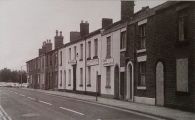
[[File:|thumb|right|500px|The Robin Hood Hotel / Chorley's Inns and Taverns: Robin Hood Hotel, by Richard Langford]]
By Henrik Thiil Nielsen, 2019-02-22. Revised by Henrik Thiil Nielsen, 2019-05-31.
The Robin Hood Hotel at 126 Clifford Street in Chorley existed under that name by 1875. It closed and its premises were demolished c. 1989.
The Robin Hood Hotel is said to date back to the 1860's when Clifford Street was developed. However, the first notice with a certain date is in a newspaper article from 23 Aug. 1876.[1] At the rear of the hotel was an added attraction in the form a large bowling green. The premises of the pub were among the buildings demolished to make way for the south-bound carriageway of the Chorley By-pass (A6) c. 1989. Topps Tiles (see photo in image gallery below) now occupies the area that was once the pub's bowling green.[2] Template:PnItemQry
Gazetteers
- Not included in Dobson, R. B., ed.; Taylor, J., ed. Rymes of Robyn Hood: an Introduction to the English Outlaw (London, 1976), pp. 293-311.
Sources
- Chorley's Inns and Taverns: Robin Hood Hotel by Richard Langford.
Maps
- 25" O.S. map Lancashire LXXVII.8 (1894; surveyed 1889-93)
- 25" O.S. map Lancashire LXXVII.8 (1910; rev. 1909) (georeferenced)
- 25" O.S. map Lancashire LXXVII.8 (1910; rev. 1909)
- 25" O.S. map Lancashire LXXVII.8 (1928; rev. 1927)
- 25" O.S. map Lancashire LXXVII.8 (1940; rev. 1938)
- 6" O.S. map Lancashire LXXVII (1849; surveyed 1844-47)
- 6" O.S. map Lancashire LXXVII.NE (1895; surveyed 1888-93)
- 6" O.S. map Lancashire LXXVII.NE (1912; rev. 1909) (georeferenced)
- 6" O.S. map Lancashire LXXVII.NE (1912; rev. 1909)
- 6" O.S. map Lancashire LXXVII.NE (1930; rev. 1927)
- 6" O.S. map Lancashire LXXVII.NE (1947; rev. 1938).
Notes
The Robin Hood Hotel / Chorley's Inns and Taverns: Robin Hood Hotel, by Richard Langford

Bowling green behind the pub / Chorley's Inns and Taverns: Robin Hood Hotel, by Richard Langford

Topps Tiles now occupy the former bowling green / Google Earth Street View.

.jpg)
