Robin Hood Hill (Oxton): Difference between revisions
m (Text replacement - " <p id="byline">" to "<div class="no-img"><p id="byline">") |
m (Text replacement - ".</p><div class="no-img">" to ".</p>") |
||
| Line 1: | Line 1: | ||
__NOTOC__{{PnItemTop|Lat=53.0750|Lon=-1.0562|AdmDiv=Nottinghamshire|Vicinity=1.9 km NNE of central Oxton|Type=Prehistoric site|Interest=Robin Hood name|Status=Extant|Demonym=|Riding=|GreaterLondon=|Year=1884|Aka=|Century=|Cluster1=Oxton|Cluster2=|Cluster3=|Image=robin_hood_hill_oxton_martin_jones.jpg|Postcards=|ExtraCat1=Places named Robin Hood's Hill|ExtraCat2=|ExtraCat3=|ExtraCat4=|ExtraCat5=|ExtraLink1=|ExtraLink2=|ExtraLink3=|ExtraLink4=|ExtraLink5=|ExtraLinkName1=|ExtraLinkName2=|ExtraLinkName3=|ExtraLinkName4=|ExtraLinkName5=|GeopointPrefix=|GeopointSuffix=|StatusSuffix=|DatePrefix=|DateSuffix=}} | __NOTOC__{{PnItemTop|Lat=53.0750|Lon=-1.0562|AdmDiv=Nottinghamshire|Vicinity=1.9 km NNE of central Oxton|Type=Prehistoric site|Interest=Robin Hood name|Status=Extant|Demonym=|Riding=|GreaterLondon=|Year=1884|Aka=|Century=|Cluster1=Oxton|Cluster2=|Cluster3=|Image=robin_hood_hill_oxton_martin_jones.jpg|Postcards=|ExtraCat1=Places named Robin Hood's Hill|ExtraCat2=|ExtraCat3=|ExtraCat4=|ExtraCat5=|ExtraLink1=|ExtraLink2=|ExtraLink3=|ExtraLink4=|ExtraLink5=|ExtraLinkName1=|ExtraLinkName2=|ExtraLinkName3=|ExtraLinkName4=|ExtraLinkName5=|GeopointPrefix=|GeopointSuffix=|StatusSuffix=|DatePrefix=|DateSuffix=}} | ||
{{#display_map:{{#var:Coords}}~{{#replace:{{PAGENAME}}|'|'}}|width=34%|service=leaflet|enablefullscreen=yes}}<div class="pnMapLegend">Robin Hood Hill.</div> | {{#display_map:{{#var:Coords}}~{{#replace:{{PAGENAME}}|'|'}}|width=34%|service=leaflet|enablefullscreen=yes}}<div class="pnMapLegend">Robin Hood Hill.</div> | ||
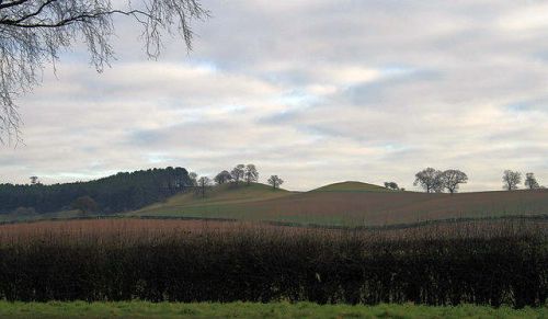
[[File:robin_hood_hill_oxton_martin_jones.jpg|thumb|right|500px|Robin Hood Hill with Loath Hill, believed to have been a Roman fortification, immediately to the north / © [http://www.geograph.org.uk/photo/1104196 Martin Jones, Creative Commons, via Geograph.]]]<div class="no-img"><p id="byline">By Henrik Thiil Nielsen, 2016-10-09. Revised by {{#realname:{{REVISIONUSER}}}}, {{REVISIONYEAR}}-{{REVISIONMONTH}}-{{REVISIONDAY2}}.</p | [[File:robin_hood_hill_oxton_martin_jones.jpg|thumb|right|500px|Robin Hood Hill with Loath Hill, believed to have been a Roman fortification, immediately to the north / © [http://www.geograph.org.uk/photo/1104196 Martin Jones, Creative Commons, via Geograph.]]]<div class="no-img"><p id="byline">By Henrik Thiil Nielsen, 2016-10-09. Revised by {{#realname:{{REVISIONUSER}}}}, {{REVISIONYEAR}}-{{REVISIONMONTH}}-{{REVISIONDAY2}}.</p> | ||
Gover, Mawer and Stenton in the English Place-Name Society's volume on Nottinghamshire do not provide any reference or first date for this place-name; instead they refer to the place-name [[Robin Hood Pit (Oxton)|Robin Hood Pit]], which is first mentioned in an O.S: map published ''c.'' 1825.<ref>{{:Gover, John Eric Bruce 1940a}}, pp. 173, 294.</ref> Robin Hood Hill is a tumulus, and the noun 'pit' can mean 'grave', but I find it unlikely that pit' should have been used for 'mound' as in their primary significations they are opposites. Perhaps the ''c.'' 1825 O.S. map was also their source for Robin Hood Hill, but until I have access to it, the 6" O.S. map of the area published in 1884 is the earliest source I have come across. Immediately north of Robin Hood Hill is Loath Hill, which according to Martin Jones, who took the photograph shown below, "is thought to have been a Roman fortification".<ref>[http://www.geograph.org.uk/photo/1104196 Grograph: SK6353: Robin Hood Hill].</ref> | Gover, Mawer and Stenton in the English Place-Name Society's volume on Nottinghamshire do not provide any reference or first date for this place-name; instead they refer to the place-name [[Robin Hood Pit (Oxton)|Robin Hood Pit]], which is first mentioned in an O.S: map published ''c.'' 1825.<ref>{{:Gover, John Eric Bruce 1940a}}, pp. 173, 294.</ref> Robin Hood Hill is a tumulus, and the noun 'pit' can mean 'grave', but I find it unlikely that pit' should have been used for 'mound' as in their primary significations they are opposites. Perhaps the ''c.'' 1825 O.S. map was also their source for Robin Hood Hill, but until I have access to it, the 6" O.S. map of the area published in 1884 is the earliest source I have come across. Immediately north of Robin Hood Hill is Loath Hill, which according to Martin Jones, who took the photograph shown below, "is thought to have been a Roman fortification".<ref>[http://www.geograph.org.uk/photo/1104196 Grograph: SK6353: Robin Hood Hill].</ref> | ||
{{PnItemQry}} | {{PnItemQry}} | ||
Revision as of 04:17, 17 May 2020

By Henrik Thiil Nielsen, 2016-10-09. Revised by Henrik Thiil Nielsen, 2020-05-17.
Gover, Mawer and Stenton in the English Place-Name Society's volume on Nottinghamshire do not provide any reference or first date for this place-name; instead they refer to the place-name Robin Hood Pit, which is first mentioned in an O.S: map published c. 1825.[1] Robin Hood Hill is a tumulus, and the noun 'pit' can mean 'grave', but I find it unlikely that pit' should have been used for 'mound' as in their primary significations they are opposites. Perhaps the c. 1825 O.S. map was also their source for Robin Hood Hill, but until I have access to it, the 6" O.S. map of the area published in 1884 is the earliest source I have come across. Immediately north of Robin Hood Hill is Loath Hill, which according to Martin Jones, who took the photograph shown below, "is thought to have been a Roman fortification".[2] Template:PnItemQry
Gazetteers
- Dobson, R. B., ed.; Taylor, J., ed. Rymes of Robyn Hood: an Introduction to the English Outlaw (London, 1976), p. 302, s.n. 'Robin Hood Hill'.
Sources
- Grograph: SK6353: Robin Hood Hill.
- Gover, J.E.B.; Mawer, Allen; Stenton, F.M. The Place-Names of Nottinghamshire (English Place-Name Society, vol. XVII) (Cambridge, 1940), pp. 173, 294.
Maps
- 6" O.S. map Nottinghamshire XXXIII.NE (1884; surveyed 1873-84)
- 6" O.S. map Nottinghamshire XXXIII.NE (1900; rev. 1898-99)
- 6" O.S. map Nottinghamshire XXXIII.NE (1920; rev. 1913).
Notes
