Robin Hood Green (Lostock Gralam)
From International Robin Hood Bibliography
The site of Robin Hood Green.

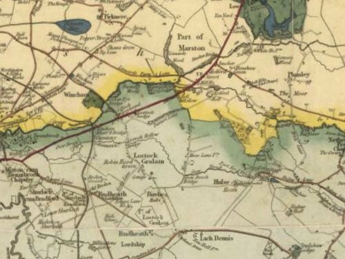
Andrew Bryant's Map of Cheshire, 1831. Robin Hood Green is indicated slightly southeast of centre / Cheshire Local History Association.
By Henrik Thiil Nielsen, 2017-01-17. Revised by Henrik Thiil Nielsen, 2019-04-05.
Located in Lostock Gralam, Robin Hood Green is first recorded on Andrew Bryant's 1831 Map of Cheshire.[1] Dodgson lists this place-name under 'Lostock Green', probably regarding it as another name for that hamlet,[2] but Bryant's map has it immediately west of Lostock Gralam, whereas Lostock Green is located c. 1 km south of Lostock Gralam. The two Greens can thus hardly be identical, unless Bryant's map has Robin Hood Green in the wrong place. The place-name would seem to be defunct, for as of January 2017 I have not found any mention of it on the Web.
Gazetteers
- Not included in Dobson, R. B., ed.; Taylor, J., ed. Rymes of Robyn Hood: an Introduction to the English Outlaw (London, 1976), pp. 293-311.
Sources
Maps
- Bryant, Andrew, Map of Cheshire (1831) (Cheshire Local History Association: 16th - 19th Century maps of Cheshire).
- 6" O.S. map Cheshire XXXIV (1882; surveyed 1874-77)
- 6" O.S. map Cheshire XXXIV.NE (1899; rev. 1897)
- 6" O.S. map Cheshire XXXIV.NE (1899; rev. 1897) (georeferenced)
- 6" O.S. map Cheshire XXXIV.NE (1911; rev. 1908)
- 6" O.S. map Cheshire XXXIV.NE (c. 1945; rev. 1938),
Background
Notes
- ↑ Bryant, A, Map of Cheshire (1831) (Cheshire Local History Association: 16th - 19th Century maps of Cheshire). According to Dodgson, John McN.; Rumble, Alexander R. The Place-Names of Cheshire, pts. I-V (English Place-Name Society, vols. XLIV-XLVIII, LIV, LXXIV) (Cambridge, 1970-72; [s.l.], 1981; Nottingham, 1997), vol. I, p. xxv, incorrectly cites Bryant's first name initial as W.
- ↑ Dodgson, op.cit., vol. II, p. 190,
