
Robin Hood Farm (Bassenthwaite): Difference between revisions
m (Text replacement - "{{#ask:[[Category:Records ({{#ifeq:{{#pos:{{PAGENAME}}|(|}}||{{PAGENAME}}|{{#sub:{{PAGENAME}}|0| {{#expr:{{#pos:{{PAGENAME}}|(|}}-1}} }},{{#sub:{{PAGENAME}}|{{#expr:{{#pos:{{PAGENAME}}|(|}}-1}}|1}}{{#sub:{{PAGENAME}}|{{#expr:{{#pos:...) |
m (Text replacement - "ImgGalleryIntro" to "ImageGalleryIntroduction") |
||
| (17 intermediate revisions by 2 users not shown) | |||
| Line 1: | Line 1: | ||
__NOTOC__{{ | __NOTOC__{{PlaceNamesItemTop|Lat=54.684790|Lon=-3.199017|AdministrativeDivision=Cumberland|Vicinity=''c.'' 550 m NNW of Bassenthwaite|Type=Building|Interest=Robin Hood name|Status=Extant|Demonym=|Riding=|GreaterLondon=|Year=|Aka=|Century=20|Cluster1=Bassenthwaite|Cluster2=|Cluster3=|Image=robin-hood-farm-bassenthwaite-google-earth-street-view.jpg|Postcards=|ExtraCat1=|ExtraCat2=|ExtraCat3=|ExtraCat4=|ExtraCat5=|ExtraLink1=|ExtraLink2=|ExtraLink3=|ExtraLink4=|ExtraLink5=|ExtraLinkName1=|ExtraLinkName2=|ExtraLinkName3=|ExtraLinkName4=|ExtraLinkName5=|GeopointPrefix=|GeopointSuffix=|StatusSuffix=|DatePrefix=|DateSuffix=}} | ||
{{#display_map:{{#var:Coords}}~{{#replace:{{PAGENAME}}|'|'}}|width=34%}}<div class="pnMapLegend">Robin Hood.</div> | {{#display_map:{{#var:Coords}}~{{#replace:{{PAGENAME}}|'|'}}|width=34%|enablefullscreen=yes}}<div class="pnMapLegend">Robin Hood.</div> | ||
[[File:robin-hood-farm-bassenthwaite-google-earth-street-view.jpg|thumb|right|500px|Robin Hood Farm / Google Earth Street View.]] | [[File:robin-hood-farm-bassenthwaite-google-earth-street-view.jpg|thumb|right|500px|Robin Hood Farm / Google Earth Street View.]]<div class="no-img"> | ||
<p id="byline">By Henrik Thiil Nielsen, 2017-08-30. Revised by {{#realname:{{REVISIONUSER}}}}, {{REVISIONYEAR}}-{{REVISIONMONTH}}-{{REVISIONDAY2}}.</p> | <p id="byline">By Henrik Thiil Nielsen, 2017-08-30. Revised by {{#realname:{{REVISIONUSER}}}}, {{REVISIONYEAR}}-{{REVISIONMONTH}}-{{REVISIONDAY2}}.</p> | ||
Robin Hood Farm is situated ''c.'' 2 km NE of Bassenthwaite Lake and ''c.'' 0.5 km NNW of Bassenthwaite village in an area labelled [[Robin Hood (Bassenthwaite)|'Robin Hood']] on the 6" O.S. map of the area published in 1867 as well as subsequent revisions (see Maps section below). The name 'Robin Hood' may have originated as a name for the area, the present [[Robin Hood Cottage (Bassenthwaite)|Robin Hood Cottage]] or, perhaps less likely, the farm. Not included on the O.S. maps, the name 'Robin Hood Farm' probably arose later, though hardly later than the 20th century, judging by the look of the sign next to the gate in the second photo in the Image Gallery below. | Robin Hood Farm is situated ''c.'' 2 km NE of Bassenthwaite Lake and ''c.'' 0.5 km NNW of Bassenthwaite village in an area labelled [[Robin Hood (Bassenthwaite)|'Robin Hood']] on the 6" O.S. map of the area published in 1867 as well as subsequent revisions (see Maps section below). The name 'Robin Hood' may have originated as a name for the area, the present [[Robin Hood Cottage (Bassenthwaite)|Robin Hood Cottage]] or, perhaps less likely, the farm. Not included on the O.S. maps, the name 'Robin Hood Farm' probably arose later, though hardly later than the 20th century, judging by the look of the sign next to the gate in the second photo in the Image Gallery below. | ||
About 225 m SSE of Robin Hood is found [[Robin Hood Wood (Bassenthwaite)|Robin Hood Wood]]. For other Robin Hood names in the vicinity, see [[Robin Hood (Bassenthwaite)]] and [[Bassenthwaite place-name cluster]]. | About 225 m SSE of Robin Hood is found [[Robin Hood Wood (Bassenthwaite)|Robin Hood Wood]]. For other Robin Hood names in the vicinity, see [[Robin Hood (Bassenthwaite)]] and [[Bassenthwaite place-name cluster]]. | ||
{{ | {{PlaceNamesItemAllusionsAndRecords}} | ||
== Gazetteers == | == Gazetteers == | ||
* Not included in {{:Dobson, Richard Barrie 1976a}}, pp. 293-311. | * Not included in {{:Dobson, Richard Barrie 1976a}}, pp. 293-311. | ||
| Line 18: | Line 17: | ||
* [http://maps.nls.uk/view/101091685#zoom=5&lat=2385&lon=7573&layers=BT 6" O.S. map ''Cumberland'' XLVI.SE (1900; rev. 1898)] | * [http://maps.nls.uk/view/101091685#zoom=5&lat=2385&lon=7573&layers=BT 6" O.S. map ''Cumberland'' XLVI.SE (1900; rev. 1898)] | ||
* [http://maps.nls.uk/geo/explore/#zoom=17&lat=54.6836&lon=-3.1997&layers=171&b=1 6" O.S. map ''Cumberland'' XLVI.SE (1900; rev. 1898)] (georeferenced) | * [http://maps.nls.uk/geo/explore/#zoom=17&lat=54.6836&lon=-3.1997&layers=171&b=1 6" O.S. map ''Cumberland'' XLVI.SE (1900; rev. 1898)] (georeferenced) | ||
* [http://maps.nls.uk/view/101091682#zoom=5&lat=2692&lon=7574&layers=BT 6" O.S. map ''Cumberland'' XLVI.SE (19230; rev. 1926)] | * [http://maps.nls.uk/view/101091682#zoom=5&lat=2692&lon=7574&layers=BT 6" O.S. map ''Cumberland'' XLVI.SE (19230; rev. 1926).] | ||
== Background == | == Background == | ||
* [https://en.wikipedia.org/wiki/Bassenthwaite Wikipedia: Bassenthwaite.] | * [https://en.wikipedia.org/wiki/Bassenthwaite Wikipedia: Bassenthwaite.] | ||
{{ | {{PlaceNamesItemAlsoSee}}<!-- | ||
== Notes == | == Notes == | ||
<references/>--> | <references/>--> | ||
</div> | </div> | ||
{{ | <div id="gallery"> | ||
{{ImageGalleryIntroduction}} | |||
<gallery widths="195px"> | <gallery widths="195px"> | ||
File:robin-hood-farm-bassenthwaite-google-earth-street-view.jpg|Robin Hood Farm / Google Earth Street View. | File:robin-hood-farm-bassenthwaite-google-earth-street-view.jpg|Robin Hood Farm / Google Earth Street View. | ||
File:robin-hood-farm-2-bassenthwaite-google-earth-street-view.jpg|Robin Hood Farm. Name on sign by the gate / Google Earth Street View. | File:robin-hood-farm-2-bassenthwaite-google-earth-street-view.jpg|Robin Hood Farm. Name on sign by the gate / Google Earth Street View. | ||
</gallery> | </gallery> | ||
</div> | |||
{{PlaceNamesItemNavigation}} | |||
{{ | |||
Latest revision as of 13:53, 7 January 2021
| Locality | |
|---|---|
| Coordinate | 54.68479, -3.199017 |
| Adm. div. | Cumberland |
| Vicinity | c. 550 m NNW of Bassenthwaite |
| Type | Building |
| Interest | Robin Hood name |
| Status | Extant |
| First Record | |

By Henrik Thiil Nielsen, 2017-08-30. Revised by Henrik Thiil Nielsen, 2021-01-07.
Robin Hood Farm is situated c. 2 km NE of Bassenthwaite Lake and c. 0.5 km NNW of Bassenthwaite village in an area labelled 'Robin Hood' on the 6" O.S. map of the area published in 1867 as well as subsequent revisions (see Maps section below). The name 'Robin Hood' may have originated as a name for the area, the present Robin Hood Cottage or, perhaps less likely, the farm. Not included on the O.S. maps, the name 'Robin Hood Farm' probably arose later, though hardly later than the 20th century, judging by the look of the sign next to the gate in the second photo in the Image Gallery below.
About 225 m SSE of Robin Hood is found Robin Hood Wood. For other Robin Hood names in the vicinity, see Robin Hood (Bassenthwaite) and Bassenthwaite place-name cluster.
Gazetteers
- Not included in Dobson, R. B., ed.; Taylor, J., ed. Rymes of Robyn Hood: an Introduction to the English Outlaw (London, 1976), pp. 293-311.
Maps
Vicinity, cottage or farm labelled 'Robin Hood'.
- 25" O.S. map Cumberland XLVI.16 (1900; rev. 1898)
- 25" O.S. map Cumberland XLVI.16 (1925; rev. 1923)
- 6" O.S. map Cumberland XLVI (1867; surveyed 1864-65)
- 6" O.S. map Cumberland XLVI.SE (1900; rev. 1898)
- 6" O.S. map Cumberland XLVI.SE (1900; rev. 1898) (georeferenced)
- 6" O.S. map Cumberland XLVI.SE (19230; rev. 1926).
Background
Also see
Image gallery
Click any image to display it in the lightbox, where you can navigate between images by clicking in the right or left side of the current image.
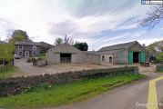
Robin Hood Farm / Google Earth Street View.
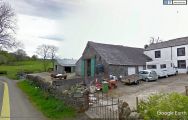
Robin Hood Farm. Name on sign by the gate / Google Earth Street View.
