
Robin Hood Crossroads (Edwinstowe): Difference between revisions
From International Robin Hood Bibliography
mNo edit summary |
mNo edit summary |
||
| Line 20: | Line 20: | ||
<gallery widths="195px"> | <gallery widths="195px"> | ||
geograph-2267179-by-Helmut-Zozmann.jpg|Robin Hood Crossroads with the sign of the Robin Hood / [http://www.geograph.org.uk/photo/2267179 Helmut Zozmann, July 1980; Creative Commons via Geograph.] | geograph-2267179-by-Helmut-Zozmann.jpg|Robin Hood Crossroads with the sign of the Robin Hood / [http://www.geograph.org.uk/photo/2267179 Helmut Zozmann, July 1980; Creative Commons via Geograph.] | ||
geograph-087187-by-Mick-Garratt.jpg|Robin Hood Crossroads, known as such after the pub. Taken from the south west on the B6030 to Clipstone / [http://www.geograph.org.uk/photo/87187 Mick Garratt, 4 Dec. 2005; Creative Commons via Geograph.] | |||
</gallery> | </gallery> | ||
{{PnItemNav}} | {{PnItemNav}} | ||
Revision as of 12:47, 16 October 2018
Robin Hood Crossroads.

Robin Hood Crossroads with the sign of the Robin Hood (1980) / Helmut Zozmann; Creative Commons via Geograph.
By Henrik Thiil Nielsen, 2013-08-07. Revised by Henrik Thiil Nielsen, 2018-10-16.
Template:PnItemQry
The junction in Edwinstowe where the B6030 and B6034 meet is known as the Robin Hood Crossroads. It is named after the Robin Hood pub located there.[1]
It is not known to IRHB how long the crossroads have been named after the Robin Hood pub. The earliest source found so far is Helmut Zozmann's photo shown on this page.
Sources
Notes
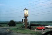
Robin Hood Crossroads with the sign of the Robin Hood / Helmut Zozmann, July 1980; Creative Commons via Geograph.
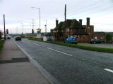
Robin Hood Crossroads, known as such after the pub. Taken from the south west on the B6030 to Clipstone / Mick Garratt, 4 Dec. 2005; Creative Commons via Geograph.
