
Robin Hood Crossroads (Edwinstowe): Difference between revisions
From International Robin Hood Bibliography
mNo edit summary |
mNo edit summary |
||
| Line 1: | Line 1: | ||
__NOTOC__{{PnItemTop|Lat=53.18359|Lon=-1.056816|AdmDiv=Nottinghamshire|Vicinity=Clipstone Road, Edwinstowe, Mansfield|Type=Thoroughfare|Interest=Robin Hood name|Status=Extant|Demonym=|Riding=|GreaterLondon=|Year=1980|Aka=Robin Hood Cross Roads|Century=|Cluster1=Edwinstowe|Cluster2=Sherwood Forest|Cluster3=|Image=geograph-2267179-by-Helmut-Zozmann.jpg|Postcards=|ExtraCat1=|ExtraCat2=|ExtraCat3=|ExtraCat4=|ExtraCat5=|ExtraLink1=|ExtraLink2=|ExtraLink3=|ExtraLink4=|ExtraLink5=|ExtraLinkName1=|ExtraLinkName2=|ExtraLinkName3=|ExtraLinkName4=|ExtraLinkName5=|GeopointPrefix=|GeopointSuffix=|StatusSuffix=|DatePrefix=|DateSuffix=}} | __NOTOC__{{PnItemTop|Lat=53.18359|Lon=-1.056816|AdmDiv=Nottinghamshire|Vicinity=Clipstone Road, Edwinstowe, Mansfield|Type=Thoroughfare|Interest=Robin Hood name|Status=Extant|Demonym=|Riding=|GreaterLondon=|Year=1980|Aka=Robin Hood Cross Roads|Century=|Cluster1=Edwinstowe|Cluster2=Sherwood Forest|Cluster3=|Image=geograph-2267179-by-Helmut-Zozmann.jpg|Postcards=|ExtraCat1=|ExtraCat2=|ExtraCat3=|ExtraCat4=|ExtraCat5=|ExtraLink1=|ExtraLink2=|ExtraLink3=|ExtraLink4=|ExtraLink5=|ExtraLinkName1=|ExtraLinkName2=|ExtraLinkName3=|ExtraLinkName4=|ExtraLinkName5=|GeopointPrefix=|GeopointSuffix=|StatusSuffix=|DatePrefix=|DateSuffix=}} | ||
{{#display_map:{{#var:Coords}}~{{#replace:{{PAGENAME}}|'|'}}|width=34%}}<div class="pnMapLegend">Robin Hood Crossroads.</div> | {{#display_map:{{#var:Coords}}~{{#replace:{{PAGENAME}}|'|'}}|width=34%}}<div class="pnMapLegend">Robin Hood Crossroads.</div> | ||
[[File:geograph-2267179-by-Helmut-Zozmann.jpg|thumb|right|Robin Hood Crossroads with the sign of the Robin Hood (1980) / [http://www.geograph.org.uk/photo/2267179 Helmut Zozmann; Creative Commons via Geograph.]]] | [[File:geograph-2267179-by-Helmut-Zozmann.jpg|thumb|right|500px|Robin Hood Crossroads with the sign of the Robin Hood (1980) / [http://www.geograph.org.uk/photo/2267179 Helmut Zozmann; Creative Commons via Geograph.]]] | ||
<p id="byline">By Henrik Thiil Nielsen, 2013-08-07. Revised by {{#realname:{{REVISIONUSER}}}}, {{REVISIONYEAR}}-{{REVISIONMONTH}}-{{REVISIONDAY2}}.</p> | <p id="byline">By Henrik Thiil Nielsen, 2013-08-07. Revised by {{#realname:{{REVISIONUSER}}}}, {{REVISIONYEAR}}-{{REVISIONMONTH}}-{{REVISIONDAY2}}.</p> | ||
<div class="no-img">{{PnItemQry}} | <div class="no-img">{{PnItemQry}} | ||
Revision as of 12:26, 16 October 2018
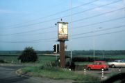
Robin Hood Crossroads.

Robin Hood Crossroads with the sign of the Robin Hood (1980) / Helmut Zozmann; Creative Commons via Geograph.
By Henrik Thiil Nielsen, 2013-08-07. Revised by Henrik Thiil Nielsen, 2018-10-16.
Template:PnItemQry
The junction in Edwinstowe where the B6030 and B6034 meet is known as the Robin Hood Crossroads. It is named after the Robin Hood pub located there.[1]
Sources
Notes
Robin Hood Crossroads with the sign of the Robin Hood (1980) / Helmut Zozmann; Creative Commons via Geograph.