
Robin Hood Croft (Tilstone Fearnall)
| Locality | |
|---|---|
| Coordinate | 53.135068, -2.637534 |
| Adm. div. | Cheshire |
| Vicinity | On N side of Vale Road after its westward turn, c. 115 m S of Nantwich Road (A51), in Tilstone Fearnall |
| Type | Area |
| Interest | Robin Hood name |
| Status | Defunct? |
| First Record | 1840 |

By Henrik Thiil Nielsen, 2021-02-28. Revised by Henrik Thiil Nielsen, 2021-03-01.
A plot of land located immediately west of Robin Hood's Tump in Tilstone Fearnall, Cheshire, was known as 'Robin Hood Croft' in 1840.
The Tump is situated on the northwest corner of Vale Road at the point where the road turns west, c. 115 m south of Nantwich Road (A51). The Croft, immediately west of the Tump, on the north side of Vale Road, figures in the 1840 tithe award for the township of 'Alphraham' (i.e. Alpraham) in the county of Bunbury as 'Robin Hood Croft, with John Tollemache, Esq., as landowner, Richard Lamb as occupier, nothing listed for 'State of Cultivation', but its area cited as 3 roods and 20 perches (3541 m2).[1] We have indicated both plots on the adapted map detail included in the image gallery below.
Gazetteers
- Not included in Dobson, R. B., ed.; Taylor, J., ed. Rymes of Robyn Hood: an Introduction to the English Outlaw (London, 1976), pp. 293-311.
MS sources
- 1840 tithe award for the township of 'Alphraham' (i.e. Alpraham) in the parish of Bunbury, online at the Genealogist, piece 05, sub-piece 010, image 017, #53 (£)
- accompanying map, online at the Genealogist, piece 05, sub-piece 010, sub-image 001, #53 (£).
Maps
- 25" O.S. map Cheshire XLVIII.10 (1875; surveyed 1873)
- 25" O.S. map Cheshire XLVIII.10 (1898; rev. 1897) (georeferenced)
- 25" O.S. map Cheshire XLVIII.10 (1898; rev. 1897)
- 25" O.S. map Cheshire XLVIII.10 (1910; rev. 1908)
- 6" O.S. map Cheshire XLVIII (1881; surveyed 1874)
- 6" O.S. map Cheshire XLVIII.SW (1899; rev. 1897) (georeferenced)
- 6" O.S. map Cheshire XLVIII.SW (1899; rev. 1897)
- 6" O.S. map Cheshire XLVIII.SW (1911; rev. 1908)
- 6" O.S. map Cheshire XLVIII.SW (c. 1935; rev. 1908)
- 6" O.S. map Cheshire XLVIII.SW (c. 1935; rev. 1908)
- 6" O.S. map Cheshire XLVIII.SW (c. 1936; rev. 1908).
Also see
Notes
- ↑ 1840 tithe award for the township of 'Alphraham' (i.e. Alpraham) in the parish of Bunbury, online at the Genealogist, piece 05, sub-piece 010, image 017, #53 (£); accompanying map, online at the Genealogist, piece 05, sub-piece 010, sub-image 001, #53 (£).
Image gallery
Click any image to display it in the lightbox, where you can navigate between images by clicking in the right or left side of the current image.
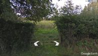
Peeping into (the former) Robin Hood Croft / Google Earth Street View.
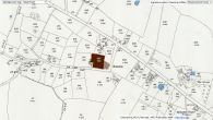
Robin Hood Croft indicated in maroon, Robin Hood 's Tump in brown / Detail of 25" O.S. map Cheshire XVIII.10 (1898; rev. 1897) (georeferenced); reprod. with perm. of NLS; under Creative Commons Attrib. (CC-BY) license; adapt. Henrik Thiil Nielsen.
