Robin Hood Crescent (Knaphill, Woking): Difference between revisions
From International Robin Hood Bibliography
mNo edit summary |
mNo edit summary |
||
| Line 18: | Line 18: | ||
}} | }} | ||
{{#display_map: 51.318996,-0.606102|width=34%}}<div class="pnMapLegend">Robin Hood Crescent.</div> | {{#display_map: 51.318996,-0.606102|width=34%}}<div class="pnMapLegend">Robin Hood Crescent.</div> | ||
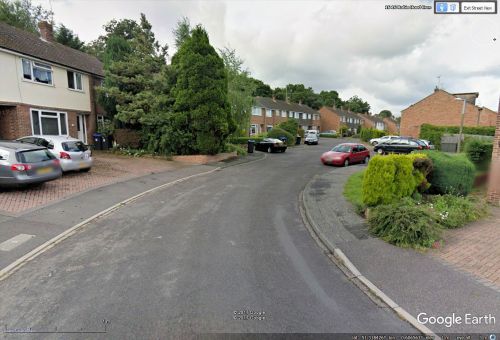
[[File:robin-hood-crescent-knaphill-google-earth-street-view.jpg|thumb|right|500px|/ Google Earth Street View.]] | [[File:robin-hood-crescent-knaphill-google-earth-street-view.jpg|thumb|right|500px|Robin Hood Crescent / Google Earth Street View.]] | ||
<p id="byline">By Henrik Thiil Nielsen, 2013-08-07. Revised by {{#realname:{{REVISIONUSER}}}}, {{REVISIONYEAR}}-{{REVISIONMONTH}}-{{REVISIONDAY2}}.</p><div class="no-img"> | <p id="byline">By Henrik Thiil Nielsen, 2013-08-07. Revised by {{#realname:{{REVISIONUSER}}}}, {{REVISIONYEAR}}-{{REVISIONMONTH}}-{{REVISIONDAY2}}.</p><div class="no-img"> | ||
'Robin Hood Crescent' is the name of a litte residential street in Knaphill connecting [[Robin Hood Road (Knaphill)|Robin Hood Road]] and Beechwood Road. | 'Robin Hood Crescent' is the name of a litte residential street in Knaphill connecting [[Robin Hood Road (Knaphill)|Robin Hood Road]] and Beechwood Road. | ||
Revision as of 07:29, 20 November 2017
| Locality | |
|---|---|
| Coordinates | 51.318996, -0.606102 |
| Adm. div. | Surrey |
| Vicinity | Knaphill, Woking |
| Type | Thoroughfare |
| Interest | Robin Hood name |
| Status | Extant |
| First Record | ? |
Robin Hood Crescent.
By Henrik Thiil Nielsen, 2013-08-07. Revised by Henrik Thiil Nielsen, 2017-11-20.
'Robin Hood Crescent' is the name of a litte residential street in Knaphill connecting Robin Hood Road and Beechwood Road.
Background
Also see
Template:PnItemNav "th" can not be assigned to a declared number type with value 20.

