
Robin Hood Court (Tooley Street): Difference between revisions
mNo edit summary |
m (Text replacement - "ImgGalleryIntro" to "ImageGalleryIntroduction") |
||
| (15 intermediate revisions by 2 users not shown) | |||
| Line 1: | Line 1: | ||
__NOTOC__{{ | __NOTOC__{{PlaceNamesItemTop|Lat=51.505418|Lon=-0.083056|AdministrativeDivision=Surrey|Vicinity=English Grounds, SE from Battle Bridge Lane, NE from Tooley Street|Type=Thoroughfare|Interest=Robin Hood name| | ||
Status=Defunct|Demonym=|Riding=|GreaterLondon=Yes|Year=1763|Aka=|Century=|Cluster1=|Cluster2=|Cluster3=|Image=robin-hood-court-google-earth-street-view.jpg|Postcards=|ExtraCat1=Robinhood place-names|ExtraCat2=Wood for Hood|ExtraCat3=|ExtraCat4=|ExtraCat5=|ExtraLink1=|ExtraLink2=|ExtraLink3=|ExtraLink4=|ExtraLink5=|ExtraLinkName1=|ExtraLinkName2=|ExtraLinkName3=|ExtraLinkName4=|ExtraLinkName5=|GeopointPrefix=|GeopointSuffix=|VicinitySuffix=|StatusSuffix=|DatePrefix=|DateSuffix=}} | Status=Defunct|Demonym=|Riding=|GreaterLondon=Yes|Year=1763|Aka=|Century=|Cluster1=|Cluster2=|Cluster3=|Image=robin-hood-court-google-earth-street-view.jpg|Postcards=|ExtraCat1=Robinhood place-names|ExtraCat2=Wood for Hood|ExtraCat3=|ExtraCat4=|ExtraCat5=|ExtraLink1=|ExtraLink2=|ExtraLink3=|ExtraLink4=|ExtraLink5=|ExtraLinkName1=|ExtraLinkName2=|ExtraLinkName3=|ExtraLinkName4=|ExtraLinkName5=|GeopointPrefix=|GeopointSuffix=|VicinitySuffix=|StatusSuffix=|DatePrefix=|DateSuffix=}} | ||
{{#display_map:{{#var:Coords}}~{{#replace:{{PAGENAME}}|'|'}}|width=34% | {{#display_map:{{#var:Coords}}~{{#replace:{{PAGENAME}}|'|'}}|width=34%|enablefullscreen=yes}}<div class="pnMapLegend">{{PAGENAME}}.</div> | ||
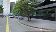
[[File:{{#var: | [[File:{{#var:Image}}|thumb|right|500px|English Grounds, just north of Tooley Street, is the site of Robin Hood Court / Google Earth Street View.]] | ||
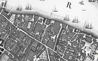
[[File:robin-hood-court-tooley-street-john-rocque-locating-londons-past.jpg|thumb|right|500px|John Rocque's 1746 map of London and Westminster centred on "Robin Woods C[ourt]" / [https://www.locatinglondon.org Locating London's Past.]]] | [[File:robin-hood-court-tooley-street-john-rocque-locating-londons-past.jpg|thumb|right|500px|John Rocque's 1746 map of London and Westminster centred on "Robin Woods C[ourt]" / [https://www.locatinglondon.org Locating London's Past.]]] | ||
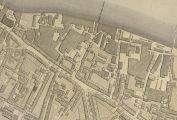
[[File:robin-hood-court-tooley-street-richard-horwood-romantic-london.jpg|thumb|right|500px|Richard Horwood's ''Plan of London'' (1792-99) centred on "Robin Hood Co[urt]" / [http://www.romanticlondon.org/explore-horwoods-plan/#13/51.5081/-0.0972 Romantic London.]]] | [[File:robin-hood-court-tooley-street-richard-horwood-romantic-london.jpg|thumb|right|500px|Richard Horwood's ''Plan of London'' (1792-99) centred on "Robin Hood Co[urt]" / [http://www.romanticlondon.org/explore-horwoods-plan/#13/51.5081/-0.0972 Romantic London.]]]<div class="no-img"> | ||
<p id="byline">By Henrik Thiil Nielsen, 2018-06-24. Revised by {{#realname:{{REVISIONUSER}}}}, {{REVISIONYEAR}}-{{REVISIONMONTH}}-{{REVISIONDAY2}}.</p | <p id="byline">By Henrik Thiil Nielsen, 2018-06-24. Revised by {{#realname:{{REVISIONUSER}}}}, {{REVISIONYEAR}}-{{REVISIONMONTH}}-{{REVISIONDAY2}}.</p> | ||
A Robin Hood Court once existed at what is now English Grounds on the east side of Battle Bridge Lane on the Thames side of Tooley Street. It is first recorded on John Rocque's map of London and Westminster (1746). | A Robin Hood Court once existed at what is now English Grounds on the east side of Battle Bridge Lane on the Thames side of Tooley Street. It is first recorded on John Rocque's map of London and Westminster (1746). | ||
Rocque labels the locality "Robin Woods C[ourt]" (see map detail below). It appears to have been inadvertently included twice in the long list of London street and place-names in the ''Compleat Compting-House Companion'' (1763). On checking the maps, the Companion's "Robin Hood court, Tooley street, Southwark" turns out to be identical with its "Robin Hood court, near Morgan's lane",<ref>{{:Anonymous 1763a}}, pp. 417 ''s.n.'' Robin Hood court [4], 418 ''s.n.'' Robin Hood court [1].</ref> for during the time Battle Bridge was known under the more peaceful-sounding name of Mill Lane, Morgan's Lane was the next side street of Tooley Street towards the east. The same double entry is found in the ''New Complete Guide'' (1783).<ref>{{:Anonymous 1783a}}, ''s.nn.'' Robin Hood's court [4], Robin Hood's court [8].</ref> This of course assumes that there is not somewhere in London yet another Robin Hood Court near another Morgan's Lane. Lockie in his ''Topography of London'' (1810) lists the the locality as "Robinhood-Court, Mill-Lane, Tooley-Street,—the second on the R. a few doors from 55, Tooley-st."<ref>{{:Lockie, John 1810a}}, ''s.n.'' Robinhood-Court [7]</ref> | Rocque labels the locality "Robin Woods C[ourt]" (see map detail below). It appears to have been inadvertently included twice in the long list of London street and place-names in the ''Compleat Compting-House Companion'' (1763). On checking the maps, the Companion's "Robin Hood court, Tooley street, Southwark" turns out to be identical with its "Robin Hood court, near Morgan's lane",<ref>{{:Anonymous 1763a}}, pp. 417 ''s.n.'' Robin Hood court [4], 418 ''s.n.'' Robin Hood court [1].</ref> for during the time Battle Bridge was known under the more peaceful-sounding name of Mill Lane, Morgan's Lane was the next side street of Tooley Street towards the east. The same double entry is found in the ''New Complete Guide'' (1783).<ref>{{:Anonymous 1783a}}, ''s.nn.'' Robin Hood's court [4], Robin Hood's court [8].</ref> This of course assumes that there is not somewhere in London yet another Robin Hood Court near another Morgan's Lane. Lockie in his ''Topography of London'' (1810) lists the the locality as "Robinhood-Court, Mill-Lane, Tooley-Street,—the second on the R. a few doors from 55, Tooley-st."<ref>{{:Lockie, John 1810a}}, ''s.n.'' Robinhood-Court [7]</ref> | ||
{{ | {{PlaceNamesItemAllusionsAndRecords}} | ||
== Gazetteers == | == Gazetteers == | ||
* Not included in {{:Dobson, Richard Barrie 1976a}}, pp. 293-311 | * Not included in {{:Dobson, Richard Barrie 1976a}}, pp. 293-311 | ||
| Line 26: | Line 26: | ||
* [https://maps.nls.uk/view/101919834#zoom=5&lat=9145&lon=4576&layers=BT 25" O.S. map ''London'' (Edition of 1894-96) LXXVII (1897; rev. 1893-94)] | * [https://maps.nls.uk/view/101919834#zoom=5&lat=9145&lon=4576&layers=BT 25" O.S. map ''London'' (Edition of 1894-96) LXXVII (1897; rev. 1893-94)] | ||
* [https://maps.nls.uk/view/103313336#zoom=5&lat=9103&lon=4542&layers=BT 25" O.S. map ''London'' (1915- Numbered sheets) V.15 (1934; rev. 1914)] | * [https://maps.nls.uk/view/103313336#zoom=5&lat=9103&lon=4542&layers=BT 25" O.S. map ''London'' (1915- Numbered sheets) V.15 (1934; rev. 1914)] | ||
* [http://maps.nls.uk/geo/explore/#zoom=18&lat=51.5053&lon=-0.0829&layers=168&b=5 25" O.S. map ''London'' (Edition of 1894-96) LXXVII (1897; rev. 1893-94)] (georeferenced) | * [http://maps.nls.uk/geo/explore/#zoom=18&lat=51.5053&lon=-0.0829&layers=168&b=5 25" O.S. map ''London'' (Edition of 1894-96) LXXVII (1897; rev. 1893-94)] (georeferenced) | ||
* [https://maps.nls.uk/view/102345964#zoom=6&lat=2484&lon=8582&layers=BT 6" O.S. map ''Middlesex'' XVII (1880-82; surveyed 1868-73)] | * [https://maps.nls.uk/view/102345964#zoom=6&lat=2484&lon=8582&layers=BT 6" O.S. map ''Middlesex'' XVII (1880-82; surveyed 1868-73)] | ||
* [https://maps.nls.uk/view/102347415#zoom=7&lat=7187&lon=7644&layers=BT 6" O.S. map ''Surrey'' III (1880; surveyed 1868-73)] | * [https://maps.nls.uk/view/102347415#zoom=7&lat=7187&lon=7644&layers=BT 6" O.S. map ''Surrey'' III (1880; surveyed 1868-73)] | ||
| Line 41: | Line 41: | ||
<!--== Brief mention == | <!--== Brief mention == | ||
* --> | * --> | ||
{{ | {{PlaceNamesItemAlsoSee}} | ||
== Notes == | == Notes == | ||
<references/> | <references/> | ||
</div> | |||
<div id="gallery"> | |||
< | {{ImageGalleryIntroduction}} | ||
{{ | |||
<gallery widths="195px"> | <gallery widths="195px"> | ||
File:robin-hood-court-google-earth-street-view.jpg|English Grounds, just north of Tooley Street, is the site of Robin Hood Court / Google Earth Street View. | File:robin-hood-court-google-earth-street-view.jpg|English Grounds, just north of Tooley Street, is the site of Robin Hood Court / Google Earth Street View. | ||
| Line 54: | Line 54: | ||
File:robin-hood-court-tooley-street-richard-horwood-romantic-london.jpg|Richard Horwood's ''Plan of London'' (1792-99) centred on "Robin Hood Co[urt]" / [http://www.romanticlondon.org/explore-horwoods-plan/#13/51.5081/-0.0972 Romantic London.] | File:robin-hood-court-tooley-street-richard-horwood-romantic-london.jpg|Richard Horwood's ''Plan of London'' (1792-99) centred on "Robin Hood Co[urt]" / [http://www.romanticlondon.org/explore-horwoods-plan/#13/51.5081/-0.0972 Romantic London.] | ||
</gallery> | </gallery> | ||
</div> | |||
{{PlaceNamesItemNavigation}} | |||
{{ | |||
Latest revision as of 13:53, 7 January 2021
| Locality | |
|---|---|
| Coordinate | 51.505418, -0.083056 |
| Adm. div. | Surrey, now Greater London |
| Vicinity | English Grounds, SE from Battle Bridge Lane, NE from Tooley Street |
| Type | Thoroughfare |
| Interest | Robin Hood name |
| Status | Defunct |
| First Record | 1763 |


By Henrik Thiil Nielsen, 2018-06-24. Revised by Henrik Thiil Nielsen, 2021-01-07.
A Robin Hood Court once existed at what is now English Grounds on the east side of Battle Bridge Lane on the Thames side of Tooley Street. It is first recorded on John Rocque's map of London and Westminster (1746).
Rocque labels the locality "Robin Woods C[ourt]" (see map detail below). It appears to have been inadvertently included twice in the long list of London street and place-names in the Compleat Compting-House Companion (1763). On checking the maps, the Companion's "Robin Hood court, Tooley street, Southwark" turns out to be identical with its "Robin Hood court, near Morgan's lane",[1] for during the time Battle Bridge was known under the more peaceful-sounding name of Mill Lane, Morgan's Lane was the next side street of Tooley Street towards the east. The same double entry is found in the New Complete Guide (1783).[2] This of course assumes that there is not somewhere in London yet another Robin Hood Court near another Morgan's Lane. Lockie in his Topography of London (1810) lists the the locality as "Robinhood-Court, Mill-Lane, Tooley-Street,—the second on the R. a few doors from 55, Tooley-st."[3]
Gazetteers
- Not included in Dobson, R. B., ed.; Taylor, J., ed. Rymes of Robyn Hood: an Introduction to the English Outlaw (London, 1976), pp. 293-311
Sources
- Anonymous. The Compleat Compting-House Companion: or, Young Merchant, or Tradesman's Sure Guide (London, 1763), pp. 417 s.n. Robin Hood court [4], 418 s.n. Robin Hood court [1]
- Anonymous, compil. The New Complete Guide to all Persons who have any Trade or Concern with the City of London, and Parts adjacent ([s.l], 1783), s.nn. Robin Hood's court [4], Robin Hood's court [8]
- Elmes, James, compil. A Topographical Dictionary of London and Its Environs (London, 1831), p. 354 s.n. Robinhood-Ct.
- Lockie, John, compil. Lockie's Topography of London, Giving a Concise Local Description of and Accurate Direction to Every Square, Street, Lane, Court, Dock, Wharf, Inn, Public Office, &c. in the Metropolis and its Environs (London, 1810), s.n. Robinhood-Court [7]
Maps
- Horwood, John. Plan of London and Westminster. Online at: Romantic London
- Rocque, John, cartog.; Pine, John, engr. A Plan of the Cities of London and Westminster, and Borough of Southwark (London, 1746). Online at: Locating London's Past
- 25" O.S. map London (First Editions c1850s) XLV (1878; surveyed 1872)
- 25" O.S. map London (Edition of 1894-96) LXXVII (1897; rev. 1893-94)
- 25" O.S. map London (1915- Numbered sheets) V.15 (1934; rev. 1914)
- 25" O.S. map London (Edition of 1894-96) LXXVII (1897; rev. 1893-94) (georeferenced)
- 6" O.S. map Middlesex XVII (1880-82; surveyed 1868-73)
- 6" O.S. map Surrey III (1880; surveyed 1868-73)
- 6" O.S. map London VII.SE (1894-96; rev. 1893-94)
- 6" O.S. map Surrey III.NW (1898; rev. 1893-95)
- 6" O.S. map Surrey III.NW (1898; rev. 1893-95) (georeferenced)
- 6" O.S. map London Sheet K (1920; rev. 1913-14)
- 6" O.S. map London Sheet K (c. 1946; rev. 1938).
Also see
Notes
- ↑ Anonymous. The Compleat Compting-House Companion: or, Young Merchant, or Tradesman's Sure Guide (London, 1763), pp. 417 s.n. Robin Hood court [4], 418 s.n. Robin Hood court [1].
- ↑ Anonymous, compil. The New Complete Guide to all Persons who have any Trade or Concern with the City of London, and Parts adjacent ([s.l], 1783), s.nn. Robin Hood's court [4], Robin Hood's court [8].
- ↑ Lockie, John, compil. Lockie's Topography of London, Giving a Concise Local Description of and Accurate Direction to Every Square, Street, Lane, Court, Dock, Wharf, Inn, Public Office, &c. in the Metropolis and its Environs (London, 1810), s.n. Robinhood-Court [7]
Image gallery
Click any image to display it in the lightbox, where you can navigate between images by clicking in the right or left side of the current image.
English Grounds, just north of Tooley Street, is the site of Robin Hood Court / Google Earth Street View.
John Rocque's 1746 map of London and Westminster centred on "Robin Woods C[ourt]" / Locating London's Past.
Richard Horwood's Plan of London (1792-99) centred on "Robin Hood Co[urt]" / Romantic London.