
Robin Hood Court (St Giles): Difference between revisions
m (Text replacement - "{{#ask:[[Category:Records ({{#ifeq:{{#pos:{{PAGENAME}}|(|}}||{{PAGENAME}}|{{#sub:{{PAGENAME}}|0| {{#expr:{{#pos:{{PAGENAME}}|(|}}-1}} }},{{#sub:{{PAGENAME}}|{{#expr:{{#pos:{{PAGENAME}}|(|}}-1}}|1}}{{#sub:{{PAGENAME}}|{{#expr:{{#pos:...) |
m (Text replacement - "ImgGalleryIntro" to "ImageGalleryIntroduction") |
||
| (17 intermediate revisions by 2 users not shown) | |||
| Line 1: | Line 1: | ||
__NOTOC__{{ | __NOTOC__{{PlaceNamesItemTop|Lat=51.5163|Lon=-0.1276|AdministrativeDivision=Middlesex|Vicinity=Church Lane, St Giles; Slightly W of Dyott Street and S of Bucknall Street; between New Oxford Street and Shaftesbury Avenue|Type=Area|Interest=Robin Hood name| | ||
Status=Defunct|Demonym=|Riding=|GreaterLondon=Yes|Year=1810|Aka=|Century=|Cluster1=St Giles|Cluster2=|Cluster3=|Image=robin-hood-st-giles-google-earth-street-view-2.jpg|Postcards=|ExtraCat1=Robinhood place-names|ExtraCat2=|ExtraCat3=|ExtraCat4=|ExtraCat5=|ExtraLink1=|ExtraLink2=|ExtraLink3=|ExtraLink4=|ExtraLink5=|ExtraLinkName1=|ExtraLinkName2=|ExtraLinkName3=|ExtraLinkName4=|Extraordinaire=|GeopointPrefix=Near |GeopointSuffix=|VicinitySuffix=|StatusSuffix=|DatePrefix=|DateSuffix=}} | Status=Defunct|Demonym=|Riding=|GreaterLondon=Yes|Year=1810|Aka=|Century=|Cluster1=St Giles|Cluster2=|Cluster3=|Image=robin-hood-st-giles-google-earth-street-view-2.jpg|Postcards=|ExtraCat1=Robinhood place-names|ExtraCat2=|ExtraCat3=|ExtraCat4=|ExtraCat5=|ExtraLink1=|ExtraLink2=|ExtraLink3=|ExtraLink4=|ExtraLink5=|ExtraLinkName1=|ExtraLinkName2=|ExtraLinkName3=|ExtraLinkName4=|Extraordinaire=|GeopointPrefix=Near |GeopointSuffix=|VicinitySuffix=|StatusSuffix=|DatePrefix=|DateSuffix=}} | ||
{{#display_map:{{#var:Coords}}~{{#replace:{{PAGENAME}}|'|'}}|width=34%}}<div class="pnMapLegend">Robin Hood Court was somewhere near the point indicated.</div> | {{#display_map:{{#var:Coords}}~{{#replace:{{PAGENAME}}|'|'}}|width=34%|enablefullscreen=yes}}<div class="pnMapLegend">Robin Hood Court was somewhere near the point indicated.</div> | ||
[[File:robin-hood-court-st-giles-google-earth-street-view.jpg|thumb|right|500px|Robin Hood Court was quite close to this spot, perhaps a little south of it / Google Earth Street View.]] | [[File:robin-hood-court-st-giles-google-earth-street-view.jpg|thumb|right|500px|Robin Hood Court was quite close to this spot, perhaps a little south of it / Google Earth Street View.]] | ||
[[File:{{#var: | [[File:{{#var:Image}}|thumb|right|500px|The most likely site of the Robin Hood / Google Earth Street View.]] | ||
[[File:robin-hood-court-st-giles-os-25.jpg|thumb|right|500px|The exact location of Robin Hood Yard is not known, but the red arrow points to what seems the most likely spot / Google Earth Street View.]] | [[File:robin-hood-court-st-giles-os-25.jpg|thumb|right|500px|The exact location of Robin Hood Yard is not known, but the red arrow points to what seems the most likely spot / Google Earth Street View.]]<div class="no-img"> | ||
<p id="byline">By Henrik Thiil Nielsen, 2018-06-23. Revised by {{#realname:{{REVISIONUSER}}}}, {{REVISIONYEAR}}-{{REVISIONMONTH}}-{{REVISIONDAY2}}.</p | <p id="byline">By Henrik Thiil Nielsen, 2018-06-23. Revised by {{#realname:{{REVISIONUSER}}}}, {{REVISIONYEAR}}-{{REVISIONMONTH}}-{{REVISIONDAY2}}.</p> | ||
Robin Hood Court was a small cul-de-sac not far from the southern end of Bucknall Street and thus near Dyott Street. It is known only from early 19th century topographical reference works. | Robin Hood Court was a small cul-de-sac not far from the southern end of Bucknall Street and thus near Dyott Street. It is known only from early 19th century topographical reference works. | ||
When dealing with localities in this area it is good to know that street layout and nomenclature underwent considerable changes from the mid-18th century to the 20th century. For this see the page on the nearby [[Robin Hood (St Giles)|Robin Hood pub]]. John Lockie in his ''Topography of London'' (1810) lists the court as "Robinhood-Court, Church-Lane, St. Giles's,—about four doors on the L. from Diot-street, near Phænix-street".<ref>{{:Lockie, John 1810a}}, ''s.n.'' Robinhood-Court [I].</ref> In the 1813 edition this has been update to take account of recent changes in street layout and nomenclature: "Robinhood Court, Church Lane,—4 doors from George-st. Bloomsbury".<ref>{{:Lockie, John 1813a}}, ''s.n.'' Robinhood Court [I].</ref> It is also included in James Elmes's ''Topographical Dictionary of London'' (1831),<ref>{{:Elmes, James 1831a}}, ''s.n.'' Robinhood-Ct.</ref> but without any detail that could help us locate it. Of all the maps I have consulted I think only the 25" O.S. map published 1875 and surveyed 1870 can help us pinpoint Robin Hood Court. The yard I have indicated with a red arrow on the map detail below answers rather well to Lockie's directions. I think this was Robin Hood Yard and the Robin Hood was house in the building between it and Bucknall Street (formerly Church Lane and Church Street). It seems certain, at least, that the pub and court would have been within what is now known as Central Saint Giles Piazza.{{ | When dealing with localities in this area it is good to know that street layout and nomenclature underwent considerable changes from the mid-18th century to the 20th century. For this see the page on the nearby [[Robin Hood (St Giles)|Robin Hood pub]]. John Lockie in his ''Topography of London'' (1810) lists the court as "Robinhood-Court, Church-Lane, St. Giles's,—about four doors on the L. from Diot-street, near Phænix-street".<ref>{{:Lockie, John 1810a}}, ''s.n.'' Robinhood-Court [I].</ref> In the 1813 edition this has been update to take account of recent changes in street layout and nomenclature: "Robinhood Court, Church Lane,—4 doors from George-st. Bloomsbury".<ref>{{:Lockie, John 1813a}}, ''s.n.'' Robinhood Court [I].</ref> It is also included in James Elmes's ''Topographical Dictionary of London'' (1831),<ref>{{:Elmes, James 1831a}}, ''s.n.'' Robinhood-Ct.</ref> but without any detail that could help us locate it. Of all the maps I have consulted I think only the 25" O.S. map published 1875 and surveyed 1870 can help us pinpoint Robin Hood Court. The yard I have indicated with a red arrow on the map detail below answers rather well to Lockie's directions. I think this was Robin Hood Yard and the Robin Hood was house in the building between it and Bucknall Street (formerly Church Lane and Church Street). It seems certain, at least, that the pub and court would have been within what is now known as Central Saint Giles Piazza.{{PlaceNamesItemAllusionsAndRecords}} | ||
== Gazetteers == | == Gazetteers == | ||
* Not included in {{:Dobson, Richard Barrie 1976a}}, pp. 293-311. | * Not included in {{:Dobson, Richard Barrie 1976a}}, pp. 293-311. | ||
| Line 21: | Line 21: | ||
* [https://maps.nls.uk/view/103313021#zoom=6&lat=6827&lon=15290&layers=BT 25" O.S. map ''London'' (First Editions c1850s) XXXIV (1875; surveyed 1870)] | * [https://maps.nls.uk/view/103313021#zoom=6&lat=6827&lon=15290&layers=BT 25" O.S. map ''London'' (First Editions c1850s) XXXIV (1875; surveyed 1870)] | ||
* [https://maps.nls.uk/view/103313318#zoom=5&lat=6696&lon=15522&layers=BT 25" O.S. map ''London'' (1915- Numbered sheets) V.9 (1934; rev. 1914)] | * [https://maps.nls.uk/view/103313318#zoom=5&lat=6696&lon=15522&layers=BT 25" O.S. map ''London'' (1915- Numbered sheets) V.9 (1934; rev. 1914)] | ||
* [http://maps.nls.uk/geo/explore/#zoom=18&lat=51.5163&lon=-0.1278&layers=168&b=5 25" O.S. map ''London'' (1915- Numbered sheets) V.9 (1934; rev. 1914)] (georeferenced) | * [http://maps.nls.uk/geo/explore/#zoom=18&lat=51.5163&lon=-0.1278&layers=168&b=5 25" O.S. map ''London'' (1915- Numbered sheets) V.9 (1934; rev. 1914)] (georeferenced) | ||
* [https://maps.nls.uk/view/102345964#zoom=7&lat=4417&lon=3939&layers=BT 6" O.S. map ''Middlesex'' XVII (1880-82; surveyed 1868-73)] | * [https://maps.nls.uk/view/102345964#zoom=7&lat=4417&lon=3939&layers=BT 6" O.S. map ''Middlesex'' XVII (1880-82; surveyed 1868-73)] | ||
* [https://maps.nls.uk/view/102347415#zoom=7&lat=9027&lon=2963&layers=BT 6" O.S. map ''Surrey'' III (1880; surveyed 1868-73)] | * [https://maps.nls.uk/view/102347415#zoom=7&lat=9027&lon=2963&layers=BT 6" O.S. map ''Surrey'' III (1880; surveyed 1868-73)] | ||
| Line 36: | Line 36: | ||
<!--== Brief mention == | <!--== Brief mention == | ||
* --> | * --> | ||
{{ | {{PlaceNamesItemAlsoSee}} | ||
== Notes == | == Notes == | ||
<references/> | <references/> | ||
</div> | |||
<div id="gallery"> | |||
< | {{ImageGalleryIntroduction}} | ||
{{ | |||
<gallery widths="195px"> | <gallery widths="195px"> | ||
File:robin-hood-court-st-giles-google-earth-street-view.jpg|Robin Hood Court was quite close to this spot, perhaps a little south of it / Google Earth Street View. | File:robin-hood-court-st-giles-google-earth-street-view.jpg|Robin Hood Court was quite close to this spot, perhaps a little south of it / Google Earth Street View. | ||
| Line 50: | Line 49: | ||
File:robin-hood-court-st-giles-os-25.jpg|thumb|right|500px|The exact location of Robin Hood Yard is not known, but the red arrow points to what seems the most likely spot / Google Earth Street View. | File:robin-hood-court-st-giles-os-25.jpg|thumb|right|500px|The exact location of Robin Hood Yard is not known, but the red arrow points to what seems the most likely spot / Google Earth Street View. | ||
</gallery> | </gallery> | ||
</div> | |||
{{PlaceNamesItemNavigation}} | |||
{{ | |||
Latest revision as of 13:53, 7 January 2021
| Locality | |
|---|---|
| Coordinate | Near 51.5163, -0.1276 |
| Adm. div. | Middlesex, now Greater London |
| Vicinity | Church Lane, St Giles; Slightly W of Dyott Street and S of Bucknall Street; between New Oxford Street and Shaftesbury Avenue |
| Type | Area |
| Interest | Robin Hood name |
| Status | Defunct |
| First Record | 1810 |


By Henrik Thiil Nielsen, 2018-06-23. Revised by Henrik Thiil Nielsen, 2021-01-07.
Robin Hood Court was a small cul-de-sac not far from the southern end of Bucknall Street and thus near Dyott Street. It is known only from early 19th century topographical reference works.
When dealing with localities in this area it is good to know that street layout and nomenclature underwent considerable changes from the mid-18th century to the 20th century. For this see the page on the nearby Robin Hood pub. John Lockie in his Topography of London (1810) lists the court as "Robinhood-Court, Church-Lane, St. Giles's,—about four doors on the L. from Diot-street, near Phænix-street".[1] In the 1813 edition this has been update to take account of recent changes in street layout and nomenclature: "Robinhood Court, Church Lane,—4 doors from George-st. Bloomsbury".[2] It is also included in James Elmes's Topographical Dictionary of London (1831),[3] but without any detail that could help us locate it. Of all the maps I have consulted I think only the 25" O.S. map published 1875 and surveyed 1870 can help us pinpoint Robin Hood Court. The yard I have indicated with a red arrow on the map detail below answers rather well to Lockie's directions. I think this was Robin Hood Yard and the Robin Hood was house in the building between it and Bucknall Street (formerly Church Lane and Church Street). It seems certain, at least, that the pub and court would have been within what is now known as Central Saint Giles Piazza.
Gazetteers
- Not included in Dobson, R. B., ed.; Taylor, J., ed. Rymes of Robyn Hood: an Introduction to the English Outlaw (London, 1976), pp. 293-311.
Sources
- Elmes, James, compil. A Topographical Dictionary of London and Its Environs (London, 1831), p. 354, s.n. Robinhood-Ct.
- Lockie, John, compil. Lockie's Topography of London, Giving a Concise Local Description of and Accurate Direction to Every Square, Street, Lane, Court, Dock, Wharf, Inn, Public Office, &c. in the Metropolis and its Environs (London, 1810), s.n. Robinhood-Court [I]
- Lockie, John, compil. Lockie's Topography of London, Giving a Concise Local Description of, and Accurate Direction to, Every Square, Street, Lane, Court, Dock, Wharf, Inn, Public Office, &c. in the Metropolis and its Environs. Second Edition (London, 1813), s.n. Robinhood Court [I].
Maps
- Rocque, John, cartog.; Pine, John, engr. A Plan of the Cities of London and Westminster, and Borough of Southwark (London, 1746). Online at Locating London's Past
- Horwood, Richard. Plan of the Cities of London and Westminster, the Borough of Southwark, and Parts Adjoining" (1792-99) / at Romantic London
- Edward Stanford's Library Map of London and its Suburbs (1862-71): Bloomsbury
- 25" O.S. map London (First Editions c1850s) XXXIV (1875; surveyed 1870)
- 25" O.S. map London (1915- Numbered sheets) V.9 (1934; rev. 1914)
- 25" O.S. map London (1915- Numbered sheets) V.9 (1934; rev. 1914) (georeferenced)
- 6" O.S. map Middlesex XVII (1880-82; surveyed 1868-73)
- 6" O.S. map Surrey III (1880; surveyed 1868-73)
- 6" O.S. map London VII.SW (1894-96; rev. 1893-95)
- 6" O.S. map Surrey III.NW (1898; rev. 1893-95)
- 6" O.S. map Surrey III.NW (1898; rev. 1893-95) (georeferenced)
- 6" O.S. map London Sheet K (1920; rev. 1913-14)
- 6" O.S. map London Sheet K (c. 1946; rev. 1938).
Background
Also see
Notes
- ↑ Lockie, John, compil. Lockie's Topography of London, Giving a Concise Local Description of and Accurate Direction to Every Square, Street, Lane, Court, Dock, Wharf, Inn, Public Office, &c. in the Metropolis and its Environs (London, 1810), s.n. Robinhood-Court [I].
- ↑ Lockie, John, compil. Lockie's Topography of London, Giving a Concise Local Description of, and Accurate Direction to, Every Square, Street, Lane, Court, Dock, Wharf, Inn, Public Office, &c. in the Metropolis and its Environs. Second Edition (London, 1813), s.n. Robinhood Court [I].
- ↑ Elmes, James, compil. A Topographical Dictionary of London and Its Environs (London, 1831), s.n. Robinhood-Ct.
Image gallery
Click any image to display it in the lightbox, where you can navigate between images by clicking in the right or left side of the current image.

Robin Hood Court was quite close to this spot, perhaps a little south of it / Google Earth Street View.
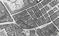
Church Street and Lane on John Rocque's 1746 map of London. By the time Lockie compiled his Topography they had exchanged names / Locating London's Past.
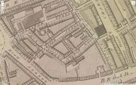
Church Street and Lane on Richard Horwood's Plan of the Cities of London and Westminster (1792-99) / Romantic London: Explore Horwood's Plan.
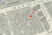
The exact location of Robin Hood Yard is not known, but the red arrow points to what seems the most likely spot / Google Earth Street View.

