
Robin Hood Court (St Clement Danes): Difference between revisions
m (Text replacement - "|service=leaflet}}" to "|service=leaflet|enablefullscreen=yes}}") |
mNo edit summary |
||
| Line 9: | Line 9: | ||
Robin Hood Court is included in a list of localities in the ''Compleat Compting House Companion'' (1763).<ref>{{:Anonymous 1763a}}, p. 417, ''s.n.'' Robin Hood court [6].</ref> Lockie in his ''Topography of London'' (editions of 1810 and 1813) notes a ""Robinhood-Court, Newcastle-Court, Strand,—the first on the L., a few yards from Picket-st. or the Strand, near Temple-bar" (see Gazetteers below). "Picket Street" was then the name of the Strand on the north side of the church of St Clement Danes.<ref>See [http://www.mappalondon.com/london/north-west/westminster.jpg Edward Stanford's ''Library Map of London'' (1862-71), Westminster section.]</ref> Based on Lockie's directions I believe the yard indicated on the detail of Horwood's map below is likely to be the one he referred to. | Robin Hood Court is included in a list of localities in the ''Compleat Compting House Companion'' (1763).<ref>{{:Anonymous 1763a}}, p. 417, ''s.n.'' Robin Hood court [6].</ref> Lockie in his ''Topography of London'' (editions of 1810 and 1813) notes a ""Robinhood-Court, Newcastle-Court, Strand,—the first on the L., a few yards from Picket-st. or the Strand, near Temple-bar" (see Gazetteers below). "Picket Street" was then the name of the Strand on the north side of the church of St Clement Danes.<ref>See [http://www.mappalondon.com/london/north-west/westminster.jpg Edward Stanford's ''Library Map of London'' (1862-71), Westminster section.]</ref> Based on Lockie's directions I believe the yard indicated on the detail of Horwood's map below is likely to be the one he referred to. | ||
There was another Robin Hood Court on the north side of the Strand, for this see [[Robin Hood Court (St Martin-in-the-Fields)]].{{PnItemQry}} | There was another Robin Hood Court on the north side of the Strand, for this see [[Robin Hood Court (St Martin-in-the-Fields)]]. | ||
{{PnItemQry}} | |||
== Gazetteers == | == Gazetteers == | ||
* Not included in {{:Dobson, Richard Barrie 1976a}}, pp. 293-311. | |||
== Sources == | |||
* {{:Anonymous 1763a}}, p. 417, ''s.n.'' Robin Hood court [6] | * {{:Anonymous 1763a}}, p. 417, ''s.n.'' Robin Hood court [6] | ||
* {{:Anonymous 1783a}}, p. 59 ''s.n.'' Robin Hood's court [6] | * {{:Anonymous 1783a}}, p. 59 ''s.n.'' Robin Hood's court [6] | ||
* {{:Elmes, James 1831a}}, p. 354, ''s.n.'' Robinhood-Ct. | * {{:Elmes, James 1831a}}, p. 354, ''s.n.'' Robinhood-Ct. | ||
* {{:Lockie, John 1810a}}, ''s.n.'' Robinhood-Court [2] | * {{:Lockie, John 1810a}}, ''s.n.'' Robinhood-Court [2] | ||
** {{:Lockie, John 1813a}}, ''s.n.'' Robinhood-Court [2] | ** {{:Lockie, John 1813a}}, ''s.n.'' Robinhood-Court [2]. | ||
== Maps == | == Maps == | ||
* [http://www.mappalondon.com/london/north-west/westminster.jpg Edward Stanford's ''Library Map of London'' (1862-71), Westminster section] | * [http://www.mappalondon.com/london/north-west/westminster.jpg Edward Stanford's ''Library Map of London'' (1862-71), Westminster section] | ||
* [https://maps.nls.uk/view/103313321#zoom=5&lat=4670&lon=6141&layers=BT 25" O.S. map ''London'' (1915- Numbered sheets) V.10 (1936; rev. 1914)] | * [https://maps.nls.uk/view/103313321#zoom=5&lat=4670&lon=6141&layers=BT 25" O.S. map ''London'' (1915- Numbered sheets) V.10 (1936; rev. 1914)] | ||
* [http://maps.nls.uk/geo/explore/#zoom=17&lat=51.5141&lon=-0.1146&layers=168&b=5 25" O.S. map ''London'' (1915- Numbered sheets) V.10 (1936; rev. 1914)] (georeferenced) | * [http://maps.nls.uk/geo/explore/#zoom=17&lat=51.5141&lon=-0.1146&layers=168&b=5 25" O.S. map ''London'' (1915- Numbered sheets) V.10 (1936; rev. 1914)] (georeferenced) | ||
* [https://maps.nls.uk/view/102345964#zoom=6&lat=3986&lon=5379&layers=BT 6" O.S. map ''Middlesex'' XVII (1880-82; surveyed 1868-73)] | * [https://maps.nls.uk/view/102345964#zoom=6&lat=3986&lon=5379&layers=BT 6" O.S. map ''Middlesex'' XVII (1880-82; surveyed 1868-73)] | ||
* [https://maps.nls.uk/view/102347415#zoom=6&lat=8587&lon=4459&layers=BT 6" O.S. map ''Surrey'' III (1880; surveyed 1868-73)] | * [https://maps.nls.uk/view/102347415#zoom=6&lat=8587&lon=4459&layers=BT 6" O.S. map ''Surrey'' III (1880; surveyed 1868-73)] | ||
Revision as of 17:18, 31 May 2019
[[File:|thumb|right|500px|The Robin Hood Court was probably located somewhere within the area now occupied by the Royal Courts of Justice / Google Earth Street View.]]

By Henrik Thiil Nielsen, 2018-06-23. Revised by Henrik Thiil Nielsen, 2019-05-31.
Robin Hood Court was located a little north-east of the church of St Clement Danes in an area now occupied by the Royal Courts of Justice. It is noted in mid-18th to early 19th century topographical reference works on London.
Robin Hood Court is included in a list of localities in the Compleat Compting House Companion (1763).[1] Lockie in his Topography of London (editions of 1810 and 1813) notes a ""Robinhood-Court, Newcastle-Court, Strand,—the first on the L., a few yards from Picket-st. or the Strand, near Temple-bar" (see Gazetteers below). "Picket Street" was then the name of the Strand on the north side of the church of St Clement Danes.[2] Based on Lockie's directions I believe the yard indicated on the detail of Horwood's map below is likely to be the one he referred to.
There was another Robin Hood Court on the north side of the Strand, for this see Robin Hood Court (St Martin-in-the-Fields). Template:PnItemQry
Gazetteers
- Not included in Dobson, R. B., ed.; Taylor, J., ed. Rymes of Robyn Hood: an Introduction to the English Outlaw (London, 1976), pp. 293-311.
Sources
- Anonymous. The Compleat Compting-House Companion: or, Young Merchant, or Tradesman's Sure Guide (London, 1763), p. 417, s.n. Robin Hood court [6]
- Anonymous, compil. The New Complete Guide to all Persons who have any Trade or Concern with the City of London, and Parts adjacent ([s.l], 1783), p. 59 s.n. Robin Hood's court [6]
- Elmes, James, compil. A Topographical Dictionary of London and Its Environs (London, 1831), p. 354, s.n. Robinhood-Ct.
- Lockie, John, compil. Lockie's Topography of London, Giving a Concise Local Description of and Accurate Direction to Every Square, Street, Lane, Court, Dock, Wharf, Inn, Public Office, &c. in the Metropolis and its Environs (London, 1810), s.n. Robinhood-Court [2]
Maps
- Edward Stanford's Library Map of London (1862-71), Westminster section
- 25" O.S. map London (1915- Numbered sheets) V.10 (1936; rev. 1914)
- 25" O.S. map London (1915- Numbered sheets) V.10 (1936; rev. 1914) (georeferenced)
- 6" O.S. map Middlesex XVII (1880-82; surveyed 1868-73)
- 6" O.S. map Surrey III (1880; surveyed 1868-73)
- 6" O.S. map London VII.SW (1894-96; rev. 1893-95)
- 6" O.S. map Surrey III.NW (1898; rev. 1893-95)
- 6" O.S. map Surrey III.NW (1898; rev. 1893-95) (georeferenced)
- 6" O.S. map London Sheet K (1920; rev. 1913-14)
- 6" O.S. map London Sheet K (c. 1946; rev. 1938).
Background
Notes
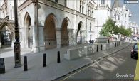
The Robin Hood Court was probably located somewhere within the area now occupied by the Royal Courts of Justice / Google Earth Street View.
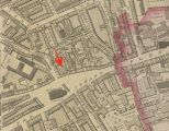
Robin Hood Court was probably the area indicated by the red arrow / Adapted from Richard Horwood's Plan of the Cities of London and Westminster (1792-99) at Romantic London.
