
Robin Hood Court (Bow Lane): Difference between revisions
m (Text replacement - "|service=leaflet}}" to "|service=leaflet|enablefullscreen=yes}}") |
mNo edit summary |
||
| Line 10: | Line 10: | ||
{{PnItemQry}} | {{PnItemQry}} | ||
== Gazetteers == | == Gazetteers == | ||
* {{:Dobson, Richard Barrie 1976a}}, p. 299. Robin Hood Court [1] | |||
== Sources == | |||
* {{:Anonymous 1728a}}, p. 30, ''s.n.'' 'Robin hood's court' | * {{:Anonymous 1728a}}, p. 30, ''s.n.'' 'Robin hood's court' | ||
* {{:Anonymous 1763a}}, p. 417, ''s.n.'' Robin Hood court [2] | * {{:Anonymous 1763a}}, p. 417, ''s.n.'' Robin Hood court [2] | ||
* {{:Anonymous 1783a}}, p. 59 ''s.n.'' Robin Hood's court [2] | * {{:Anonymous 1783a}}, p. 59 ''s.n.'' Robin Hood's court [2] | ||
* {{:Company of Parish-Clerks, The 1732a}}, ''s.n.'' Robin Hood's court | * {{:Company of Parish-Clerks, The 1732a}}, ''s.n.'' Robin Hood's court | ||
* {{:Elmes, James 1831a}}, p. 354 ''s.n.'' Robinhood-Ct. | * {{:Elmes, James 1831a}}, p. 354 ''s.n.'' Robinhood-Ct. | ||
* {{:Harben, Henry Andrade 1918a}}, p. 505, ''s.n.'' Robin Hood Court [1] | * {{:Harben, Henry Andrade 1918a}}, p. 505, ''s.n.'' Robin Hood Court [1] | ||
* {{:Lockie, John 1810a}}, ''s.n.'' Robinhood-Court [4] | * {{:Lockie, John 1810a}}, ''s.n.'' Robinhood-Court [4] | ||
** {{:Lockie, John 1813a}}, ''s.n.'' Robinhood-Court [4]. | ** {{:Lockie, John 1813a}}, ''s.n.'' Robinhood-Court [4]. | ||
== Maps == | == Maps == | ||
* {{:Ogilby, John 1677a}}. See discussion above | * {{:Ogilby, John 1677a}}. See discussion above | ||
** [http://www.british-history.ac.uk/no-series/london-map-ogilby-morgan/1676 British History Online] | ** [http://www.british-history.ac.uk/no-series/london-map-ogilby-morgan/1676 British History Online] | ||
** [http://british-library.georeferencer.com/map/tZhzP2P0wma4LPL34zCGXs/201407121539-l8vhPJ/visualize British Library: Online Gallery] (zoomable overlay) | ** [http://british-library.georeferencer.com/map/tZhzP2P0wma4LPL34zCGXs/201407121539-l8vhPJ/visualize British Library: Online Gallery] (zoomable overlay) | ||
| Line 29: | Line 29: | ||
** [https://upload.wikimedia.org/wikipedia/commons/e/e5/Maps_Of_Old_London_Ogilby.jpg Wikimedia Commons: Maps of Old London: Ogilby.] | ** [https://upload.wikimedia.org/wikipedia/commons/e/e5/Maps_Of_Old_London_Ogilby.jpg Wikimedia Commons: Maps of Old London: Ogilby.] | ||
* [https://maps.nls.uk/view/103313321#zoom=5&lat=3959&lon=15085&layers=BT 25" O.S. map ''London'' (1915- Numbered sheets) V.10 (1936; rev. 1914)] | * [https://maps.nls.uk/view/103313321#zoom=5&lat=3959&lon=15085&layers=BT 25" O.S. map ''London'' (1915- Numbered sheets) V.10 (1936; rev. 1914)] | ||
* [http://maps.nls.uk/geo/explore/#zoom=19&lat=51.5124&lon=-0.0935&layers=168&b=5 25" O.S. map ''London'' (1915- Numbered sheets) V.10 (1936; rev. 1914)] (georeferenced) | * [http://maps.nls.uk/geo/explore/#zoom=19&lat=51.5124&lon=-0.0935&layers=168&b=5 25" O.S. map ''London'' (1915- Numbered sheets) V.10 (1936; rev. 1914)] (georeferenced) | ||
* [https://maps.nls.uk/view/102345964#zoom=6&lat=3750&lon=7643&layers=BT 6" O.S. map ''Middlesex'' XVII (1880-82; surveyed 1868-73)] | * [https://maps.nls.uk/view/102345964#zoom=6&lat=3750&lon=7643&layers=BT 6" O.S. map ''Middlesex'' XVII (1880-82; surveyed 1868-73)] | ||
* [https://maps.nls.uk/view/102347415#zoom=6&lat=8392&lon=6654&layers=BT 6" O.S. map ''Surrey'' III (1880; surveyed 1868-73)] | * [https://maps.nls.uk/view/102347415#zoom=6&lat=8392&lon=6654&layers=BT 6" O.S. map ''Surrey'' III (1880; surveyed 1868-73)] | ||
Revision as of 17:11, 31 May 2019
[[File:|thumb|right|500px|The site of Robin Hood Court is today a busy intersection. Queen Victoria Street, Cannon Street and Bow Lane cross one another here / Google Earth Street View.]]

By Henrik Thiil Nielsen, 2018-06-23. Revised by Henrik Thiil Nielsen, 2019-05-31.
"Robin Hood Court" was the name of a cul-de-sac located at what is today the intersection of Queen Victoria Street, Cannon Street and Bow lane. First recorded in 1728, it must have owed its name to the presence of a pub named the Robin Hood there[1].
Henry Harben's earliest reference to Robin Hood Court is Ogilby and Morgan's Large and Accurate Map of the City of London (1677), but scans of this map available on the web (see Maps section below) do not include the name of the street.[2] Robin Hood Court running west out of Bow Lane is listed in a register entitled A New Review of London (1728) as "Robin hood's court [...] in bow lane".[3] It is included on John Rocque's 1746 map of London and Westminster where it is labelled "Robinwoods C[ourt]" (see Maps section and map detail below). John Lockie lists it in his Topography of London (1810) as "Robinhood-Court, Bow-Lane, Cheapside,—at 19, about that number of doors on the R. from Cheapside" (see Gazetteers below). It is also included in a list of localities in the Compleat Compting House Companion (1763).[4] See further Gazetteers below. It disappeared when Queen Victoria Street and the western extension of Cannon Street were constructed.[1] Template:PnItemQry
Gazetteers
- Dobson, R. B., ed.; Taylor, J., ed. Rymes of Robyn Hood: an Introduction to the English Outlaw (London, 1976), p. 299. Robin Hood Court [1]
Sources
- Anonymous. A New Review of London: being an Exact Survey, lately taken, of every Street, Lane, Court, Alley, Square, Close, Green, Wharf, Row, Garden, Field, and aLl Places, by what Name soever call'd, within the Cities, Liberties, or Suburbs of London, Westminster, and the Borough of Southwark. 3rd ed. (London, 1728), p. 30, s.n. 'Robin hood's court'
- Anonymous. The Compleat Compting-House Companion: or, Young Merchant, or Tradesman's Sure Guide (London, 1763), p. 417, s.n. Robin Hood court [2]
- Anonymous, compil. The New Complete Guide to all Persons who have any Trade or Concern with the City of London, and Parts adjacent ([s.l], 1783), p. 59 s.n. Robin Hood's court [2]
- Company of Parish-Clerks, The, compil. New Remarks of London: Or, A Survey of the Cities of London and Westminster, of Southwark, and Part of Middlesex and Surrey, Within the Circumference of the Bills of Mortality. Containing the Situation, Antiquity and Rebuilding of Each Church, the Value of the Rectory or Vicarage; in Whose Gifts They are; and the Names of the Present Incumbents and Lecturers. Of the Several Vestries, the Hours of Prayer, Parish and Ward Officers, Charity and other Schools; the Number of Charity-children, How Maintained, Educated and Placed out Apprentices, or Put to Service. Of the Alms-houses, Work-houses and Hospitals. The Remarkable Places and Things in Each Parish, with the Limits or Bounds, Streets, Lanes, Courts, and Number of Houses. Likewise an Alphabetical Table of All the Streets, Courts, Lanes, Alleys, Yards, Rows, Rents, Squares, &c. Within the Bills of Mortality, Shewing in What Liberty or Freedom They are, and an Easy Method for Finding any of them. Of the Several Inns of Courts, and Inns of Chancery, with Their Several Buildings, Courts, Lanes, &c. Collected by the Company of Parish-Clerks. To which are added, The Places to which Penny Post Letters are Sent, with Proper Directions Therein. The Wharfs, Keys, Docks, &c. near the River Thames. Of Water-carriage to Several Cities, Towns, &c. The Rates of Water Men, Porters of All Kinds, and Car Men. To What Inns Stage-coaches, Flying-coaches, Waggons and Carriers Come, and the Days They Go out. The Whole being very Useful for Ladies, Gentlemen, Clergymen, Merchants, Tradesmen, Coach-men, Chair-men, Car-men, Porters, Bailiffs, and Others (London, 1732), s.n. Robin Hood's court
- Elmes, James, compil. A Topographical Dictionary of London and Its Environs (London, 1831), p. 354 s.n. Robinhood-Ct.
- Harben, Henry A., compil.; [Greaves, I.I., ed.]. A Dictionary of London: Being Notes Topographical and Historical Relating to the Streets and Principal Buildings in the City of London (London, 1918), p. 505, s.n. Robin Hood Court [1]
- Lockie, John, compil. Lockie's Topography of London, Giving a Concise Local Description of and Accurate Direction to Every Square, Street, Lane, Court, Dock, Wharf, Inn, Public Office, &c. in the Metropolis and its Environs (London, 1810), s.n. Robinhood-Court [4]
Maps
- Ogilby, John, cartog.; Morgan, William, cartog. Large and Accurate Map of the City of London ([s.l.], [1677]). See discussion above
- 25" O.S. map London (1915- Numbered sheets) V.10 (1936; rev. 1914)
- 25" O.S. map London (1915- Numbered sheets) V.10 (1936; rev. 1914) (georeferenced)
- 6" O.S. map Middlesex XVII (1880-82; surveyed 1868-73)
- 6" O.S. map Surrey III (1880; surveyed 1868-73)
- 6" O.S. map London VII.SW (1894-96; rev. 1893-95)
- 6" O.S. map Surrey III.NW (1898; rev. 1893-95)
- 6" O.S. map Surrey III.NW (1898; rev. 1893-95) (georeferenced)
- 6" O.S. map London Sheet K (1920; rev. 1913-14)
- 6" O.S. map London Sheet K (c. 1946; rev. 1938).
Notes
- ↑ 1.0 1.1 Harben, Henry A., compil.; [Greaves, I.I., ed.]. A Dictionary of London: Being Notes Topographical and Historical Relating to the Streets and Principal Buildings in the City of London (London, 1918), p. 505, s.n. Robin Hood Court [1].
- ↑ Harben, Henry A., compil.; [Greaves, I.I., ed.]. A Dictionary of London: Being Notes Topographical and Historical Relating to the Streets and Principal Buildings in the City of London (London, 1918), p. 505 s.n. Robinhood Court [1]; Dobson, R. B., ed.; Taylor, J., ed. Rymes of Robyn Hood: an Introduction to the English Outlaw (London, 1976), p. 299, s.n. Robin Hood Court [1].
- ↑ Anonymous. A New Review of London: being an Exact Survey, lately taken, of every Street, Lane, Court, Alley, Square, Close, Green, Wharf, Row, Garden, Field, and aLl Places, by what Name soever call'd, within the Cities, Liberties, or Suburbs of London, Westminster, and the Borough of Southwark. 3rd ed. (London, 1728), p. 30 s.n. 'Robin hood's court'. Italics as in source. IRHB's brackets
- ↑ Anonymous. The Compleat Compting-House Companion: or, Young Merchant, or Tradesman's Sure Guide (London, 1763), p. 417, s.n. Robin Hood court [2].
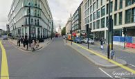
The site of Robin Hood Court is today a busy intersection. Queen Victoria Street, Cannon Street and Bow Lane cross one another here / Google Earth Street View.
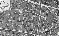
Robin Hood Court is labelled "Robinwoods C." on John Rocque's map of London and Westminster (1746) / Locating London's Past.
