
Robin Hood Close (Outwood)
| Locality | |
|---|---|
| Coordinate | 53.7069, -1.52 |
| Adm. div. | West Riding of Yorkshire |
| Vicinity | W side of Potovens Lane, N and S of A650, slightly N of Wrenthorpe |
| Type | Area |
| Interest | Robin Hood name |
| Status | Defunct |
| First Record | 1845) |
| A.k.a. | Robinhood Close |


By Henrik Thiil Nielsen, 2020-08-22. Revised by Henrik Thiil Nielsen, 2021-02-14.
Robin Hood Close is listed in the tithe award for Stanley cum Wrenthorpe (1845). It was situated on the west side of Potovens Lane, a street crossing Robin Hood's Hill in an area about equidistant from Wrenthorpe, Carr Gate and Outwood. the close covered an area which now includes the residential streets of Mount Avenue and South Park Way.
At Robin Hood Hill, Potovens Lane was previously known as Robin Hood Hill Lane. On the east side of the lane, on and along Robin Hood Hill, i.e. opposite Robin Hood Close, was formerly found Robin Hood House, while at the north end of the hill, Robin Hood Bridge still takes Potovens Lane over the line of the former West Yorkshire Railway, which is now the Doncaster and Leeds Line. In 1790-91, a couple of generations before the railway came, several fields on the east side of the lane were named after Robin Hood or were still remembered to have been so: Lower Robin Hood Close (Outwood) (1), Lower Robin Hood Close (Outwood) (2), Robin Hood Far Stile Close (Outwood), Robin Hood Near Stile Close (Outwood) and Upper Robin Hood Close (Outwood). Further back, in the mid-17th century, we find Robin Hood Street Close (Outwood). None of these closes on the east side of Potovens Lane can be pinpointed on the map, but they all lay on land belonging to the Manor of Wakefield, and as no tithes had to be paid for them, they do not appear in the tithe award for Stanley and Wrenthorpe, which was drawn up in 1845. This tells us that the Robin Hood Close which forms the subject of this page should not be identified with one or more of them, for it was one of the plots for which tithes had to be paid.
The tithe award includes three contiguous plots, all occupied by a John Marshland:
- Robin Hood Close, owned by the Vicar of Wakefield, state of cultivation: Pasture; area: 3 acres, 3 roods and 37 perches (16111.55 m2)
- Robin Hood Close, owned by the Vicar of Wakefield, state of cultivation: Meadow; area: 1 acre and 6 perches (4198.61 m2)
- Robinhood Close, owned by Edward Hemingway, state of cultivation: Arable; area: 3 acre, 3 roods and 29 perches (15909.2 m2).[1]
Gazetteers
- Dobson, R. B., ed.; Taylor, J., ed. Rymes of Robyn Hood: an Introduction to the English Outlaw (London, 1976), p. 309, s.n. "Robin Hood Hill".
MS sources
- 1845 tithe award for Stanley cum Wrenthorpe, online at the Genealogist, piece 43, sub-piece 374, image 025 (items #146 and #160), image 041 (item #147) (£)
- accompanying map, online at the Genealogist, piece 43, sub-piece 374, sub-image 001 (£).
Maps
- 25" O,S, map Yorkshire CCXXXIII.14 (c. 1894; surveyed c. 1892). No copy in NLS.
- 25" O.S. map Yorkshire CCXXXIII.14 (1907; rev. 1905) (georeferenced)
- 25" O.S. map Yorkshire CCXXXIII.14 (1907; rev. 1905)
- 25" O.S. map Yorkshire CCXXXIII.14 (1914; rev. 1913)
- 25" O.S. map Yorkshire CCXXXIII.14 (1942; rev. 1939)
- 6" O.S. map Yorkshire 233 (1854; surveyed 1848–51)
- 6" O.S. map Yorkshire CCXXXIII.SW (1894; surveyed 1892)
- 6" O.S. map Yorkshire CCXXXIII.SW (1908; rev. 1906) (georeferenced)
- 6" O.S. map Yorkshire CCXXXIII.SW (1908; rev. 1906)
- 6" O.S. map Yorkshire CCXXXIII.SW (1931; rev. 1931–32)
- 6" O.S. map Yorkshire CCXXXIII.SW (1947; rev. 1939)
- 6" O.S. map Yorkshire CCXXXIII.SW (1949; rev. 1948).
Also see
Notes
- ↑ 1845 tithe award for Stanley cum Wrenthorpe, online at the Genealogist, piece 43, sub-piece 374, image 025 (items #146 and #160), image 041 (item #147) (£); accompanying map, online at the Genealogist, piece 43, sub-piece 374, sub-image 001 (£).
Image gallery
Click any image to display it in the lightbox, where you can navigate between images by clicking in the right or left side of the current image.
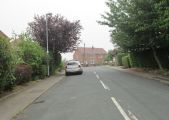
Mount Avenue; this area was once part of Robin Hood Close / Betty Longbottom, 22 July 2013, Creative Commons, via Geograph.
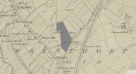
Approximate indication in dark gray of the area formerly known as Robin Hood Close / 6" O.S. map Yorkshire 233 (1854; surveyed 1848–51) – Reproduced with the permission of the National Library of Scotland.