Robin Hood Bridge (Outwood): Difference between revisions
m (Text replacement - " === Notes ===" to " === Notes ===") |
m (Text replacement - "Category:Place-Names-topics" to "Category:Place-names-topics") |
||
| Line 49: | Line 49: | ||
{{#ask: [[Category:English place-names]][[Utitle::<<{{#replace:{{uc:{{PAGENAME}}}}|'|'}}]]|order=descending|searchlabel=|format=template|introtemplate=BeforeNav|template=Nav|outrotemplate=Previous|link=none|limit=1|sort=Utitle}}[[Place-names]]{{#ask: [[Category:English place-names]][[Utitle::>>{{#replace:{{uc:{{PAGENAME}}}}|'|'}}]]|order=ascending|searchlabel=|format=template|introtemplate=BeforeNav|template=Nav|outrotemplate=Next|link=none|limit=1|sort=Utitle}}</div></div> | {{#ask: [[Category:English place-names]][[Utitle::<<{{#replace:{{uc:{{PAGENAME}}}}|'|'}}]]|order=descending|searchlabel=|format=template|introtemplate=BeforeNav|template=Nav|outrotemplate=Previous|link=none|limit=1|sort=Utitle}}[[Place-names]]{{#ask: [[Category:English place-names]][[Utitle::>>{{#replace:{{uc:{{PAGENAME}}}}|'|'}}]]|order=ascending|searchlabel=|format=template|introtemplate=BeforeNav|template=Nav|outrotemplate=Next|link=none|limit=1|sort=Utitle}}</div></div> | ||
[[Category:West Riding of Yorkshire place-names]] | [[Category:West Riding of Yorkshire place-names]] | ||
[[Category:Place- | [[Category:Place-names-topics]] | ||
[[Category:Outwood place-name cluster]] | [[Category:Outwood place-name cluster]] | ||
[[Category:Places named Robin Hood Bridge]] | [[Category:Places named Robin Hood Bridge]] | ||
Revision as of 17:37, 2 June 2017
| Locality | |
|---|---|
| Coordinates | 53.7098, -1.514 |
| Adm. div. | West Riding of Yorkshire |
| Vicinity | W of Outwood |
| Type | Thoroughfare |
| Interest | Robin Hood name |
| Status | Extant? |
| First Record | 1894 |
By Henrik Thiil Nielsen, 2013-08-04. Revised by Henrik Thiil Nielsen, 2017-06-02.
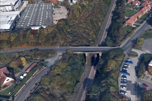
Dobson & Taylor note that "there are a Robin Hood House and a Robin Hood Bridge in the vicinity" of Robin Hood Hill, west of Outwood.[1] All three localities are indicated on the 1894 O.S. 6" map of the area.[2] While the name Robin Hood Bridge is still in use, I have no recent evidence for the House and Hill. Robin Hood Bridge is the name of the bridge that takes Potovens Lane over the Doncaster and Leeds Line (formerly the West Yorkshire Railway). The bridge is not found on the 1854 O.S. 6" map of the area and so evidently was built sometime during the next 40 years.
Gazetteers
- Dobson, R. B., ed.; Taylor, J., ed. Rymes of Robyn Hood: an Introduction to the English Outlaw (London, 1976), p. 309, s.n. "Robin Hood Hill".
Sources
Maps
- O.S. 6" map Yorkshire 233 (1854, surveyed 1848-51)
- O.S. 6" map Sheet CCXXXIII.SW (1894); Robin Hood Bridge, Hill and House to the far right.
- O.S. 6" map Yorkshire 233 (1908, rev. 1906)
- O.S. 6" map Yorkshire 233 (1932, rev. 1931-32)
- O.S. 6" map Yorkshire 233 (1947, rev. 1939)
- O.S. 6" map Yorkshire 233 (1949, rev. 1948).
Also see
Notes
- ↑ Dobson, R. B., ed.; Taylor, J., ed. Rymes of Robyn Hood: an Introduction to the English Outlaw (London, 1976), p. 309, s.n. "Robin Hood Hill".
- ↑ O.S. 6" map Sheet CCXXXIII.SW (1894).; Robin Hood Bridge, Hill and House to the right.
Template:BeforeNavTemplate:NavTemplate:PreviousWest Riding of Yorkshire place-namesTemplate:BeforeNavTemplate:NavTemplate:Next
Template:BeforeNavTemplate:NavTemplate:PreviousYorkshire place-namesTemplate:BeforeNavTemplate:NavTemplate:Next
Template:BeforeNavTemplate:NavTemplate:PreviousPlace-namesTemplate:BeforeNavTemplate:NavTemplate:Next"th" can not be assigned to a declared number type with value 19.

