
Robin Hood (Willenhall): Difference between revisions
From International Robin Hood Bibliography
m (Text replacement - "PlaceNamesItemQuery" to "PlaceNamesItemAllusionsAndRecords") |
m (Text replacement - "ImgGalleryIntro" to "ImageGalleryIntroduction") |
||
| Line 14: | Line 14: | ||
<div id="gallery"> | <div id="gallery"> | ||
{{ | {{ImageGalleryIntroduction}} | ||
<gallery widths="195px"> | <gallery widths="195px"> | ||
File:Robin Hood (The Crescent, Willenhall, Staffordshire).jpg|The Robin Hood / [http://www.geograph.org.uk/profile/20846 P.L. Chadwick, 29 Dec. 2011, Creative Commons, via Geograph.] | File:Robin Hood (The Crescent, Willenhall, Staffordshire).jpg|The Robin Hood / [http://www.geograph.org.uk/profile/20846 P.L. Chadwick, 29 Dec. 2011, Creative Commons, via Geograph.] | ||
Latest revision as of 13:53, 7 January 2021
| Locality | |
|---|---|
| Coordinate | 52.583504, -2.039628 |
| Adm. div. | Staffordshire |
| Vicinity | 5 The Crescent, Willenhall |
| Type | Public house |
| Interest | Robin Hood name |
| Status | Extant |
| First Record | |
The Robin Hood.
.jpg)
The Robin Hood / P.L. Chadwick, 29 Dec. 2011, Creative Commons, via Geogragh.
By Henrik Thiil Nielsen, 2013-08-07. Revised by Henrik Thiil Nielsen, 2021-01-07.
A pub which acquired a new sign and changed its affiliation sometime between April 13, 2009 and Dec. 29, 2011.
Gazetteers
Also see
Image gallery
Click any image to display it in the lightbox, where you can navigate between images by clicking in the right or left side of the current image.
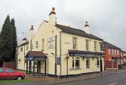
The Robin Hood / P.L. Chadwick, 29 Dec. 2011, Creative Commons, via Geograph.
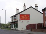
The Robin Hood / Gordon Griffiths, 23 Apr. 2009, Creative Commons, via Geograph.
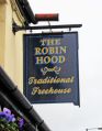
The Robin Hood / P.L. Chadwick, 29 Dec. 2011, Creative Commons, via Geograph.
_2009.jpg)
_sign.jpg)