
Robin Hood (Upminster): Difference between revisions
From International Robin Hood Bibliography
m (Text replacement - " <p id="byline">" to "<div class="no-img"><p id="byline">") |
m (Text replacement - ".</p><div class="no-img">" to ".</p>") |
||
| Line 2: | Line 2: | ||
Status=Defunct|Demonym=English|Riding=|GreaterLondon=Yes|Year=1842|Aka=|Century=19|Cluster1=Hacton|Cluster2=|Cluster3=|Image=robin-hood-upminster-google-earth-street-view-2.jpg|Postcards=|ExtraCat1=Places named Robin Hood's Close|ExtraCat2=|ExtraCat3=|ExtraCat4=|ExtraCat5=|ExtraLink1=|ExtraLink2=|ExtraLink3=|ExtraLink4=|ExtraLink5=|ExtraLinkName1=|ExtraLinkName2=|ExtraLinkName3=|ExtraLinkName4=|ExtraLinkName5=|GeopointPrefix=|GeopointSuffix=|VicinitySuffix=|StatusSuffix=?|DatePrefix=|DateSuffix=}} | Status=Defunct|Demonym=English|Riding=|GreaterLondon=Yes|Year=1842|Aka=|Century=19|Cluster1=Hacton|Cluster2=|Cluster3=|Image=robin-hood-upminster-google-earth-street-view-2.jpg|Postcards=|ExtraCat1=Places named Robin Hood's Close|ExtraCat2=|ExtraCat3=|ExtraCat4=|ExtraCat5=|ExtraLink1=|ExtraLink2=|ExtraLink3=|ExtraLink4=|ExtraLink5=|ExtraLinkName1=|ExtraLinkName2=|ExtraLinkName3=|ExtraLinkName4=|ExtraLinkName5=|GeopointPrefix=|GeopointSuffix=|VicinitySuffix=|StatusSuffix=?|DatePrefix=|DateSuffix=}} | ||
{{#display_map:{{#var:Coords}}~{{#replace:{{PAGENAME}}|'|'}}|width=34%|service=leaflet|enablefullscreen=yes}}<div class="pnMapLegend">{{PAGENAME}}.</div> | {{#display_map:{{#var:Coords}}~{{#replace:{{PAGENAME}}|'|'}}|width=34%|service=leaflet|enablefullscreen=yes}}<div class="pnMapLegend">{{PAGENAME}}.</div> | ||
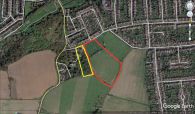
[[File:robin-hood-upminster-google-earth-street-view.jpg|thumb|right|500px|Robin Hood (red outline) and its smaller neighbour, [[Little John's Mead (Upminster)|Little John's Mead]] (yellow outline) / Google Earth Street View.]]<div class="no-img"><p id="byline">By Henrik Thiil Nielsen, 2018-02-19. Revised by {{#realname:{{REVISIONUSER}}}}, {{REVISIONYEAR}}-{{REVISIONMONTH}}-{{REVISIONDAY2}}.</p | [[File:robin-hood-upminster-google-earth-street-view.jpg|thumb|right|500px|Robin Hood (red outline) and its smaller neighbour, [[Little John's Mead (Upminster)|Little John's Mead]] (yellow outline) / Google Earth Street View.]]<div class="no-img"><p id="byline">By Henrik Thiil Nielsen, 2018-02-19. Revised by {{#realname:{{REVISIONUSER}}}}, {{REVISIONYEAR}}-{{REVISIONMONTH}}-{{REVISIONDAY2}}.</p> | ||
The 1842 tithe award for Upminster lists 'Robin Hood' as the name of a close on the southeast side of Little Gaynes Lane in Hacton, Upminster. Its owner is listed as Thomas Agar, occupier as Henry Jostin, area as 9 acres, 3 roods and 6 perches ({{AcreRoodPerchToM2|9|3|6}} m<sup>2</sup>).<ref>Tithe award for Upminster, online at the [https://www.thegenealogist.com Genealogist], Piece 12, Sub-Piece 356, Image 006 (subscription required); [https://www.thegenealogist.com Genealogist], Piece 12, Sub-Piece 356, Sub-Image 001; map (subscription required). {{:Waller, William Chapman 1898a}}; see pp. 62, 79.</ref> Immediately west of Robin Hood was [[Little John's Mead (Upminster)|Little John's Mead]].{{PnItemQry}} | The 1842 tithe award for Upminster lists 'Robin Hood' as the name of a close on the southeast side of Little Gaynes Lane in Hacton, Upminster. Its owner is listed as Thomas Agar, occupier as Henry Jostin, area as 9 acres, 3 roods and 6 perches ({{AcreRoodPerchToM2|9|3|6}} m<sup>2</sup>).<ref>Tithe award for Upminster, online at the [https://www.thegenealogist.com Genealogist], Piece 12, Sub-Piece 356, Image 006 (subscription required); [https://www.thegenealogist.com Genealogist], Piece 12, Sub-Piece 356, Sub-Image 001; map (subscription required). {{:Waller, William Chapman 1898a}}; see pp. 62, 79.</ref> Immediately west of Robin Hood was [[Little John's Mead (Upminster)|Little John's Mead]].{{PnItemQry}} | ||
== Gazetteers == | == Gazetteers == | ||
Revision as of 04:16, 17 May 2020
Robin Hood (Upminster).

Robin Hood (red outline) and its smaller neighbour, Little John's Mead (yellow outline) / Google Earth Street View.
By Henrik Thiil Nielsen, 2018-02-19. Revised by Henrik Thiil Nielsen, 2020-05-17.
The 1842 tithe award for Upminster lists 'Robin Hood' as the name of a close on the southeast side of Little Gaynes Lane in Hacton, Upminster. Its owner is listed as Thomas Agar, occupier as Henry Jostin, area as 9 acres, 3 roods and 6 perches (Template:AcreRoodPerchToM2 m2).[1] Immediately west of Robin Hood was Little John's Mead.Template:PnItemQry
Gazetteers
- Not included in Dobson, R. B., ed.; Taylor, J., ed. Rymes of Robyn Hood: an Introduction to the English Outlaw (London, 1976), pp. 293-311.
MS sources
- Tithe award for Upminster, online at the Genealogist, Piece 12, Sub-Piece 356, Image 006 (subscription required)
- Accompanying map, online at the Genealogist, Piece 12, Sub-Piece 356, Sub-Image 001 (subscription required).
Printed sources
Maps
'Robin Hood' not labelled.
- 25" O.S. map Essex LXXV.5 (1897; rev. 1895)
- 25" O.S. map Essex LXXV.5 (1897; rev. 1895) (georeferenced)
- 6" O.S. map Essex LXXV.NW (1898; rev. 1895)
- 6" O.S. map Essex LXXV.NW (1898; rev. 1895) (georeferenced)
- 6" O.S. map Essex nLXXXVII.NE (1921; rev. 1915)
- 6" O.S. map Essex nLXXXVII.NE (c. 1945; rev. 1938)
- 1:25,000 O.S. map TQ58 (1959; surveyed 1938-55) (georeferenced)
- 1:1 million–1:10k (1900s) (georeferenced).
Background
Notes
- ↑ Tithe award for Upminster, online at the Genealogist, Piece 12, Sub-Piece 356, Image 006 (subscription required); Genealogist, Piece 12, Sub-Piece 356, Sub-Image 001; map (subscription required). Waller, William Chapman, compil. 'Essex Field Names: Part II.—The Hundreds of Beacontree, Chafford, and Barstable, with the Liberty of Havering', Transactions of the Essex Archæological Society, New Series, vol. VI (1898), pp. 60-84; see pp. 62, 79.
Robin Hood (red outline) and its smaller neighbour, Little John's Mead (yellow outline) / Google Earth Street View.
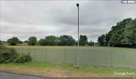
Looking SE at the NW end of Robin Hood from Little Gaynes Lane.
