
Robin Hood (Stretford, Manchester) (2): Difference between revisions
mNo edit summary |
mNo edit summary |
||
| Line 1: | Line 1: | ||
__NOTOC__{{PnItemTop|Lat=53.445478|Lon=-2.314112|AdmDiv=Lancashire|Vicinity=125 Barton Road, Stretford, Manchester|Type=Public house|Interest=Robin Hood name|Status=Extant|Demonym=|Riding=|GreaterLondon=|Year=1903|Aka=|Century=|Cluster1=Stretford, Manchester|Cluster2=|Cluster3=|Image=robin-hood-stretford-manchester-google-earth-street-view-1.jpg|Postcards=|ExtraCat1=|ExtraCat2=|ExtraCat3=|ExtraCat4=|ExtraCat5=|ExtraLink1=Robin Hood (Stretford, Manchester) (1)|ExtraLink2=|ExtraLink3=|ExtraLink4=|ExtraLink5=|ExtraLinkName1=|ExtraLinkName2=|ExtraLinkName3=|ExtraLinkName4=|ExtraLinkName5=|GeopointPrefix=|GeopointSuffix=|StatusSuffix=|DatePrefix=|DateSuffix=}} | __NOTOC__{{PnItemTop|Lat=53.445478|Lon=-2.314112|AdmDiv=Lancashire|Vicinity=125 Barton Road, Stretford, Manchester|Type=Public house|Interest=Robin Hood name|Status=Extant|Demonym=|Riding=|GreaterLondon=|Year=1903|Aka=|Century=|Cluster1=Stretford, Manchester|Cluster2=Manchester|Cluster3=|Image=robin-hood-stretford-manchester-google-earth-street-view-1.jpg|Postcards=|ExtraCat1=|ExtraCat2=|ExtraCat3=|ExtraCat4=|ExtraCat5=|ExtraLink1=Robin Hood (Stretford, Manchester) (1)|ExtraLink2=|ExtraLink3=|ExtraLink4=|ExtraLink5=|ExtraLinkName1=|ExtraLinkName2=|ExtraLinkName3=|ExtraLinkName4=|ExtraLinkName5=|GeopointPrefix=|GeopointSuffix=|StatusSuffix=|DatePrefix=|DateSuffix=}} | ||
{{#display_map:{{#var:Coords}}~{{#replace:{{PAGENAME}}|'|'}}|width=34%}}<div class="pnMapLegend">The Robin Hood.</div> | {{#display_map:{{#var:Coords}}~{{#replace:{{PAGENAME}}|'|'}}|width=34%}}<div class="pnMapLegend">The Robin Hood.</div> | ||
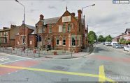
[[File:{{#var:Pnimage}}|thumb|right|500px|The Robin Hood, looking south on Urmston Lane / Google Earth Street View.]] | [[File:{{#var:Pnimage}}|thumb|right|500px|The Robin Hood, looking south on Urmston Lane / Google Earth Street View.]] | ||
Revision as of 19:54, 27 February 2019
[[File:|thumb|right|500px|The Robin Hood, looking south on Urmston Lane / Google Earth Street View.]]
By Henrik Thiil Nielsen, 2013-08-07. Revised by Henrik Thiil Nielsen, 2019-02-27.
There is a pub named the Robin Hood at 125 Barton Road, the corner of Urmston Lane/Barton Road, in Stretford, Manchester.
Evidently the inn only became the Robin Hood at some point in the 19th century, for H. T. Crofton noted in 1903 that "[t]he Robin Hood Inn is the modern name for the old Waggon and Horses, and stood on the west side of Butt Lane, which leads from King Street or Urmston Lane towards Derbyshire Lane".[1] If, as this suggests, the inn was originally located north of King Street/Urmston Lane, it must at some point have moved a little south, for its present premises are on the south side of Kingsway/Urmston Lane. A citizen born c. 1816 remembered that "[i]n the roadway at Four Lane Ends, opposite the Waggon and Horses, which was afterwards the Robin Hood, there was an iron ring fixed for bear baiting".[2] One 19th century keeper after the pub had become the Robin Hood was named John Hamer[3] Slater's Directory for 1845 lists Josiah Johnson Smith, victualler", as keeper of the Robin Hood.[4]In keeping with O.S. practice for built-up areas, the maps listed below include the indication "P.H." but do not include the name of the pub.Template:PnItemQry
Gazetteers
- Not included in Dobson, R. B., ed.; Taylor, J., ed. Rymes of Robyn Hood: an Introduction to the English Outlaw (London, 1976), pp. 293-11.
Sources
- Crofton, H. T. A History of the Ancient Chapel of Stretford in Manchester Parish, including Sketches of the Township of Stretford together with Notices of Local Families and Persons (Remains Historical and Literary connected with the Palatine Counties of Lancaster and Cheshire, New series, vols. 42, 45 and 51) (Manchester, 1899-1903), vol. III (1903), pp. 10, 11, 14, 24, 216, 218.
Maps
- 6" O.S. map Lancashire CX (1848; surveyed 1845)
- 6" O.S. map Lancashire CX.NE (1910; rev. 1904) (georeferenced)
- 6" O.S. map Lancashire CX.NE (1910; rev. 1904)
- 6" O.S. map Lancashire CX.NE (1929; rev. 1926-27)
- 6" O.S. map Lancashire CX.NE (1947; rev. 1938)
- 25" O.S. map Lancashire CX.4 (1907; rev. 1904) (georeferenced)
- 25" O.S. map Lancashire CX.4 (1907; rev. 1904)
- 25" O.S. map Lancashire CX.4 (1928; rev. 1927)
- 25" O.S. map Lancashire CX.4 (1939; rev. 1937-38).
Drawings
- "Mr. John Owen in the 40th volume of his interesting manuscripts, which are in the Manchester Free Library, has made drawings of the following Stretford buildings, copies of some of which illustrate this volume [... including] Robin Hood Inn, kept by John Hamer, at the corner of Urmston Lane", cf. Crofton, H. T. A History of the Ancient Chapel of Stretford in Manchester Parish, including Sketches of the Township of Stretford together with Notices of Local Families and Persons (Remains Historical and Literary connected with the Palatine Counties of Lancaster and Cheshire, New series, vols. 42, 45 and 51) (Manchester, 1899-1903), vol. III (1903), p. 24.
Notes
- ↑ Crofton, H. T. A History of the Ancient Chapel of Stretford in Manchester Parish, including Sketches of the Township of Stretford together with Notices of Local Families and Persons (Remains Historical and Literary connected with the Palatine Counties of Lancaster and Cheshire, New series, vols. 42, 45 and 51) (Manchester, 1899-1903), vol. III (1903), p. 10.
- ↑ Crofton, H. T. A History of the Ancient Chapel of Stretford in Manchester Parish, including Sketches of the Township of Stretford together with Notices of Local Families and Persons (Remains Historical and Literary connected with the Palatine Counties of Lancaster and Cheshire, New series, vols. 42, 45 and 51) (Manchester, 1899-1903), vol. III (1903), p. 11, and see p. 14.
- ↑ See Drawings below.
- ↑ Crofton, H. T. A History of the Ancient Chapel of Stretford in Manchester Parish, including Sketches of the Township of Stretford together with Notices of Local Families and Persons (Remains Historical and Literary connected with the Palatine Counties of Lancaster and Cheshire, New series, vols. 42, 45 and 51) (Manchester, 1899-1903), vol. III, pp. 216, 218.

The Robin Hood, looking south on Urmston Lane / Google Earth Street View.
The Robin Hood, looking west on Urmston Lane / Google Earth Street View.

