
Robin Hood (Standford): Difference between revisions
From International Robin Hood Bibliography
m (Text replacement - "AdmDiv" to "AdministrativeDivision") |
m (Text replacement - "PnItemTop" to "PlaceNamesItemTop") |
||
| Line 1: | Line 1: | ||
__NOTOC__{{ | __NOTOC__{{PlaceNamesItemTop|Lat=51.105577|Lon=-0.835826|AdministrativeDivision=Hampshire|Vicinity=Standford Lane, Standford, Bordon|Type=Public house|Interest=Robin Hood name|Status=Defunct|Demonym=|Riding=|GreaterLondon=|Year=1881|Aka=|Century=|Cluster1=|Cluster2=|Cluster3=|Image=robin_hood_public_house_geograph.jpg|Postcards=|ExtraCat1=|ExtraCat2=|ExtraCat3=|ExtraCat4=|ExtraCat5=|ExtraLink1=|ExtraLink2=|ExtraLink3=|ExtraLink4=|ExtraLink5=|ExtraLinkName1=|ExtraLinkName2=|ExtraLinkName3=|ExtraLinkName4=|ExtraLinkName5=|GeopointPrefix=|GeopointSuffix=|StatusSuffix=|DatePrefix=|DateSuffix=}} | ||
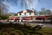
{{#display_map:{{#var:Coords}}~{{#replace:{{PAGENAME}}|'|'}}|width=34%|enablefullscreen=yes}}<div class="pnMapLegend">The Robin Hood, now Whiteleys Family Restaurant.</div> | {{#display_map:{{#var:Coords}}~{{#replace:{{PAGENAME}}|'|'}}|width=34%|enablefullscreen=yes}}<div class="pnMapLegend">The Robin Hood, now Whiteleys Family Restaurant.</div> | ||
[[File:{{#var:Image}}|500px|thumb|right|The Robin Hood, Standford Lane / [http://www.geograph.org.uk/profile/28338 Shazz] Nov. 25, 2008, Creative Commons via | [[File:{{#var:Image}}|500px|thumb|right|The Robin Hood, Standford Lane / [http://www.geograph.org.uk/profile/28338 Shazz] Nov. 25, 2008, Creative Commons via | ||
Revision as of 23:58, 5 January 2021
| Locality | |
|---|---|
| Coordinate | 51.105577, -0.835826 |
| Adm. div. | Hampshire |
| Vicinity | Standford Lane, Standford, Bordon |
| Type | Public house |
| Interest | Robin Hood name |
| Status | Defunct |
| First Record | 1881 |
The Robin Hood, now Whiteleys Family Restaurant.

The Robin Hood, Standford Lane / Shazz Nov. 25, 2008, Creative Commons via Geograph.
By Henrik Thiil Nielsen, 2013-07-28. Revised by Henrik Thiil Nielsen, 2021-01-05.
The former Robin Hood in Standford is now Whiteleys Family Restaurant. Information on publicans for the years 1881-1927 can be found at UK Pub History.[1]Template:PnItemQry
Gazetteers
- Not included in Dobson, R. B., ed.; Taylor, J., ed. Rymes of Robyn Hood: an Introduction to the English Outlaw (London, 1976), pp. 293-311.
Sources
Map
- 25" O.S. map Hampshire and Isle of Wight XLIV.3 (c. 1872; surveyed 1868-69). No Copy in NLS
- 25" O.S. map Hampshire and Isle of Wight XLIV.3 (c. 1897; rev. c. 1895). No Copy in NLS
- 25" O.S. map Hampshire and Isle of Wight XLIV.3 (1910; rev. 1909) (georeferenced)
- 25" O.S. map Hampshire and Isle of Wight XLIV.3 (1910; rev. 1909)
- 6" O.S. map Hampshire & Isle of Wight XLIV (1872; surveyed 1869-70)
- 6" O.S. map Hampshire & Isle of Wight XLIV.NE (1898; rev. 1895)
- 6" O.S. map Surrey XLIV.NW & NE (1899; rev. 1895) (georeferenced)
- 6" O.S. map Hampshire & Isle of Wight XLIV.NE (1910; rev. 1909).
Notes
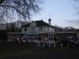
Now: whiteley's, Standford Lane / proprietors via Google Earth.
Whiteley's Family Restaurant, formerly the Robin Hood pub, in Standford / Shazz, 25 Nov. 2008, Creative Commons, via Geograph.
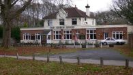
The Robin Hood, Standford Lane / David960, 29 Dec. 2013, Creative Commons, via Geograph.

