
Robin Hood (St Giles)
[[File:|thumb|right|500px|Bucknall Street, St Giles, near which the Robin Hood was located / Google Earth Street View.]]


By Henrik Thiil Nielsen, 2018-06-20. Revised by Henrik Thiil Nielsen, 2019-05-31.
The Robin Hood at 24 Church Lane (or 26 Church Street), St Giles, existed by 1750 and at least as late as 1858. Pigot's Directory of London (1839) lists the address as "26 Church Street, St Giles", while Robsons Public House & Publican Directory (1842) has "24 Church lane, Bloomsbury".[1] Rather than the pub moving, this is in all probability due to a change in nomenclature and street layout.
Both streets are included on John Rocque's 1746 map of London and Westminster (shown on this page). Church Street ran parallel to Bainbridge Street in a west-south-westerly direction from Dyot Street until about three-fifths the distance to St Giles High Street – in modern terms probably a point somewhere inside the Zizzi pizza restaurant on Bucknall Street – at which point it became Church Lane, continuing in a west-north-westerly direction, subsequently turning NNW and continuing on until it met Bainbridge Street. On Richard Horwood's Plan of the Cities of London and Westminster (1792-99) both street layout and nomenclature have changed, but essentially Church lane has become Church Street and vice versa.[2] Some time before 1875 (see 25" O.S. map listed below) a street named Arthur Street (more or less the modern Earnshaw Street) had been constructed, swallowing up the northernmost half of Church Lane, and on the 1875 map the remainder of Church Lane and the entire length of Church Street are now labelled 'Church Lane'. By 1914 when the map was revised, this Church Lane had in turn been renamed Bucknall Street. However, from the splendid version of John Rocque's map at the Locating London's Past site, 'deformed' to match modern satellite imagery and maps, one gets the impression that the original Church Street ran a few meters south of the modern Bucknall Street. In all events it seems likely that the difference in address between the 1839 and 1842 directories reflects the change in nomenclature.
With this changing street layout and often vague and sometimes conflicting nomenclature I do not feel I am able to say with certainty where the Robin Hood was located. However, there were in London a handful of Robin Hood's courts or yards adjacent to, or in the immediate vicinity of, pubs also named after the outlaw, and as there was a Robin Hood Court at the eastern end of Church Lane/Street, near Dyott Street, it is likely the Robin Hood was in its immediate vicinity. The cordinates I have used in the info box and on the Google map assume that the Robin Hood was located between the then Church lane (≈Bucknall Street) and the court. This spot is now occupied by the building with the orange front in Bucknall Street (see google Map Street View photo below). It seems certain, at least, that the pub and court would have been within what is now known as Central Saint Giles Piazza.
According to the "patrol" cited in the first of the records from 1822 cited below, the Robin Hood was "a resort for thieves".Template:PnItemQry
Gazetteers
- Not included in Dobson, R. B., ed.; Taylor, J., ed. Rymes of Robyn Hood: an Introduction to the English Outlaw (London, 1976), pp. 293-311.
Sources
Maps
- Rocque, John, cartog.; Pine, John, engr. A Plan of the Cities of London and Westminster, and Borough of Southwark (London, 1746)
- 25" O.S. map London (First Editions c1850s) XXXIV (1875; surveyed 1870)
- 25" O.S. map London (1915- Numbered sheets) V.9 (1934; rev. 1914)
- 25" O.S. map London (1915- Numbered sheets) V.9 (1934; rev. 1914) (georeferenced)
- 6" O.S. map Middlesex XVII (1880-82; surveyed 1868-73)
- 6" O.S. map Surrey III (1880; surveyed 1868-73)
- 6" O.S. map London VII.SW (1894-96; rev. 1893-95)
- 6" O.S. map Surrey III.NW (1898; rev. 1893-95)
- 6" O.S. map Surrey III.NW (1898; rev. 1893-95) (georeferenced)
- 6" O.S. map London Sheet K (1920; rev. 1913-14)
- 6" O.S. map London Sheet K (c. 1946; rev. 1938).
Background
Notes
- ↑ UK Pub History: The London 1839 Public House & Publican Directory - as listed in LONDON 1839 Pigots Directory - R3; UK Pub History: The London 1842 Robsons Public House & Publican Directory - R2. Both list James Mason under the address.
- ↑ Romantic London: Horwood's Plan.
- ↑ Also see UK Pub History: The London 1839 Public House & Publican Directory - as listed in LONDON 1839 Pigots Directory - R3; UK Pub History: The London 1842 Robsons Public House & Publican Directory - R2.
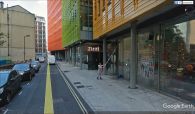
Bucknall Street, St Giles, near which the Robin Hood was located / Google Earth Street View.

The most likely site of the Robin Hood / Google Earth Street View.
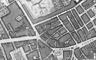
John Rocque's Plan of the Cities of London and Westminster, and Borough of Southwark (1746), centred on Church Lane and Church Street / Locating London's Past.
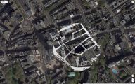
Part of street plan with Church Lane and Street from Rocque's 1746 map superimposed on satellite image / Adapted from materials at Locating London's Past.
