
Robin Hood (Southampton) (1): Difference between revisions
m (Text replacement - "ImgGalleryIntro" to "ImageGalleryIntroduction") |
m (Text replacement - "UK Pub History" to "Pub History") |
||
| (8 intermediate revisions by the same user not shown) | |||
| Line 3: | Line 3: | ||
[[File:{{#var:Image}}|thumb|right|500px| ]]<div class="no-img"> | [[File:{{#var:Image}}|thumb|right|500px| ]]<div class="no-img"> | ||
<p id="byline">By Henrik Thiil Nielsen, 2013-08-07. Revised by {{#realname:{{REVISIONUSER}}}}, {{REVISIONYEAR}}-{{REVISIONMONTH}}-{{REVISIONDAY2}}.</p> | <p id="byline">By Henrik Thiil Nielsen, 2013-08-07. Revised by {{#realname:{{REVISIONUSER}}}}, {{REVISIONYEAR}}-{{REVISIONMONTH}}-{{REVISIONDAY2}}.</p> | ||
The Robin Hood on the corner of South East Road and Middle Road near Sholing in Southampton is first recorded in 1871. | The Robin Hood on the corner of South East Road and Middle Road near Sholing in Southampton is first recorded in 1871. | ||
Pub History lists publican information for this pub for 1871–1954.<ref>[https://pubwiki.co.uk/Hampshire/Southampton/RobinHoodSholing.shtml Pub History: Robin Hood, 6 South East Road, Sholing, Southampton, Hampshire]; [https://pubwiki.co.uk/Hampshire/Hampshire1911/Hampshire1911QR.shtml Public Houses, Inns & Taverns of Hampshire in 1911 - QR.]</ref> The Robin Hood was affiliated with the local brewery of William Cooper & Co. Ltd.<ref>[http://breweryhistory.com/wiki/index.php?title=List_of_William_Cooper_%26_Co_Ltd_pubs Brewery History: List of William Cooper & Co Ltd pubs], #79; [http://breweryhistory.com/wiki/index.php?title=William_Cooper_%26_Co._Ltd Brewery History: William Cooper & Co. Ltd].</ref>{{PlaceNamesItemAllusionsAndRecords}} | |||
== Gazetteers == | == Gazetteers == | ||
| Line 9: | Line 11: | ||
== Sources == | == Sources == | ||
* [https://pubwiki.co.uk/Hampshire/Southampton/RobinHoodSholing.shtml | * [https://pubwiki.co.uk/Hampshire/Southampton/RobinHoodSholing.shtml Pub History: Robin Hood, 6 South East Road, Sholing, Southampton, Hampshire] | ||
** [https://pubwiki.co.uk/Hampshire/Hampshire1911/Hampshire1911QR.shtml Public Houses, Inns & Taverns of Hampshire in 1911 - QR.] | |||
== Background == | |||
* [http://breweryhistory.com/wiki/index.php?title=List_of_William_Cooper_%26_Co_Ltd_pubs Brewery History: List of William Cooper & Co Ltd pubs], #79 | |||
** [http://breweryhistory.com/wiki/index.php?title=William_Cooper_%26_Co._Ltd Brewery History: William Cooper & Co. Ltd]. | |||
== Maps == | == Maps == | ||
* 25" O.S. map ''Hampshire | * 25" O.S. map ''Hampshire & Isle of Wight'' LXV.12 (''c.'' 1871; surveyed 1865). No copy in NLS | ||
* [https://maps.nls.uk/geo/explore/#zoom=17&lat=50.9040&lon=-1.3614&layers=168&b=5 25" O.S. map ''Hampshire | * [https://maps.nls.uk/geo/explore/#zoom=17&lat=50.9040&lon=-1.3614&layers=168&b=5 25" O.S. map ''Hampshire & Isle of Wight'' LXV.12 (1897; rev. 1895-96)] (georeferenced) | ||
* [https://maps.nls.uk/view/105987340#zoom=4&lat=5642&lon=4749&layers=BT 25" O.S. map ''Hampshire | * [https://maps.nls.uk/view/105987340#zoom=4&lat=5642&lon=4749&layers=BT 25" O.S. map ''Hampshire & Isle of Wight'' LXV.12 (1897; rev. 1895-96)] | ||
* [https://maps.nls.uk/view/105987337#zoom=4&lat=6035&lon=5054&layers=BT 25" O.S. map ''Hampshire | * [https://maps.nls.uk/view/105987337#zoom=4&lat=6035&lon=5054&layers=BT 25" O.S. map ''Hampshire & Isle of Wight'' LXV.12 (1910; rev. 1907)] | ||
* [https://maps.nls.uk/view/105987334#zoom=4&lat=6095&lon=5127&layers=BT 25" O.S. map ''Hampshire | * [https://maps.nls.uk/view/105987334#zoom=4&lat=6095&lon=5127&layers=BT 25" O.S. map ''Hampshire & Isle of Wight'' LXV.12 (1933; rev. 1932)] | ||
* [https://maps.nls.uk/view/102343122#zoom=5&lat=4233&lon=12269&layers=BT 6" O.S. map ''Hampshire | * [https://maps.nls.uk/view/102343122#zoom=5&lat=4233&lon=12269&layers=BT 6" O.S. map ''Hampshire & Isle of Wight'' LXV (1871; surveyed 1866-69)] | ||
* [https://maps.nls.uk/geo/explore/#zoom=16&lat=50.9041&lon=-1.3614&layers=6&b=5 6" O.S. map ''Hampshire | * [https://maps.nls.uk/geo/explore/#zoom=16&lat=50.9041&lon=-1.3614&layers=6&b=5 6" O.S. map ''Hampshire & Isle of Wight'' LXV.SE (1898; rev. 1895-96)] (georeferenced) | ||
* [https://maps.nls.uk/view/101441403#zoom=4&lat=4692&lon=5435&layers=BT 6" O.S. map ''Hampshire | * [https://maps.nls.uk/view/101441403#zoom=4&lat=4692&lon=5435&layers=BT 6" O.S. map ''Hampshire & Isle of Wight'' LXV.SE (1898; rev. 1895-96)] | ||
* [https://maps.nls.uk/view/101441400#zoom=4&lat=4993&lon=5730&layers=BT 6" O.S. map ''Hampshire | * [https://maps.nls.uk/view/101441400#zoom=4&lat=4993&lon=5730&layers=BT 6" O.S. map ''Hampshire & Isle of Wight'' LXV.SE (1911; rev. 1907-1908)] | ||
* [https://maps.nls.uk/view/101441397#zoom=4&lat=5011&lon=5580&layers=BT 6" O.S. map ''Hampshire | * [https://maps.nls.uk/view/101441397#zoom=4&lat=5011&lon=5580&layers=BT 6" O.S. map ''Hampshire & Isle of Wight'' LXV.SE (''c.'' 1935; rev. 1931-32)] | ||
* [https://maps.nls.uk/view/101580259#zoom=4&lat=4914&lon=5785&layers=BT 6" O.S. map ''Hampshire | * [https://maps.nls.uk/view/101580259#zoom=4&lat=4914&lon=5785&layers=BT 6" O.S. map ''Hampshire & Isle of Wight'' LXV.SE (''c.'' 1943; rev. 1938)] | ||
* [https://maps.nls.uk/view/101441394#zoom=4&lat=4809&lon=5605&layers=BT 6" O.S. map ''Hampshire | * [https://maps.nls.uk/view/101441394#zoom=4&lat=4809&lon=5605&layers=BT 6" O.S. map ''Hampshire & Isle of Wight'' LXV.SE (''c.'' 1945; rev. 1938).] | ||
== Background == | == Background == | ||
Latest revision as of 15:31, 5 May 2022
| Locality | |
|---|---|
| Coordinate | 50.904082, -1.359478 |
| Adm. div. | Hampshire |
| Vicinity | 20 South East Road |
| Type | Public house |
| Interest | Robin Hood name |
| Status | Extant |
| First Record | 1871 |

By Henrik Thiil Nielsen, 2013-08-07. Revised by Henrik Thiil Nielsen, 2022-05-05.
The Robin Hood on the corner of South East Road and Middle Road near Sholing in Southampton is first recorded in 1871.
Pub History lists publican information for this pub for 1871–1954.[1] The Robin Hood was affiliated with the local brewery of William Cooper & Co. Ltd.[2]
Gazetteers
- Not included in Dobson, R. B., ed.; Taylor, J., ed. Rymes of Robyn Hood: an Introduction to the English Outlaw (London, 1976), pp. 293-311.
Sources
Background
Maps
- 25" O.S. map Hampshire & Isle of Wight LXV.12 (c. 1871; surveyed 1865). No copy in NLS
- 25" O.S. map Hampshire & Isle of Wight LXV.12 (1897; rev. 1895-96) (georeferenced)
- 25" O.S. map Hampshire & Isle of Wight LXV.12 (1897; rev. 1895-96)
- 25" O.S. map Hampshire & Isle of Wight LXV.12 (1910; rev. 1907)
- 25" O.S. map Hampshire & Isle of Wight LXV.12 (1933; rev. 1932)
- 6" O.S. map Hampshire & Isle of Wight LXV (1871; surveyed 1866-69)
- 6" O.S. map Hampshire & Isle of Wight LXV.SE (1898; rev. 1895-96) (georeferenced)
- 6" O.S. map Hampshire & Isle of Wight LXV.SE (1898; rev. 1895-96)
- 6" O.S. map Hampshire & Isle of Wight LXV.SE (1911; rev. 1907-1908)
- 6" O.S. map Hampshire & Isle of Wight LXV.SE (c. 1935; rev. 1931-32)
- 6" O.S. map Hampshire & Isle of Wight LXV.SE (c. 1943; rev. 1938)
- 6" O.S. map Hampshire & Isle of Wight LXV.SE (c. 1945; rev. 1938).
Background
- The Robin Hood, Sholing, Southampton (the pub's website).
Also see
Notes
Image gallery
Click any image to display it in the lightbox, where you can navigate between images by clicking in the right or left side of the current image.
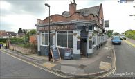
The Robin Hood seen from Middle Road / Google Earth Street View.
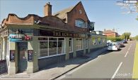
The Robin Hood seen from South East Road / Google Earth Street View.
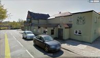
The Robin Hood seen from South East Road / Google Earth Street View.
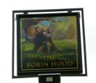
Signs of the Robin Hood / Shazz, 1 Mar. 2013, Creative Commons, via Geograph.


