
Robin Hood (Southampton) (1): Difference between revisions
From International Robin Hood Bibliography
mNo edit summary |
mNo edit summary |
||
| Line 1: | Line 1: | ||
__NOTOC__{{PnItemTop|Lat=50.904082|Lon=-1.359478|AdmDiv=Hampshire|Vicinity=20 South East Road|Type=Public house|Interest=Robin Hood name|Status=Extant|Demonym=|Riding=|GreaterLondon=|Year=|Aka=|Century=|Cluster1=|Cluster2=|Cluster3=|Image=|Postcards=|ExtraCat1=|ExtraCat2=|ExtraCat3=|ExtraCat4=|ExtraCat5=|ExtraLink1=|ExtraLink2=|ExtraLink3=|ExtraLink4=|ExtraLink5=|ExtraLinkName1=|ExtraLinkName2=|ExtraLinkName3=|ExtraLinkName4=|ExtraLinkName5=|GeopointPrefix=|GeopointSuffix=|StatusSuffix=|DatePrefix=|DateSuffix=}} | __NOTOC__{{PnItemTop|Lat=50.904082|Lon=-1.359478|AdmDiv=Hampshire|Vicinity=20 South East Road|Type=Public house|Interest=Robin Hood name|Status=Extant|Demonym=|Riding=|GreaterLondon=|Year=1871|Aka=|Century=|Cluster1=|Cluster2=|Cluster3=|Image=robin-hood-south-east-road-southampton-1-google-earth-street-view.jpg|Postcards=|ExtraCat1=|ExtraCat2=|ExtraCat3=|ExtraCat4=|ExtraCat5=|ExtraLink1=|ExtraLink2=|ExtraLink3=|ExtraLink4=|ExtraLink5=|ExtraLinkName1=|ExtraLinkName2=|ExtraLinkName3=|ExtraLinkName4=|ExtraLinkName5=|GeopointPrefix=|GeopointSuffix=|StatusSuffix=|DatePrefix=|DateSuffix=}} | ||
{{#display_map:{{#var:Coords}}~{{#replace:{{PAGENAME}}|'|'}}|width=34%}}<div class="pnMapLegend">The Robin Hood.</div> | {{#display_map:{{#var:Coords}}~{{#replace:{{PAGENAME}}|'|'}}|width=34%}}<div class="pnMapLegend">The Robin Hood.</div> | ||
[[File:{{#var:Pnimage}}|thumb|right|500px| ]] | |||
<p id="byline">By Henrik Thiil Nielsen, 2013-08-07. Revised by {{#realname:{{REVISIONUSER}}}}, {{REVISIONYEAR}}-{{REVISIONMONTH}}-{{REVISIONDAY2}}.</p> | <p id="byline">By Henrik Thiil Nielsen, 2013-08-07. Revised by {{#realname:{{REVISIONUSER}}}}, {{REVISIONYEAR}}-{{REVISIONMONTH}}-{{REVISIONDAY2}}.</p> | ||
<div class="no-img"> | <div class="no-img"> | ||
The Robin Hood on the corner of South East Road and Middle Road near Sholing in Southampton is first recorded in 1871. UK Pub History lists publican information for this pub for 1871 to 1954.<ref>[https://pubshistory.com/Hampshire/Southampton/RobinHoodSholing.shtml UK Pub History: Robin Hood, 6 South East Road, Sholing, Southampton, Hampshire.]</ref>{{PnItemQry}} | |||
== Gazetteers == | |||
* Not included in {{:Dobson, Richard Barrie 1976a|Dobson & Taylor}}, pp. 293-311. | |||
== Sources == | |||
* [https://pubshistory.com/Hampshire/Southampton/RobinHoodSholing.shtml UK Pub History: Robin Hood, 6 South East Road, Sholing, Southampton, Hampshire.] | |||
== Maps == | |||
{{PnItemAlsoSee}} | |||
== Notes == | |||
<references/> | |||
</div> | </div> | ||
{{PnItemNav}} | {{PnItemNav}} | ||
{{ImgGalleryIntro}} | |||
<gallery widths="195px"> | |||
robin-hood-south-east-road-southampton-1-google-earth-street-view.jpg|The Robin Hood seen from Middle Road / Google Earth Street View.] | |||
robin-hood-south-east-road-southampton-2-google-earth-street-view.jpg|The Robin Hood seen from South East Road / Google Earth Street View.] | |||
robin-hood-south-east-road-southampton-3-google-earth-street-view.jpg|The Robin Hood seen from South East Road / Google Earth Street View.] | |||
geograph-3353045-by-Shazz.jpg|Signs of the Robin Hood / [http://www.geograph.org.uk/photo/3353045 Shazz, 1 Mar. 2013, Creative Commons via Geograph.] | |||
</gallery> | |||
Revision as of 23:38, 21 October 2018
The Robin Hood.
[[File:|thumb|right|500px| ]]
By Henrik Thiil Nielsen, 2013-08-07. Revised by Henrik Thiil Nielsen, 2018-10-21.
The Robin Hood on the corner of South East Road and Middle Road near Sholing in Southampton is first recorded in 1871. UK Pub History lists publican information for this pub for 1871 to 1954.[1]Template:PnItemQry
Gazetteers
- Not included in Dobson, R. B., ed.; Taylor, J., ed. Rymes of Robyn Hood: an Introduction to the English Outlaw (London, 1976), pp. 293-311.
Sources
Maps
Notes
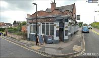
The Robin Hood seen from Middle Road / Google Earth Street View.]
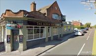
The Robin Hood seen from South East Road / Google Earth Street View.]
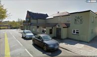
The Robin Hood seen from South East Road / Google Earth Street View.]
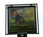
Signs of the Robin Hood / Shazz, 1 Mar. 2013, Creative Commons via Geograph.


