Robin Hood (Royston, Barnsley) (2)

By Henrik Thiil Nielsen, 2016-15-11. Revised by Henrik Thiil Nielsen, 2020-05-16.
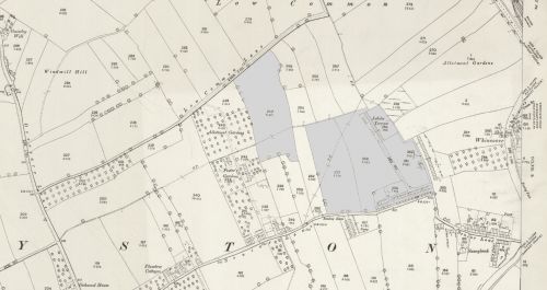
Robin Hood occurs as a field name or characterization of no less than four plots of land in the 1845 MS tithe award for Royston, which is now a suburban village within the Metropolitan borough of Barnsley, located c. 14 km SW of Wentbridge. Three of the plots form one continuous area, while the fourth, entered separately at IRHB as Robin Hood (Royston, Barnsley) (1), is situated slightly north-west of them, the distance between it and the nearest 'Robin Hood' plot being no more than c. 35 m.
The three connected plots, here treated as one area in view of their common name, and the adjacent fourth plot are best discussed together. The details provided for each in the tithe award, together with the corresponding field numbers in the earliest 25" O.S. maps (for which see below), are as follows:
- Plot No. 158. Name and Description of Lands and Premises: 'Humple & Robin Hood'. Owner/occupier: Ball John. State of Cultivation: Arable. Area: 6 acres, 2 roods and 1 perch (Template:AcreRoodPerchToM2 m2). No. 247 on early O.S. maps.
- Plot No. 162. Name and Description of Lands and Premises: 'Robin Hood'. Owner: Sir Theodore Broadhead. Occupier: John Bayldon. State of Cultivation: Arable. Area: 5 acres and 7 perches (Template:AcreRoodPerchToM2 m2). No. 253 on early O.S. maps.
- Plot No. 166. Name and Description of Lands and Premises: 'Robin Hood'. Owner/occupier: John Boyldon, Esq. State of Cultivation: Arable. Area: 4 acres, 2 roods and 1 perch (Template:AcreRoodPerchToM2 m2). No. 258 on early O.S. maps.
- Plot No. 167. Name and Description of Lands and Premises: 'Robin hood & Road'. Owner: Jonathan Ball. Occupier: William Woodcock. State of Cultivation: Arable and waste. Area: 5 acres and 11 perches (Template:AcreRoodPerchToM2 m2).[1] Nos. 259-62, 268 on early O.S. maps.
Robin Hood is listed twice as a field name in the 1845 MS Tithe Award for Royston,[2] which is now a suburban village within the Metropolitan borough of Barnsley, located c. 14 km SW of Wentbridge. With the aid of the MS tithe award[3] and accompanying map,[4] a georeferenced 6" O.S. map of the area online at NLS,[5] and Google Maps, it is possible to establish the coordinates of this locality fairly accurately. The field, shaped roughly like a mirror image capital 'L', is shown (but not named) on 6" O.S. maps of Royston from the period 1894-1949 on the north side of Senior Lane, which morphed into Midland Road during this period. The present Robin Hood Avenue (Royston, Barnsley) more or less forms the western boundary of the area. During the period covered by the O.S. maps at NLS an estate named Jubilee Terrace was located near its northern boundary. The tithe award lists the land as arable, its owner as Jonathan Ball, its occupier as William Woodcock. The plot is listed as "Robin Hood & Road", the area taken up by the road being listed as waste.
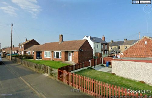
Robin Hood Avenue must obviously have been named after the field. The other field called Robin Hood was located a mere 400 m to the north-west. Template:PnItemQry
Gazetteers
- Not included in Dobson, R. B., ed.; Taylor, J., ed. Rymes of Robyn Hood: an Introduction to the English Outlaw (London, 1976), pp. 293-311.
MS sources
- Tithe award for Royston, online at the Genealogist, piece 43, sub-piece 340, sub-image 031, #162; sub-image 033, #166; sub-image 034, #158, #167 (subscription required)
- acompanying map, online at the Genealogist, piece 43, sub-piece 340, image 001, #158, #162, #166 -67 (subscription required).
Printed sources
- Smith, A.H. The Place-Names of the West Riding of Yorkshire (English Place-Name Society, vols. XXX-XXXVII) (Cambridge, 1961-63), pt. 1, p. 286, refers to this or Robin Hood (Royston, Barnsley) (1).
Maps
- 25" O.S. map Yorkshire CCLXII.12 (1893; surveyed 1891)
- 25" O.S. map Yorkshire CCLXII.12 (1906, rev. 1904) (georeferenced)
- 25" O.S. map Yorkshire CCLXII.12 (1906; rev. 1904)
- 25" O.S. map Yorkshire CCLXII.12 (1918; rev. 1914)
- 25" O.S. map Yorkshire CCLXII.12 (1918; rev. 1914)
- 6" O.S. map Yorkshire CCLXII.SE (1894; surveyed 1891)
- 6" O.S. map Yorkshire CCLXII.SE (1907; rev. 1904)
- 6" O.S. map Yorkshire CCLXII.SE (1907; rev. 1904) (georeferenced)
- 6" O.S. map Yorkshire CCLXII.SE (1932; rev. 1929-30)
- 6" O.S. map Yorkshire CCLXII.SE (1947; rev. 1938)
- 6" O.S. map Yorkshire CCLXII.SE (1949; rev. 1948).
Notes
- ↑ Tithe award for Royston, online at the Genealogist, piece 43, sub-piece 340, sub-image 031, #162; sub-image 033, #166; sub-image 034, #158, #167 (subscription required); acompanying map, online at the Genealogist, piece 43, sub-piece 340, image 001, #158, #162, #166 -67 (subscription required).
- ↑ Smith, A.H. The Place-Names of the West Riding of Yorkshire (English Place-Name Society, vols. XXX-XXXVII) (Cambridge, 1961-63), pt. 1, p. 286, mentions only one. It is not clear which.
- ↑ See scan of 1845 tithe award for Royston, online at the Genealogist (subscription required).
- ↑ See scan of map, online at the Genealogist (subscription required).
- ↑ 6" O.S. map Yorkshire CCLXII.SE (1907; rev. 1904), georeferenced version.

